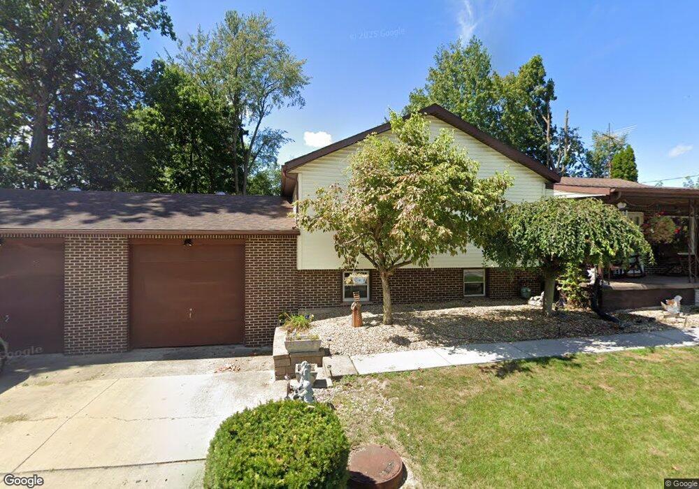
330 Hall Ct Amherst, OH 44001
Estimated Value: $209,000 - $253,000
3
Beds
1
Bath
1,724
Sq Ft
$135/Sq Ft
Est. Value
About This Home
This home is located at 330 Hall Ct, Amherst, OH 44001 and is currently estimated at $232,264, approximately $134 per square foot. 330 Hall Ct is a home located in Lorain County with nearby schools including Powers Elementary School, Walter G. Nord Middle School, and Amherst Junior High School.
Ownership History
Date
Name
Owned For
Owner Type
Purchase Details
Closed on
Jun 28, 2005
Sold by
Scott John H and Scott Marcia S
Bought by
Scott John H and Scott Marcia S
Current Estimated Value
Purchase Details
Closed on
Apr 16, 2004
Sold by
Estate Of Edna Alice Pinson and Pinson Jerry Dow
Bought by
Scott John S and Scott Marcia S
Home Financials for this Owner
Home Financials are based on the most recent Mortgage that was taken out on this home.
Original Mortgage
$85,000
Outstanding Balance
$40,000
Interest Rate
5.66%
Mortgage Type
Purchase Money Mortgage
Estimated Equity
$192,264
Create a Home Valuation Report for This Property
The Home Valuation Report is an in-depth analysis detailing your home's value as well as a comparison with similar homes in the area
Home Values in the Area
Average Home Value in this Area
Purchase History
| Date | Buyer | Sale Price | Title Company |
|---|---|---|---|
| Scott John H | -- | -- | |
| Scott John S | $112,000 | Sunrise Title |
Source: Public Records
Mortgage History
| Date | Status | Borrower | Loan Amount |
|---|---|---|---|
| Open | Scott John S | $85,000 |
Source: Public Records
Tax History Compared to Growth
Tax History
| Year | Tax Paid | Tax Assessment Tax Assessment Total Assessment is a certain percentage of the fair market value that is determined by local assessors to be the total taxable value of land and additions on the property. | Land | Improvement |
|---|---|---|---|---|
| 2024 | $3,015 | $74,641 | $17,906 | $56,735 |
| 2023 | $2,493 | $52,024 | $13,416 | $38,609 |
| 2022 | $2,390 | $52,024 | $13,416 | $38,609 |
| 2021 | $2,396 | $52,024 | $13,416 | $38,609 |
| 2020 | $2,289 | $44,130 | $11,380 | $32,750 |
| 2019 | $2,244 | $44,130 | $11,380 | $32,750 |
| 2018 | $2,247 | $44,130 | $11,380 | $32,750 |
| 2017 | $2,240 | $41,140 | $9,650 | $31,490 |
| 2016 | $2,258 | $41,140 | $9,650 | $31,490 |
| 2015 | $2,245 | $41,140 | $9,650 | $31,490 |
| 2014 | $2,069 | $37,740 | $8,850 | $28,890 |
| 2013 | $2,076 | $37,740 | $8,850 | $28,890 |
Source: Public Records
Map
Nearby Homes
- 891 Park Ave
- 179 Jackson St
- 1140 Woodside Dr
- 2176 Myla Way
- 653 Brennan Dr
- 825 Cleveland Ave
- 105 N Woodhill Dr
- 0 Middle Ridge Rd Unit 5102632
- 0 Middle Ridge Rd Unit 5160578
- 135 Ridgeland Dr
- 7475 S Dewey Rd
- 923 Longitude Ln
- 812 Bearing Ct
- 726 Sunrise Dr
- V/L Middle Ridge Rd
- 281 English Lakes Blvd Unit 67281
- 394 Long St
- 133 Ambleside Way
- 707 Greenlawn Dr
- 0 Stonebridge Dr