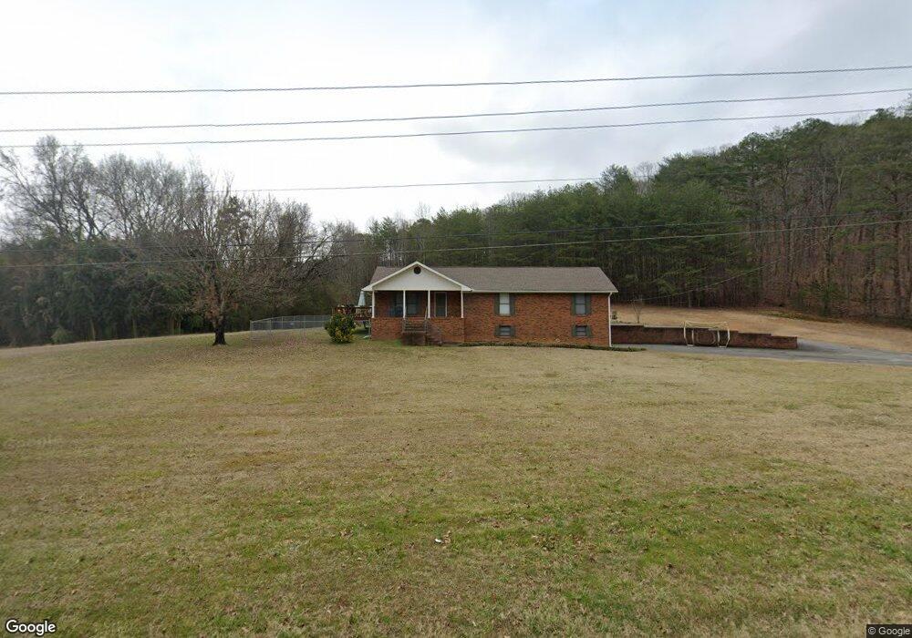
330 Sequoyah Rd Soddy Daisy, TN 37379
Estimated Value: $496,000 - $521,071
--
Bed
4
Baths
2,677
Sq Ft
$190/Sq Ft
Est. Value
About This Home
This home is located at 330 Sequoyah Rd, Soddy Daisy, TN 37379 and is currently estimated at $508,768, approximately $190 per square foot. 330 Sequoyah Rd is a home located in Hamilton County with nearby schools including Ivy Academy Inc and New South Daisy Christian Academy.
Ownership History
Date
Name
Owned For
Owner Type
Purchase Details
Closed on
Jul 15, 2019
Sold by
Hixson Allen C
Bought by
Scoggins Deana D and Scoggins Christopher M
Current Estimated Value
Home Financials for this Owner
Home Financials are based on the most recent Mortgage that was taken out on this home.
Original Mortgage
$260,000
Outstanding Balance
$228,157
Interest Rate
3.9%
Mortgage Type
New Conventional
Estimated Equity
$280,611
Purchase Details
Closed on
Aug 31, 2018
Sold by
Supplement Brown Barbara K and Supplement William Avery Brown
Bought by
Hixson Allen C
Purchase Details
Closed on
Nov 15, 2010
Sold by
Regions Bank
Bought by
Brown John H and Brown Barbara K
Purchase Details
Closed on
Sep 18, 1997
Sold by
Brown John H and Brown Barbara K
Bought by
Pioneer Bank and William Avery Brown Supplemental Care Tr
Purchase Details
Closed on
Mar 29, 1996
Sold by
Aslinger Vada Jo
Bought by
Brown John H and Brown Barbara K
Create a Home Valuation Report for This Property
The Home Valuation Report is an in-depth analysis detailing your home's value as well as a comparison with similar homes in the area
Home Values in the Area
Average Home Value in this Area
Purchase History
| Date | Buyer | Sale Price | Title Company |
|---|---|---|---|
| Scoggins Deana D | $333,000 | Realty T&E Svcs Inc | |
| Hixson Allen C | $140,000 | Realty Title & Escrow Svcs I | |
| Brown John H | -- | None Available | |
| Pioneer Bank | -- | Legal Title & Escrow Inc | |
| Brown John H | $155,000 | -- |
Source: Public Records
Mortgage History
| Date | Status | Borrower | Loan Amount |
|---|---|---|---|
| Open | Scoggins Deana D | $260,000 |
Source: Public Records
Tax History Compared to Growth
Tax History
| Year | Tax Paid | Tax Assessment Tax Assessment Total Assessment is a certain percentage of the fair market value that is determined by local assessors to be the total taxable value of land and additions on the property. | Land | Improvement |
|---|---|---|---|---|
| 2024 | $1,963 | $87,750 | $0 | $0 |
| 2023 | $2,951 | $87,750 | $0 | $0 |
| 2022 | $2,951 | $87,750 | $0 | $0 |
| 2021 | $2,951 | $87,750 | $0 | $0 |
| 2020 | $3,137 | $57,475 | $0 | $0 |
| 2019 | $2,376 | $57,475 | $0 | $0 |
| 2018 | $2,376 | $57,475 | $0 | $0 |
| 2017 | $2,376 | $57,475 | $0 | $0 |
| 2016 | $2,294 | $0 | $0 | $0 |
| 2015 | $2,294 | $55,500 | $0 | $0 |
| 2014 | $2,294 | $0 | $0 | $0 |
Source: Public Records
Map
Nearby Homes
- 9839 Walnut St
- 698 Green Pond Rd
- 874 Ponderosa Dr
- 9885 Lovell Rd
- 623 Sunset Valley Dr
- 10206 Card Rd
- 9811 Lovell Rd
- 9693 W Ridge Trail Rd
- 9606 Shooting Star Cir
- 10192 Big Pine Ln
- 9709 Lovell Rd
- 10280 Card Rd
- 9851 Millsaps St
- 0 Lovell Rd Unit 1523036
- 9607 Barbee Rd Unit 87
- 110 Mountain View Dr
- 110 Mountainview Dr
- 9443 Harris St
- 1097 Harvest Knoll Ln
- 168 Turner Rd
- 330 Sequoyah Rd
- 9982 Miller Rd
- 498 Rock Quarry Rd
- 502 Green Pond Rd
- 498 Rock Quarry Rd
- 9992 Miller Rd
- 9989 Miller Rd
- 516 Neighbors Dr
- 9973 Miller Rd
- 508 Neighbors Dr
- 492 Green Pond Rd
- 520 Neighbors Dr
- 9996 Miller Rd
- 484 Green Pond Rd
- 494 Rock Quarry Rd
- 481 Green Pond Rd
- 497 Rock Quarry Rd
- 509 Neighbors Dr
- 513 Neighbors Dr
- 505 Neighbors Dr