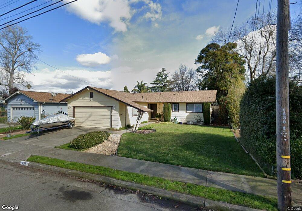
330 Westbrook Dr Santa Rosa, CA 95401
Estimated Value: $612,931 - $635,000
3
Beds
2
Baths
1,248
Sq Ft
$500/Sq Ft
Est. Value
About This Home
This home is located at 330 Westbrook Dr, Santa Rosa, CA 95401 and is currently estimated at $623,983, approximately $499 per square foot. 330 Westbrook Dr is a home located in Sonoma County with nearby schools including Elsie Allen High School, College Oak Montessori School, and St. Michael's Orthodox School.
Ownership History
Date
Name
Owned For
Owner Type
Purchase Details
Closed on
Jul 19, 2017
Sold by
Humphreys Elke and Pedersen Elke D
Bought by
Briggs Andrew
Current Estimated Value
Purchase Details
Closed on
Oct 18, 2007
Sold by
Pedersen Elke D
Bought by
Pedersen Elke D
Home Financials for this Owner
Home Financials are based on the most recent Mortgage that was taken out on this home.
Original Mortgage
$356,000
Interest Rate
6.27%
Mortgage Type
New Conventional
Purchase Details
Closed on
Aug 7, 2001
Sold by
Pedersen Howard W
Bought by
Pedersen Elke D
Home Financials for this Owner
Home Financials are based on the most recent Mortgage that was taken out on this home.
Original Mortgage
$212,000
Interest Rate
7.7%
Purchase Details
Closed on
May 24, 1996
Sold by
Walsvick Pauline D
Bought by
Walsvick Pauline D
Create a Home Valuation Report for This Property
The Home Valuation Report is an in-depth analysis detailing your home's value as well as a comparison with similar homes in the area
Purchase History
| Date | Buyer | Sale Price | Title Company |
|---|---|---|---|
| Briggs Andrew | $422,500 | First American Title Company | |
| Pedersen Elke D | -- | North Bay Title Company | |
| Pedersen Elke D | -- | Chicago Title Co | |
| Pedersen Elke D | $265,000 | Chicago Title Co | |
| Walsvick Pauline D | -- | -- |
Source: Public Records
Mortgage History
| Date | Status | Borrower | Loan Amount |
|---|---|---|---|
| Previous Owner | Pedersen Elke D | $356,000 | |
| Previous Owner | Pedersen Elke D | $212,000 |
Source: Public Records
Tax History
| Year | Tax Paid | Tax Assessment Tax Assessment Total Assessment is a certain percentage of the fair market value that is determined by local assessors to be the total taxable value of land and additions on the property. | Land | Improvement |
|---|---|---|---|---|
| 2025 | $5,346 | $480,727 | $192,290 | $288,437 |
| 2024 | $5,346 | $471,302 | $188,520 | $282,782 |
| 2023 | $5,346 | $462,062 | $184,824 | $277,238 |
| 2022 | $5,041 | $453,002 | $181,200 | $271,802 |
| 2021 | $4,976 | $444,121 | $177,648 | $266,473 |
| 2020 | $4,844 | $439,568 | $175,827 | $263,741 |
| 2019 | $4,784 | $430,950 | $172,380 | $258,570 |
| 2018 | $4,820 | $422,500 | $169,000 | $253,500 |
| 2017 | $3,771 | $337,313 | $127,287 | $210,026 |
| 2016 | $3,739 | $330,700 | $124,792 | $205,908 |
| 2015 | $3,622 | $325,734 | $122,918 | $202,816 |
| 2014 | $2,846 | $263,000 | $99,000 | $164,000 |
Source: Public Records
Map
Nearby Homes
- 300 Stony Point Rd Unit 126
- 300 Stony Point Rd Unit 139
- 1555 W 3rd St
- 1702 Glenbrook Dr Unit D
- 334 Brockhurst Dr
- 1708 Glenbrook Dr Unit F
- 77 Romani Ct
- 62 Romani Ct
- 611 Willrush St
- 713 Blair Place
- 717 Blair Place
- 724 Agnew Place
- 590 Laurel Grove Cir
- 588 Roseland Ave
- 98 Leisure Park Cir
- 786 Simpson Place
- 104 Leisure Park Cir
- 158 N Dutton Ave Unit 4
- 24 Leisure Park Cir
- 303 Boyce St
- 320 Westbrook Dr
- 338 Westbrook Dr
- 233 Broadmoor St
- 229 Broadmoor St
- 314 Westbrook Dr
- 342 Westbrook Dr
- 237 Broadmoor St
- 225 Broadmoor St
- 343 Westbrook Dr
- 1607 Romero Way
- 301 Broadmoor St
- 221 Broadmoor St
- 346 Westbrook Dr
- 310 Westbrook Dr
- 1616 Romero Way
- 1613 Romero Way
- 349 Westbrook Dr
- 1612 Edgewood Ln
- 305 Broadmoor St
- 217 Broadmoor St
Your Personal Tour Guide
Ask me questions while you tour the home.