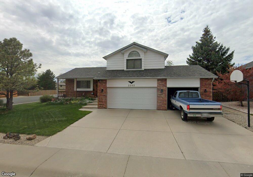
3303 Honey Locust Dr Loveland, CO 80538
Estimated Value: $521,000 - $595,000
3
Beds
4
Baths
2,019
Sq Ft
$275/Sq Ft
Est. Value
About This Home
This home is located at 3303 Honey Locust Dr, Loveland, CO 80538 and is currently estimated at $555,865, approximately $275 per square foot. 3303 Honey Locust Dr is a home located in Larimer County with nearby schools including Peakview Academy at Conrad Ball, Mary Blair Elementary School, and Mountain View High School.
Ownership History
Date
Name
Owned For
Owner Type
Purchase Details
Closed on
Jan 27, 2020
Sold by
Rex Allen Mannon Trust
Bought by
Pamela Kay Mannon Trust
Current Estimated Value
Purchase Details
Closed on
Dec 11, 2009
Sold by
Mannon Rex A and Mannon Pamela K
Bought by
Trust-2009 Rex Allen Mannon
Purchase Details
Closed on
Oct 1, 1993
Sold by
Burns D E Construction Co
Bought by
Mannon Rex A
Purchase Details
Closed on
Jul 1, 1993
Sold by
Burns D E Construction Co
Bought by
Burns D E Construction Co
Create a Home Valuation Report for This Property
The Home Valuation Report is an in-depth analysis detailing your home's value as well as a comparison with similar homes in the area
Home Values in the Area
Average Home Value in this Area
Purchase History
| Date | Buyer | Sale Price | Title Company |
|---|---|---|---|
| Pamela Kay Mannon Trust | -- | None Available | |
| Pamela Kay Mannon Trust 2009 | -- | None Available | |
| Trust-2009 Rex Allen Mannon | -- | None Available | |
| Mannon Rex A | $113,700 | -- | |
| Burns D E Construction Co | -- | -- |
Source: Public Records
Tax History Compared to Growth
Tax History
| Year | Tax Paid | Tax Assessment Tax Assessment Total Assessment is a certain percentage of the fair market value that is determined by local assessors to be the total taxable value of land and additions on the property. | Land | Improvement |
|---|---|---|---|---|
| 2025 | $2,230 | $38,324 | $3,216 | $35,108 |
| 2024 | $2,150 | $38,324 | $3,216 | $35,108 |
| 2022 | $1,689 | $28,175 | $3,336 | $24,839 |
| 2021 | $1,735 | $28,986 | $3,432 | $25,554 |
| 2020 | $2,188 | $27,513 | $3,432 | $24,081 |
| 2019 | $1,592 | $27,513 | $3,432 | $24,081 |
| 2018 | $1,524 | $25,718 | $3,456 | $22,262 |
| 2017 | $1,312 | $25,718 | $3,456 | $22,262 |
| 2016 | $1,179 | $24,039 | $3,821 | $20,218 |
| 2015 | $1,749 | $24,040 | $3,820 | $20,220 |
| 2014 | $1,602 | $21,310 | $3,820 | $17,490 |
Source: Public Records
Map
Nearby Homes
- 3244 Hawthorn Dr
- 502 Honey Locust Dr
- 3402 White Ash Ct
- 1009 Blue Spruce Place
- 367 Limber Place
- 6429 Union Creek Dr
- 6465 Union Creek Dr
- 2437 Mountain View Dr
- 1208 Silver Fir Dr
- 3321 Butternut Dr
- 3638 Butternut Dr Unit 7A
- 171 E 42nd St Unit C
- 2562 Tupelo Dr
- 324 Sagewood Dr
- 119 E 42nd St Unit 3B
- 4342 Sunridge Dr
- 4105 N Garfield Ave Unit 100
- 4105 N Garfield Ave Unit 61
- 2526 Silver Fir Ave
- 2281 N Garfield Ave
- 3311 Honey Locust Dr
- 3300 Fillmore Ave
- 3328 Fillmore Ave
- 3304 Honey Locust Dr
- 457 Hawthorn Dr
- 3325 Honey Locust Dr
- 445 Hawthorn Dr
- 3316 Honey Locust Dr
- 433 Hawthorn Dr
- 3268 Honey Locust Dr
- 3362 Fillmore Ave
- 3328 Honey Locust Dr
- 302 Spring Snow Dr
- 421 Hawthorn Dr
- 3305 Indigo Ct
- 3337 Honey Locust Dr
- 3317 Indigo Ct
- 3256 Honey Locust Dr
- 3394 Fillmore Ave
- 409 Hawthorn Dr