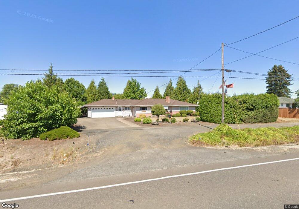
3303 NW Highway 47 Forest Grove, OR 97116
Estimated Value: $575,000 - $699,814
4
Beds
2
Baths
2,188
Sq Ft
$291/Sq Ft
Est. Value
About This Home
This home is located at 3303 NW Highway 47, Forest Grove, OR 97116 and is currently estimated at $637,407, approximately $291 per square foot. 3303 NW Highway 47 is a home located in Washington County with nearby schools including Harvey Clarke Elementary School, Tom McCall Upper Elementary School, and Neil Armstrong Middle School.
Ownership History
Date
Name
Owned For
Owner Type
Purchase Details
Closed on
Jun 26, 2025
Sold by
Peschka Revocable Trust and Daskalos Patricia J
Bought by
Barbara J Peschka Living Trust and Daskalos
Current Estimated Value
Purchase Details
Closed on
Sep 14, 2022
Sold by
Richard D Peschka Living Trust
Bought by
Peschka Revocable Trust
Purchase Details
Closed on
Apr 12, 2006
Sold by
Peschka Richard D and Peschka Barbara J
Bought by
Peschka Richard D and Peschka Barbara J
Create a Home Valuation Report for This Property
The Home Valuation Report is an in-depth analysis detailing your home's value as well as a comparison with similar homes in the area
Home Values in the Area
Average Home Value in this Area
Purchase History
| Date | Buyer | Sale Price | Title Company |
|---|---|---|---|
| Barbara J Peschka Living Trust | -- | None Listed On Document | |
| Peschka Revocable Trust | -- | -- | |
| Peschka Richard D | -- | None Available |
Source: Public Records
Tax History Compared to Growth
Tax History
| Year | Tax Paid | Tax Assessment Tax Assessment Total Assessment is a certain percentage of the fair market value that is determined by local assessors to be the total taxable value of land and additions on the property. | Land | Improvement |
|---|---|---|---|---|
| 2026 | $5,029 | $389,740 | -- | -- |
| 2025 | $5,029 | $378,390 | -- | -- |
| 2024 | $4,839 | $367,370 | -- | -- |
| 2023 | $4,839 | $356,670 | $0 | $0 |
| 2022 | $4,177 | $356,670 | $0 | $0 |
| 2021 | $4,148 | $336,210 | $0 | $0 |
| 2020 | $4,158 | $326,420 | $0 | $0 |
| 2019 | $4,053 | $316,920 | $0 | $0 |
| 2018 | $3,985 | $307,690 | $0 | $0 |
| 2017 | $3,878 | $298,730 | $0 | $0 |
| 2016 | $3,774 | $290,030 | $0 | $0 |
| 2015 | $3,522 | $281,590 | $0 | $0 |
| 2014 | $3,509 | $273,390 | $0 | $0 |
Source: Public Records
Map
Nearby Homes
- 3131 NW Highway 47
- 2129 Colby Ln Unit Lot 75
- 2123 Colby Ln Unit Lot 74
- 3601 Chestnut St Unit Lot 44
- 2149 36th Unit Lot 59
- 3559 Chestnut St Unit Lot 43
- 3610 Ash St Unit Lot 17
- 2002 Aspen Ln
- 3609 Main St
- 3605 Main St
- 2091 35th Ave
- 3613 Chestnut St Unit Lot 48
- Pacific Plan at Davis Estates
- Newport Plan at Davis Estates
- Dahlia Plan at Davis Estates
- Azalea Plan at Davis Estates
- 2043 35th Ave
- 2035 35th Ave
- 3594 Ash St Unit Lot 25
- 2081 Silverstone Dr
- 3369 NW Highway 47
- 3207 NW Highway 47
- 3397 NW Highway 47
- 3131 NW Highway 47
- 2805 NW Highway 47
- 41997 NW Purdin Rd
- 2147 Colby Ln Unit Lot 78
- 2627 NW Highway 47
- 42069 NW Purdin Rd
- 41965 NW Purdin Rd
- 41183 NW Verboort Rd
- 41110 NW Verboort Rd
- 2581 NW Highway 47
- 2137 35th Ave
- 2129 35th Ave
- 3501 Chestnut St
- 2121 35th Ave
- 2113 35th Ave
- 2105 35th Ave
- 3225 NW McKibbin Rd