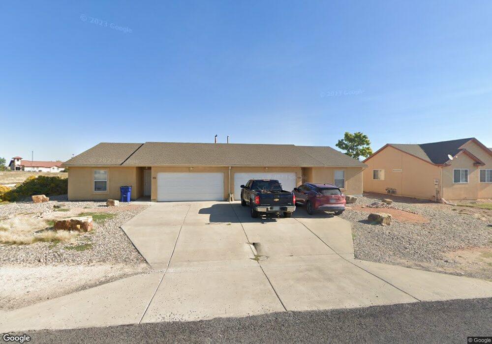
331 E Stardust Dr Unit 333 Pueblo, CO 81007
Estimated Value: $398,432 - $482,000
4
Beds
4
Baths
2,396
Sq Ft
$185/Sq Ft
Est. Value
About This Home
This home is located at 331 E Stardust Dr Unit 333, Pueblo, CO 81007 and is currently estimated at $443,144, approximately $184 per square foot. 331 E Stardust Dr Unit 333 is a home located in Pueblo County with nearby schools including Liberty Point Elementary School, Liberty Point International School, and Pueblo West High School.
Ownership History
Date
Name
Owned For
Owner Type
Purchase Details
Closed on
Feb 4, 2014
Sold by
Latner Generation Llc
Bought by
Borcic Anthony
Current Estimated Value
Purchase Details
Closed on
May 1, 2007
Sold by
Latner Generation Llc
Bought by
Borcic Anthony
Purchase Details
Closed on
Dec 12, 2006
Sold by
Borcic Anthony N
Bought by
Latner Generation Llc
Purchase Details
Closed on
Dec 14, 2005
Sold by
Weber Kevin J and Weber Denise M
Bought by
Borcic Anthony N
Purchase Details
Closed on
Dec 26, 1995
Sold by
Pueblo West Metro Dist
Bought by
Weber Kevin J + Denise M
Purchase Details
Closed on
Dec 29, 1992
Sold by
Nt
Bought by
Pueblo West Metro Dist
Purchase Details
Closed on
Sep 13, 1979
Sold by
Nt
Bought by
Nt
Purchase Details
Closed on
Dec 3, 1971
Sold by
Lawyers Title Of Pueblo Tr
Bought by
Nt
Create a Home Valuation Report for This Property
The Home Valuation Report is an in-depth analysis detailing your home's value as well as a comparison with similar homes in the area
Home Values in the Area
Average Home Value in this Area
Purchase History
| Date | Buyer | Sale Price | Title Company |
|---|---|---|---|
| Borcic Anthony | -- | None Available | |
| Borcic Anthony | -- | None Available | |
| Latner Generation Llc | -- | None Available | |
| Borcic Anthony N | $8,250 | Stewart Title Of Pueblo | |
| Weber Kevin J + Denise M | $7,800 | -- | |
| Pueblo West Metro Dist | -- | -- | |
| Nt | -- | -- | |
| Nt | $5,000 | -- |
Source: Public Records
Tax History Compared to Growth
Tax History
| Year | Tax Paid | Tax Assessment Tax Assessment Total Assessment is a certain percentage of the fair market value that is determined by local assessors to be the total taxable value of land and additions on the property. | Land | Improvement |
|---|---|---|---|---|
| 2024 | $2,034 | $20,260 | -- | -- |
| 2023 | $2,057 | $23,950 | $3,350 | $20,600 |
| 2022 | $1,610 | $16,039 | $2,040 | $13,999 |
| 2021 | $1,687 | $16,870 | $2,150 | $14,720 |
| 2020 | $1,647 | $16,870 | $2,150 | $14,720 |
| 2019 | $1,643 | $16,445 | $393 | $16,052 |
| 2018 | $1,353 | $13,536 | $324 | $13,212 |
| 2017 | $1,355 | $13,536 | $324 | $13,212 |
| 2016 | $1,411 | $14,124 | $716 | $13,408 |
| 2015 | $1,400 | $14,124 | $716 | $13,408 |
| 2014 | -- | $12,938 | $756 | $12,182 |
Source: Public Records
Map
Nearby Homes
- 385 E Larchmont Dr
- 228 S Caddoa Dr
- 226 E Falcon Dr
- 213 S Dacona Dr
- 293 S Maher Dr
- 288 S Wiggins Dr
- 25 N Fabrication Dr
- 37 Fabrication Dr
- 142 E Croyden Dr
- 189 S Crescent Cir
- 89 Precision Dr
- LOT 39 Swallows Rd
- 161 E Croyden Dr
- TBD E Civic Center Dr
- 861 E Enterprise Dr
- 453 E Enterprise Dr
- 463 E Fraser Dr
- 8 S Glenrose Dr
- 557 E Clarion Dr
- 104 W Idaho Springs Dr
- 331 E Stardust Dr Unit 3
- 325 E Stardust Dr
- 325 E Stardust Dr Unit 2
- 325 Stardust Dr
- 337 E Stardust Dr Unit 339
- 173 E Eads Dr Unit 21
- 319 E Stardust Dr
- 343 E Stardust Dr Unit 5
- 336 E Stardust Dr
- 324 E Stardust Dr
- 324 E Stardust Dr Unit 23
- 349 E Stardust Dr
- 349 E Stardust Dr Unit 351
- 162 S Eads Dr Unit 5
- 316 E Stardust Dr Unit 318
- 197 S Eads Dr Unit 199
- 346 E Stardust Dr Unit 348
- 312 E Stardust Dr Unit 314
- 355 E Stardust Dr Unit 7
- 0 S Eads Dr