Estimated Value: $236,000 - $310,000
4
Beds
2
Baths
1,688
Sq Ft
$162/Sq Ft
Est. Value
About This Home
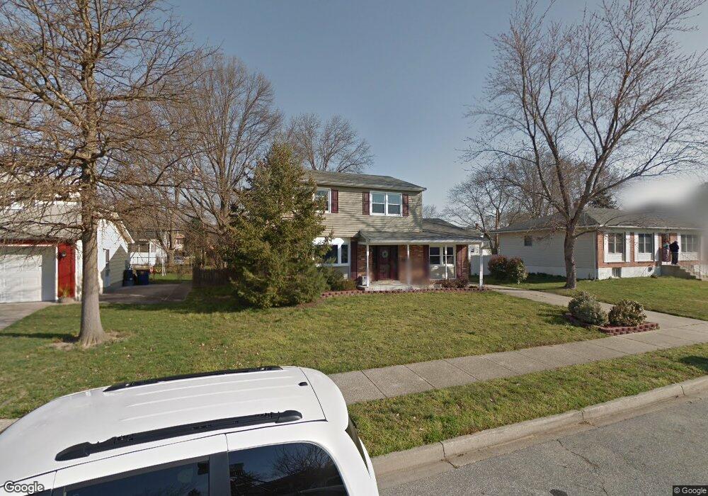
This home is located at 331 Mockingbird Ave, Dover, DE 19904 and is currently estimated at $274,047, approximately $162 per square foot. 331 Mockingbird Ave is a home located in Kent County with nearby schools including W. Reily Brown Elementary School, Fred Fifer Middle School, and Caesar Rodney High School.
Ownership History
Date
Name
Owned For
Owner Type
Purchase Details
Closed on
Sep 29, 2006
Sold by
Hill Marvin R
Bought by
Hill Marvin R and Hill Norma
Current Estimated Value
Home Financials for this Owner
Home Financials are based on the most recent Mortgage that was taken out on this home.
Original Mortgage
$46,000
Interest Rate
6.4%
Mortgage Type
Seller Take Back
Create a Home Valuation Report for This Property
The Home Valuation Report is an in-depth analysis detailing your home's value as well as a comparison with similar homes in the area
Home Values in the Area
Average Home Value in this Area
Purchase History
| Date | Buyer | Sale Price | Title Company |
|---|---|---|---|
| Hill Marvin R | -- | Title Source Inc |
Source: Public Records
Mortgage History
| Date | Status | Borrower | Loan Amount |
|---|---|---|---|
| Closed | Hill Marvin R | $46,000 |
Source: Public Records
Tax History
| Year | Tax Paid | Tax Assessment Tax Assessment Total Assessment is a certain percentage of the fair market value that is determined by local assessors to be the total taxable value of land and additions on the property. | Land | Improvement |
|---|---|---|---|---|
| 2025 | $995 | $247,900 | $89,300 | $158,600 |
| 2024 | $991 | $247,900 | $89,300 | $158,600 |
| 2023 | $1,054 | $41,300 | $9,700 | $31,600 |
| 2022 | $995 | $41,300 | $9,700 | $31,600 |
| 2021 | $987 | $41,300 | $9,700 | $31,600 |
| 2020 | $971 | $41,300 | $9,700 | $31,600 |
| 2019 | $933 | $41,300 | $9,700 | $31,600 |
| 2018 | $899 | $41,300 | $9,700 | $31,600 |
| 2017 | $874 | $41,300 | $0 | $0 |
| 2016 | $856 | $41,300 | $0 | $0 |
| 2015 | $716 | $41,300 | $0 | $0 |
| 2014 | $715 | $41,300 | $0 | $0 |
Source: Public Records
Map
Nearby Homes
- 311 Mimosa Ave
- 248 Webbs Ln
- 361 Kesselring Ave
- 48 John Collins Cir
- 207 Gunning Bedford Dr
- 1431 Joshua Clayton Rd
- 272 Gunning Bedford Dr
- 1 Edgewood Rd
- 89 Cooper Rd
- 949 Westview Terrace
- 288 Cambridge Rd
- 135 N Fairfield Dr
- 142 Carter Ln
- 54 Huntley Cir
- 22 Howell St
- 100 S Shore Dr
- 511 Little Eden Way
- 89 S Shore Dr
- 79 Oakcrest Dr
- 118 Creek Bend Rd
- 327 Mockingbird Ave
- 335 Mockingbird Ave
- 324 Kesselring Ave
- 326 Kesselring Ave
- 322 Kesselring Ave
- 339 Mockingbird Ave
- 323 Mockingbird Ave
- 330 Mockingbird Ave
- 326 Mockingbird Ave
- 334 Mockingbird Ave
- 320 Kesselring Ave
- 330 Kesselring Ave
- 343 Mockingbird Ave
- 319 Mockingbird Ave
- 322 Mockingbird Ave
- 340 Mockingbird Ave
- 318 Kesselring Ave
- 334 Kesselring Ave
- 318 Mockingbird Ave
- 344 Mockingbird Ave
Your Personal Tour Guide
Ask me questions while you tour the home.