
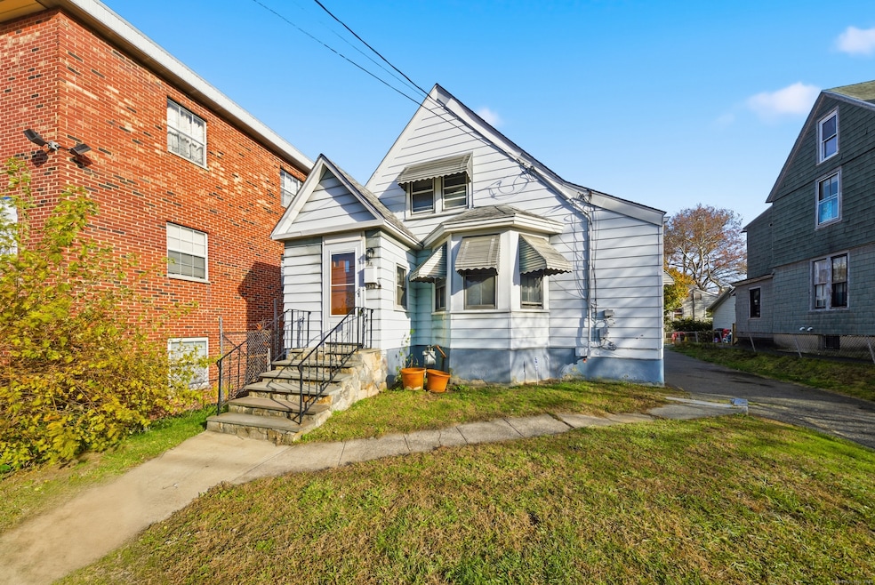
332 Palisade Ave Bridgeport, CT 06610
North Bridgeport NeighborhoodEstimated payment $1,957/month
3
Beds
1
Bath
1,001
Sq Ft
$299
Price per Sq Ft
Highlights
- Beach Access
- Heating System Uses Steam
- Level Lot
- Cape Cod Architecture
About This Home
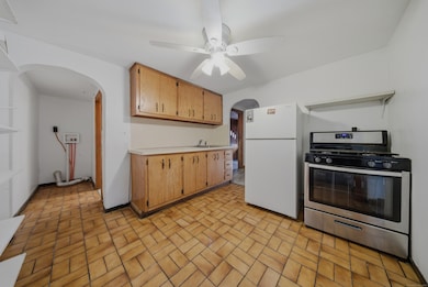
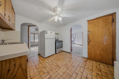
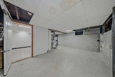
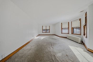
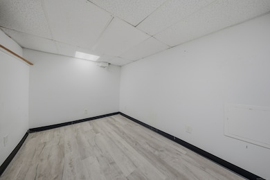
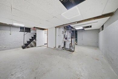
Opportunity Alert at 332 Palisade! ... If you've been waiting for a home you can truly make your own, THIS is the one. Bring your ideas, bring your style - this place is ready for a full glow-up! Inside, you'll find three bedrooms (one on the main level and two upstairs), plus a full bathroom and laundry hookups conveniently located on the main floor. There's a very large living room and a bright sunroom/bonus room in the back surrounded by windows - the perfect spot to relax, create, or unwind. But wait... the basement takes it up a notch! You've got a big room downstairs that can easily become a family room, media room, or your ultimate hangout space. PLUS a separate bonus room for whatever else you need - storage, office, gym, crafts... you name it. Outside, enjoy a grassy backyard, a two-car detached garage, and a nice driveway with plenty of parking. Yes, it needs some love - but the potential here is huge. 332 Palisade is your chance to turn a fixer into a dream home. Don't sleep on this one!
Listing Agent
Top Tier Realty Group, LLC Brokerage Phone: (203) 521-5339 License #REB.0794757 Listed on: 11/20/2025
Home Details
Home Type
- Single Family
Est. Annual Taxes
- $4,540
Year Built
- Built in 1882
Lot Details
- 5,227 Sq Ft Lot
- Level Lot
- Property is zoned RC
Parking
- 2 Car Garage
Home Design
- Cape Cod Architecture
- Asphalt Shingled Roof
- Aluminum Siding
- Masonry
Interior Spaces
- 1,001 Sq Ft Home
- Partially Finished Basement
- Basement Fills Entire Space Under The House
- Gas Cooktop
- Laundry on main level
Bedrooms and Bathrooms
- 3 Bedrooms
- 1 Full Bathroom
Outdoor Features
- Beach Access
Utilities
- Heating System Uses Steam
- Heating System Uses Natural Gas
Listing and Financial Details
- Assessor Parcel Number 27840
Map
Create a Home Valuation Report for This Property
The Home Valuation Report is an in-depth analysis detailing your home's value as well as a comparison with similar homes in the area
Home Values in the Area
Average Home Value in this Area
Tax History
| Year | Tax Paid | Tax Assessment Tax Assessment Total Assessment is a certain percentage of the fair market value that is determined by local assessors to be the total taxable value of land and additions on the property. | Land | Improvement |
|---|---|---|---|---|
| 2025 | $4,540 | $104,491 | $46,651 | $57,840 |
| 2024 | $4,540 | $104,491 | $46,651 | $57,840 |
| 2023 | $4,540 | $104,491 | $46,651 | $57,840 |
| 2022 | $4,540 | $104,491 | $46,651 | $57,840 |
| 2021 | $4,540 | $104,491 | $46,651 | $57,840 |
| 2020 | $3,360 | $62,240 | $16,840 | $45,400 |
| 2019 | $3,360 | $62,240 | $16,840 | $45,400 |
| 2018 | $3,384 | $62,240 | $16,840 | $45,400 |
| 2017 | $3,384 | $62,240 | $16,840 | $45,400 |
| 2016 | $3,384 | $62,240 | $16,840 | $45,400 |
| 2015 | $4,191 | $99,310 | $37,040 | $62,270 |
| 2014 | $4,191 | $99,310 | $37,040 | $62,270 |
Source: Public Records
Property History
| Date | Event | Price | List to Sale | Price per Sq Ft |
|---|---|---|---|---|
| 11/20/2025 11/20/25 | For Sale | $299,000 | -- | $299 / Sq Ft |
Source: SmartMLS
Purchase History
| Date | Type | Sale Price | Title Company |
|---|---|---|---|
| Warranty Deed | -- | None Available | |
| Warranty Deed | $50,000 | -- | |
| Warranty Deed | $50,000 | -- |
Source: Public Records
About the Listing Agent
Lisa Nussbaum is a real estate broker with Top Tier Realty Group, serving Bridgeport, CT and nearby areas. She works with tenants, buyers, landlords, and sellers, offering responsive service and clear communication. Lisa focuses on understanding client needs and delivering results, whether helping find the right home or marketing a property to sell or rent.
Lisa's Other Listings
Source: SmartMLS
MLS Number: 24141037
APN: BRID-001928-000003
Disclaimer: Certain information contained herein is derived from information provided by parties other than Homes.com. All information provided is deemed reliable, but is not guaranteed to be accurate and should be independently verified.
![]() IDX information is provided exclusively for personal, non-commercial use, and may not be used for any purpose other than to identify prospective properties consumers may be interested in purchasing. Information is deemed reliable but not guaranteed.
IDX information is provided exclusively for personal, non-commercial use, and may not be used for any purpose other than to identify prospective properties consumers may be interested in purchasing. Information is deemed reliable but not guaranteed.
Nearby Homes
- 5 Granfield Ave
- 33 Granfield Ave
- 37 Granfield Ave Unit 39
- 43 Granfield Ave Unit 45
- 334 Dover St
- 302 Dover St
- 287 Dover St Unit 293
- 242 Pearl Harbor St
- 1575 Boston Ave Unit B2
- 0 63 Court A Bld 18 Ct Unit 24110827
- 357 Granfield Ave Unit B
- 361 Granfield Ave Unit Bldg 8, A
- 3 Granfield Ave
- 69 Court d Unit 82
- 401 Granfield Ave Unit 2
- 14 Court a
- 260 Success Ave Unit 21
- 295 N Bishop Bld 92 Ave Unit 13
- 440 Success Ave Unit BLDG-86, APT-18
- 1922 Boston Ave Unit 1924
- 360 Palisade Ave Unit B09
- 366 Remington St
- 45 Birdsey St
- 125 Granfield Ave Unit 3E
- 327 Dover St Unit 329
- 76 Birdsey St Unit 1R
- 301 Dover St Unit 2
- 289 Dover St Unit 2L
- 382 Bond St Unit 2
- 380 Bond St
- 76 Palisade Ave Unit A3
- 76 Palisade Ave Unit B3
- 540 Bond St
- 600 Bond St Unit 102
- 600 Bond St Unit 113
- 600 Bond St Unit 112
- 430 Pearl Harbor St
- 260 Sheridan St Unit 2nd
- 225 Clermont Ave Unit 2
- 2078 Seaview Ave Unit 2