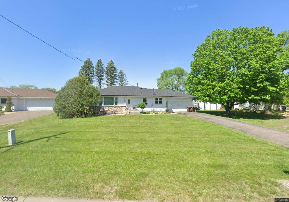
332 River Rd NE Hanover, MN 55341
Estimated Value: $360,000 - $385,000
4
Beds
2
Baths
1,110
Sq Ft
$336/Sq Ft
Est. Value
About This Home
This home is located at 332 River Rd NE, Hanover, MN 55341 and is currently estimated at $372,649, approximately $335 per square foot. 332 River Rd NE is a home located in Wright County with nearby schools including Hanover Elementary School, Buffalo Community Middle School, and Buffalo Senior High School.
Ownership History
Date
Name
Owned For
Owner Type
Purchase Details
Closed on
Oct 11, 2018
Sold by
Neururer Aaron C and Frost Neururer Rachel M
Bought by
Mattson Nicholas T
Current Estimated Value
Home Financials for this Owner
Home Financials are based on the most recent Mortgage that was taken out on this home.
Original Mortgage
$237,500
Outstanding Balance
$207,114
Interest Rate
4.5%
Mortgage Type
New Conventional
Estimated Equity
$165,535
Purchase Details
Closed on
Jun 27, 2002
Sold by
Wagner George H and Wagner Marjorie
Bought by
Neurgrer Aaron C
Create a Home Valuation Report for This Property
The Home Valuation Report is an in-depth analysis detailing your home's value as well as a comparison with similar homes in the area
Home Values in the Area
Average Home Value in this Area
Purchase History
| Date | Buyer | Sale Price | Title Company |
|---|---|---|---|
| Mattson Nicholas T | $250,000 | Minnesota Title Corporate | |
| Neurgrer Aaron C | $180,000 | -- |
Source: Public Records
Mortgage History
| Date | Status | Borrower | Loan Amount |
|---|---|---|---|
| Open | Mattson Nicholas T | $237,500 |
Source: Public Records
Tax History
| Year | Tax Paid | Tax Assessment Tax Assessment Total Assessment is a certain percentage of the fair market value that is determined by local assessors to be the total taxable value of land and additions on the property. | Land | Improvement |
|---|---|---|---|---|
| 2025 | $3,438 | $331,100 | $100,000 | $231,100 |
| 2024 | $3,472 | $320,100 | $100,000 | $220,100 |
| 2023 | $3,246 | $321,200 | $100,000 | $221,200 |
| 2022 | $3,056 | $285,300 | $80,000 | $205,300 |
| 2021 | $3,040 | $239,200 | $55,000 | $184,200 |
| 2020 | $2,664 | $228,300 | $55,000 | $173,300 |
| 2019 | $2,104 | $200,900 | $0 | $0 |
| 2018 | $1,982 | $155,800 | $0 | $0 |
| 2017 | $1,854 | $148,400 | $0 | $0 |
| 2016 | $1,824 | $0 | $0 | $0 |
| 2015 | $1,756 | $0 | $0 | $0 |
| 2014 | -- | $0 | $0 | $0 |
Source: Public Records
Map
Nearby Homes
- 291 Liberty Dr
- 335 Liberty Dr
- 371 Liberty Dr
- 11236 Freedom Way
- 11240 Freedom Way
- 347 Riverview Cir
- 11359 5th St NE
- Summit Plan at River’s Edge
- Edgewater Plan at River’s Edge
- Augusta Villa Plan at River’s Edge
- Maplewood Plan at River’s Edge
- 11367 5th St NE
- Lakewood Plan at River’s Edge
- Brookview Plan at River’s Edge
- Somerset Plan at River’s Edge
- Madison Plan at River’s Edge
- The Waterford Plan at River’s Edge - The Villas at River's Edge
- Windsor Plan at River’s Edge
- The Madison Villa Plan at River’s Edge - The Villas at River's Edge
- Crestview Plan at River’s Edge
- 364 River Rd NE
- 310 River Rd NE
- 11248 Freedom Way
- 11244 Freedom Way
- 284 River Rd NE
- 11248 Liberty Dr
- 11305 Riverview Rd NE
- 404 River Rd NE
- 390 Liberty Dr
- 11232 Freedom Way
- 364 Liberty Dr
- 339 Riverview Cir
- 355 Riverview Rd NE
- 338 Liberty Dr
- 361 Riverview Rd NE
- 302 Liberty Dr
- 257 Liberty Dr
- 257 Irvine Dr
- 11331 Riverview Rd NE
- 11218 Church St NE
Your Personal Tour Guide
Ask me questions while you tour the home.