


333 Ranney Corner Rd Ashfield, MA 01330
Ashfield NeighborhoodEstimated payment $873/month
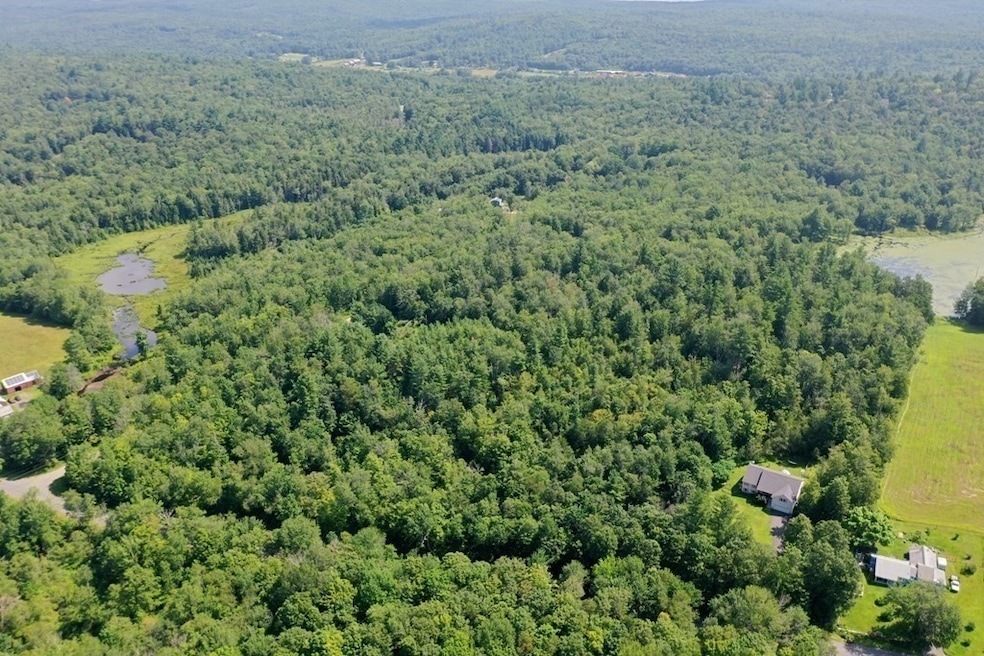
Highlights
- Golf Course Community
- Wetlands on Lot
- Corner Lot
- 11.2 Acre Lot
- Wooded Lot
- No HOA
About This Lot
Lots of possibilities await for building, investment, and more. 11.2 surveyed acres acres with 5 individual remaining lots surveyed out. Quiet country setting but close to Routs 116 and 9.. Some areas with possible views. Town has this assessed as 2 separate parcels as it had an old camp that was taken down. Nothing like this unique situation anywhere around for a family complex or longer term investment. The Perc Test dates are approximate. All lots have passing perc tests that were done just prior to the completion of the survey as shown on the survey plan. NO reports or data exist for older perc tests. Newer percs were not identified as to location. Any and all updates are buyers responsibility. Varied terrane Old Summer Children's Camp building site. 3 power poles brought in off the road for electric access.
Property Details
Property Type
- Land
Est. Annual Taxes
- $1,419
Lot Details
- 11.2 Acre Lot
- Elevated Lot
- Corner Lot
- Level Lot
- Wooded Lot
- 6 Lots in the community
- Additional Parcels
Schools
- Sanderson Elementary School
- Mohawk Middle School
- Mohawk High School
Utilities
- Natural Gas Not Available
- Private Water Source
- Private Sewer
Listing and Financial Details
- Tax Lot 28-81
- Assessor Parcel Number M:0012 B:0000 L:28,3603097
Community Details
Overview
- No Home Owners Association
- Near Conservation Area
Recreation
- Golf Course Community
- Electricity Available at Street
- Wetlands on Lot
Map
Home Values in the Area
Average Home Value in this Area
Tax History
| Year | Tax Paid | Tax Assessment Tax Assessment Total Assessment is a certain percentage of the fair market value that is determined by local assessors to be the total taxable value of land and additions on the property. | Land | Improvement |
|---|---|---|---|---|
| 2025 | $1,419 | $105,400 | $105,400 | $0 |
| 2024 | $1,540 | $105,400 | $105,400 | $0 |
| 2023 | $1,513 | $85,900 | $85,900 | $0 |
| 2022 | $1,432 | $82,400 | $82,400 | $0 |
| 2021 | $1,561 | $82,400 | $82,400 | $0 |
| 2020 | $1,373 | $82,400 | $82,400 | $0 |
| 2019 | $1,428 | $83,200 | $83,200 | $0 |
| 2018 | $1,429 | $83,200 | $83,200 | $0 |
| 2017 | $1,335 | $82,300 | $82,300 | $0 |
| 2016 | $1,353 | $82,300 | $82,300 | $0 |
| 2015 | $1,314 | $82,300 | $82,300 | $0 |
| 2014 | $1,235 | $76,400 | $76,400 | $0 |
Property History
| Date | Event | Price | List to Sale | Price per Sq Ft |
|---|---|---|---|---|
| 10/30/2025 10/30/25 | For Sale | $145,000 | -- | -- |
Purchase History
| Date | Type | Sale Price | Title Company |
|---|---|---|---|
| Deed | $40,000 | -- | |
| Deed | $45,000 | -- |
Source: MLS Property Information Network (MLS PIN)
MLS Number: 73449519
APN: ASHF-000012-000000-000028
Disclaimer: Certain information contained herein is derived from information provided by parties other than Homes.com. All information provided is deemed reliable, but is not guaranteed to be accurate and should be independently verified.
![]() The property listing data and information, or the Images, set forth herein were provided to MLS Property Information Network, Inc. from third party sources, including sellers, lessors and public records, and were compiled by MLS Property Information Network, Inc. The property listing data and information, and the Images, are for the personal, non-commercial use of consumers having a good faith interest in purchasing or leasing listed properties of the type displayed to them and may not be used for any purpose other than to identify prospective properties which such consumers may have a good faith interest in purchasing or leasing. MLS Property Information Network, Inc. and its subscribers disclaim any and all representations and warranties as to the accuracy of the property listing data and information, or as to the accuracy of any of the Images, set forth herein.
The property listing data and information, or the Images, set forth herein were provided to MLS Property Information Network, Inc. from third party sources, including sellers, lessors and public records, and were compiled by MLS Property Information Network, Inc. The property listing data and information, and the Images, are for the personal, non-commercial use of consumers having a good faith interest in purchasing or leasing listed properties of the type displayed to them and may not be used for any purpose other than to identify prospective properties which such consumers may have a good faith interest in purchasing or leasing. MLS Property Information Network, Inc. and its subscribers disclaim any and all representations and warranties as to the accuracy of the property listing data and information, or as to the accuracy of any of the Images, set forth herein.
- 311 Cummington Rd
- 0 John Ford Rd Unit 73403156
- 0 Spruce Corner Rd Unit 73244975
- 0 Sears Rd Unit 73373850
- 146 Berkshire Trail W
- 296 E Main St
- 220 Hawley Rd
- 10 Maple St
- 40 Suburban Dr
- 54 Porter Hill Rd
- 527 Main St
- 0 Fuller Rd
- 13 Jordan Rd
- 39 Hawley St
- 00 Capen Clark Rd
- 11 S Chesterfield Rd
- 240 Beldingville Rd
- 90 Williamsburg Rd
- 678 W Main St
- 31 North Rd
- 1745 Massachusetts 2
- 61 Masterson Rd
- 61 Chesterfield Rd
- 25 Graves St
- 187 West St Unit 14
- 16 Knightville Dam Rd
- 57 Lilly St Unit 1
- 6 Church Ave Unit 1
- 77 West St Unit 77 LEFT
- 28 River Rd
- 92.5 Maple St Unit 1
- 82.5 Maple St Unit 7
- 11 Conway St Unit 11
- 61 Old Amherst Rd Unit 5
- 158 Main St Unit 12
- 75 Wells St
- 64 King St
- 312-380 Hatfield St
- 55 Montague Rd
- 162 Prospect Ave Unit 1

Ask me questions while you tour the home.