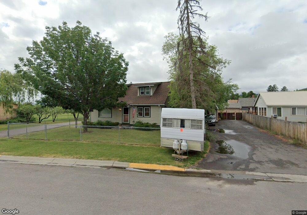
334 12th St W Kalispell, MT 59901
Estimated Value: $444,000 - $491,392
3
Beds
3
Baths
1,798
Sq Ft
$262/Sq Ft
Est. Value
About This Home
This home is located at 334 12th St W, Kalispell, MT 59901 and is currently estimated at $470,848, approximately $261 per square foot. 334 12th St W is a home located in Flathead County with nearby schools including Elrod School, Flathead High School, and St. Matthew's School.
Ownership History
Date
Name
Owned For
Owner Type
Purchase Details
Closed on
Jul 11, 2008
Sold by
Hebert Jerry
Bought by
Hunt Debra Sue
Current Estimated Value
Home Financials for this Owner
Home Financials are based on the most recent Mortgage that was taken out on this home.
Original Mortgage
$137,000
Outstanding Balance
$88,383
Interest Rate
6.07%
Mortgage Type
New Conventional
Estimated Equity
$382,465
Create a Home Valuation Report for This Property
The Home Valuation Report is an in-depth analysis detailing your home's value as well as a comparison with similar homes in the area
Home Values in the Area
Average Home Value in this Area
Purchase History
| Date | Buyer | Sale Price | Title Company |
|---|---|---|---|
| Hunt Debra Sue | -- | Insured Titles |
Source: Public Records
Mortgage History
| Date | Status | Borrower | Loan Amount |
|---|---|---|---|
| Open | Hunt Debra Sue | $137,000 |
Source: Public Records
Tax History Compared to Growth
Tax History
| Year | Tax Paid | Tax Assessment Tax Assessment Total Assessment is a certain percentage of the fair market value that is determined by local assessors to be the total taxable value of land and additions on the property. | Land | Improvement |
|---|---|---|---|---|
| 2025 | $2,301 | $454,700 | $0 | $0 |
| 2024 | $2,978 | $382,400 | $0 | $0 |
| 2023 | $3,534 | $382,400 | $0 | $0 |
| 2022 | $3,186 | $254,400 | $0 | $0 |
| 2021 | $2,737 | $254,400 | $0 | $0 |
| 2020 | $2,806 | $207,100 | $0 | $0 |
| 2019 | $2,807 | $207,100 | $0 | $0 |
| 2018 | $2,648 | $184,700 | $0 | $0 |
| 2017 | $2,652 | $184,700 | $0 | $0 |
| 2016 | $2,267 | $170,200 | $0 | $0 |
| 2015 | $2,262 | $170,200 | $0 | $0 |
| 2014 | $2,197 | $98,898 | $0 | $0 |
Source: Public Records
Map
Nearby Homes
- 209 12th St W
- 205 12th St W
- 1028 2nd Ave W
- 1517 5th Ave W
- 1418 6th Ave W
- 1313 7th Ave W
- 1308 7th Ave W
- 1483 & 1485 Western Dr
- 811 8th Ave W
- 1312 2nd Ave E
- 1225 2nd Ave E
- 824 8th St W
- 614 1st Ave W
- 819 9th Ave W
- 1814 N Belmar Dr
- 91 Denver Ave
- 1971 Bluestone Dr
- 330 12th St E
- 135 Rimrock Ct
- 815 3rd Ave E
- 1205 4th Ave W
- 1223 4th Ave W
- 1204 3rd Ave W
- 1145 4th Ave W
- 1225 4th Ave W
- 1138 3rd Ave W
- 1135 4th Ave W
- 1220 A & B 4th Ave W
- 1136 3rd Ave W
- 1204 4th Ave W
- 1127 4th Ave W
- 1144 4th Ave W
- 1224 4th Ave W
- 1128 3rd Ave W
- 1229 4th Ave W
- 1239 4th Ave W
- 1119 4th Ave W
- 258 12th St W
- 1126 3rd Ave W
- 1136 4th Ave W