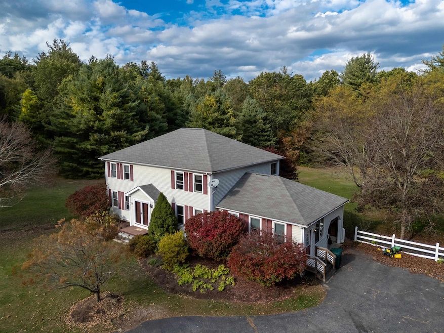
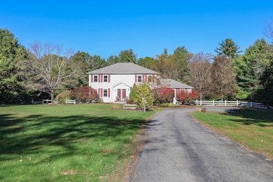
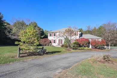
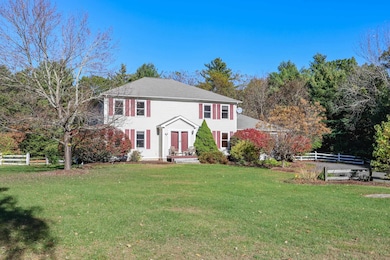
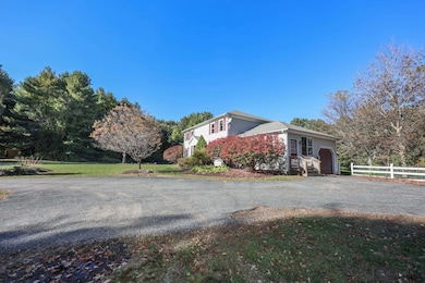
334 Broad St Hollis, NH 03049
Hollis NeighborhoodEstimated payment $5,517/month
Highlights
- Spa
- Sauna
- Colonial Architecture
- Hollis Primary School Rated A
- 6.29 Acre Lot
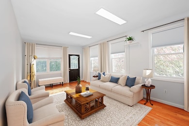
- Wood Flooring
About This Home
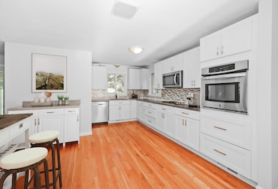
Set back from the road for privacy, this Classic Colonial offers comfort, space and a peaceful country setting. The main level features a living room with a fireplace, a den, formal dining room, spacious kitchen and a heated sunroom overlooking the backyard. Upstairs, the primary suite provides a private sanctuary complete with a spa-like shower and relaxing sauna. The two additional bedrooms share an appointed bath, offering space and convenience for family or guests. Additional highlights include hardwood floors, 2nd floor laundry and an attached one-car garage. Outside, the expansive grounds provide endless potential for outdoor entertaining, gardens, or future enhancements. Convenient Hollis location close to schools, shopping and restaurants.
Open House Schedule
-
Sunday, November 23, 202511:00 am to 12:30 pm11/23/2025 11:00:00 AM +00:0011/23/2025 12:30:00 PM +00:00Add to Calendar
Home Details
Home Type
- Single Family
Est. Annual Taxes
- $12,351
Year Built
- Built in 1996
Parking
- 1 Car Garage
- Dirt Driveway
Home Design
- Colonial Architecture
- Concrete Foundation
- Vinyl Siding
Interior Spaces
- Property has 2 Levels
- Dining Room
- Sun or Florida Room
- Sauna
- Basement
- Interior Basement Entry
Kitchen
- Microwave
- Dishwasher
Flooring
- Wood
- Ceramic Tile
- Vinyl Plank
Bedrooms and Bathrooms
- 3 Bedrooms
- En-Suite Primary Bedroom
Laundry
- Dryer
- Washer
Schools
- Hollis Primary Elementary School
- Hollis Brookline Middle Sch
- Hollis-Brookline High School
Utilities
- Forced Air Heating and Cooling System
- Drilled Well
- Leach Field
Additional Features
- Spa
- 6.29 Acre Lot
Listing and Financial Details
- Legal Lot and Block 2 / 49
- Assessor Parcel Number 26
Map
Home Values in the Area
Average Home Value in this Area
Tax History
| Year | Tax Paid | Tax Assessment Tax Assessment Total Assessment is a certain percentage of the fair market value that is determined by local assessors to be the total taxable value of land and additions on the property. | Land | Improvement |
|---|---|---|---|---|
| 2024 | $12,351 | $696,600 | $292,600 | $404,000 |
| 2023 | $11,605 | $696,600 | $292,600 | $404,000 |
| 2022 | $15,722 | $696,600 | $292,600 | $404,000 |
| 2021 | $10,192 | $449,000 | $205,400 | $243,600 |
| 2020 | $10,408 | $449,000 | $205,400 | $243,600 |
| 2019 | $10,182 | $440,800 | $205,400 | $235,400 |
| 2018 | $9,552 | $440,800 | $205,400 | $235,400 |
| 2017 | $9,123 | $394,100 | $168,000 | $226,100 |
| 2016 | $9,234 | $394,100 | $168,000 | $226,100 |
| 2015 | $9,118 | $396,100 | $168,000 | $228,100 |
| 2014 | $9,162 | $396,100 | $168,000 | $228,100 |
| 2013 | $9,039 | $396,100 | $168,000 | $228,100 |
Property History
| Date | Event | Price | List to Sale | Price per Sq Ft |
|---|---|---|---|---|
| 10/30/2025 10/30/25 | Price Changed | $849,995 | -8.1% | $272 / Sq Ft |
| 10/10/2025 10/10/25 | For Sale | $925,000 | -- | $296 / Sq Ft |
Purchase History
| Date | Type | Sale Price | Title Company |
|---|---|---|---|
| Warranty Deed | $470,000 | -- | |
| Deed | -- | -- |
Mortgage History
| Date | Status | Loan Amount | Loan Type |
|---|---|---|---|
| Open | $399,500 | Purchase Money Mortgage | |
| Previous Owner | $151,700 | Unknown | |
| Previous Owner | $136,000 | Unknown |
Source: PrimeMLS
MLS Number: 5065410
APN: HOLS-000026-000049-000002
Disclaimer: Certain information contained herein is derived from information provided by parties other than Homes.com. All information provided is deemed reliable, but is not guaranteed to be accurate and should be independently verified.
![]() Copyright 2025 PrimeMLS, Inc. All rights reserved. This information is deemed reliable, but not guaranteed. The data relating to real estate displayed on this display comes in part from the IDX Program of PrimeMLS. The information being provided is for consumers’ personal, non-commercial use and may not be used for any purpose other than to identify prospective properties consumers may be interested in purchasing.
Copyright 2025 PrimeMLS, Inc. All rights reserved. This information is deemed reliable, but not guaranteed. The data relating to real estate displayed on this display comes in part from the IDX Program of PrimeMLS. The information being provided is for consumers’ personal, non-commercial use and may not be used for any purpose other than to identify prospective properties consumers may be interested in purchasing.
- 28 Bartemus Trail Unit U210
- 76 Bartemus Trail Unit U231
- 22 Cathedral Cir
- 11 Bartemus Trail Unit 204
- 3 Richmond St
- 6 Cornwall Ln Unit 7
- 4 Nelson St
- 14 Parrish Hill Dr
- 46 Scenic Dr
- 5 Meghan Dr Unit U23
- 27 Country Hill Rd Unit U90
- 20 Martha St
- 199 Pine Hill Rd
- 424 Broad St
- 11 Inca Dr
- 4 Chesapeake Rd
- 40 Spring Cove Rd Unit U117
- 31 Spring Cove Rd Unit U148
- 12 Spring Cove Rd Unit U103
- 599 W Hollis St
- 5 Bartemus Trail Unit U202
- 4 Lowther Place Unit U5
- 28 Cortez Dr
- 53 Congress St
- 8 Newton Dr
- 26 Pittsburgh Dr
- 120 Flagstone Dr
- 15 Kingston Dr
- 6 Tanglewood Dr
- 3 Perry Ave
- 152 Cannongate 111 Rd
- 1 Hampshire Dr
- 2 Grand Ave Unit 7
- 15 N Intervale St
- 31 Cannongate III Unit 3
- 40 Squire Dr
- 101 W Hollis St Unit 2
- 28 Nagle St
- 32 Gilman St
- 24 Kessler Farm Dr
