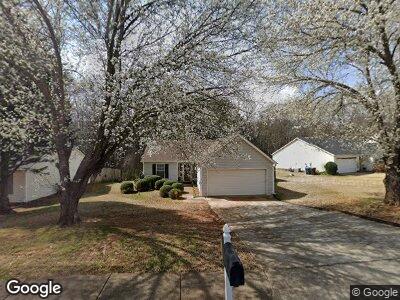
334 Brookside Dr Unit 1 McDonough, GA 30253
Estimated Value: $221,350 - $226,000
3
Beds
2
Baths
1,169
Sq Ft
$191/Sq Ft
Est. Value
About This Home
This home is located at 334 Brookside Dr Unit 1, McDonough, GA 30253 and is currently estimated at $223,838, approximately $191 per square foot. 334 Brookside Dr Unit 1 is a home located in Henry County with nearby schools including Oakland Elementary School, Eagle's Landing Middle School, and Eagle's Landing High School.
Ownership History
Date
Name
Owned For
Owner Type
Purchase Details
Closed on
Jul 15, 2003
Sold by
Richardson James B and Richardson Tammie R
Bought by
Richardson James E and Richardson Phyllis
Current Estimated Value
Purchase Details
Closed on
Feb 28, 1997
Sold by
Gt Arch Contr
Bought by
Richardson James Tammie
Create a Home Valuation Report for This Property
The Home Valuation Report is an in-depth analysis detailing your home's value as well as a comparison with similar homes in the area
Home Values in the Area
Average Home Value in this Area
Purchase History
| Date | Buyer | Sale Price | Title Company |
|---|---|---|---|
| Richardson James E | $103,300 | -- | |
| Richardson James Tammie | $83,000 | -- |
Source: Public Records
Mortgage History
| Date | Status | Borrower | Loan Amount |
|---|---|---|---|
| Previous Owner | Richardson James B | $104,500 | |
| Previous Owner | Richardson James B | $22,000 | |
| Closed | Richardson James Tammie | $0 |
Source: Public Records
Tax History Compared to Growth
Tax History
| Year | Tax Paid | Tax Assessment Tax Assessment Total Assessment is a certain percentage of the fair market value that is determined by local assessors to be the total taxable value of land and additions on the property. | Land | Improvement |
|---|---|---|---|---|
| 2024 | $3,183 | $84,640 | $14,000 | $70,640 |
| 2023 | $3,322 | $88,360 | $12,000 | $76,360 |
| 2022 | $2,553 | $66,200 | $12,000 | $54,200 |
| 2021 | $1,975 | $50,000 | $12,000 | $38,000 |
| 2020 | $1,820 | $45,760 | $8,000 | $37,760 |
| 2019 | $1,732 | $42,280 | $8,000 | $34,280 |
| 2018 | $1,509 | $36,720 | $7,200 | $29,520 |
| 2016 | $1,299 | $31,120 | $7,200 | $23,920 |
| 2015 | -- | $28,080 | $7,200 | $20,880 |
| 2014 | $1,096 | $25,560 | $6,000 | $19,560 |
Source: Public Records
Map
Nearby Homes
- 1199 Village Dr
- 173 Regency Park Dr
- 175 Regency Park Dr Unit 3
- 1637 Fuma Leaf Way
- 201 Coral Cir
- 128 Prity Ct
- 132 Prity Ct
- 371 Coral Cir
- 241 Coral Cir
- 608 Pelican Place
- 419 Kara Ln
- 256 Coral Cir
- 261 Coral Cir
- 263 Coral Cir
- 433 Kara Ln
- 444 Kara Ln
- 449 Kara Ln
- 309 Coral Cir
- 311 Quincy Ave
- 187 London Dr
- 334 Brookside Dr Unit 1
- 336 Brookside Dr Unit 1
- 332 Brookside Dr Unit 1
- 330 Brookside Dr Unit 330
- 330 Brookside Dr
- 330 Brookside Dr
- 338 Brookside Dr
- 333 Brookside Dr
- 335 Brookside Dr
- 335 Brookside Dr
- 340 Brookside Dr
- 331 Brookside Dr
- 331 Brookside Dr Unit 2
- 337 Brookside Dr
- 328 Brookside Dr
- 329 Brookside Dr Unit 1
- 342 Brookside Dr Unit 41
- 342 Brookside Dr
- 339 Brookside Dr Unit 1
- 341 Brookside Dr
