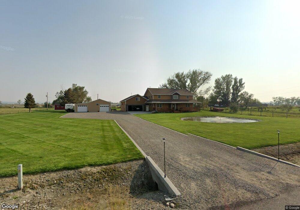
3350 Homer Davis Rd Shepherd, MT 59079
Estimated Value: $584,000 - $725,000
3
Beds
4
Baths
3,352
Sq Ft
$202/Sq Ft
Est. Value
About This Home
This home is located at 3350 Homer Davis Rd, Shepherd, MT 59079 and is currently estimated at $675,550, approximately $201 per square foot. 3350 Homer Davis Rd is a home located in Yellowstone County with nearby schools including Shepherd Elementary School, Shepherd Middle School, and Shepherd High School.
Ownership History
Date
Name
Owned For
Owner Type
Purchase Details
Closed on
May 3, 2010
Sold by
Kiekover Robert
Bought by
Kiekover Michael S
Current Estimated Value
Purchase Details
Closed on
Apr 29, 2010
Sold by
Kiekover Deborah J
Bought by
Kiekover Michael S
Purchase Details
Closed on
Dec 1, 2006
Sold by
The Bank Of New York
Bought by
Kiekover Michael S and Kieckover Deborah J
Purchase Details
Closed on
Aug 8, 2006
Sold by
Bookout Roy R and Bookout Kathryn
Bought by
The Bank Of New York
Create a Home Valuation Report for This Property
The Home Valuation Report is an in-depth analysis detailing your home's value as well as a comparison with similar homes in the area
Purchase History
| Date | Buyer | Sale Price | Title Company |
|---|---|---|---|
| Kiekover Michael S | -- | St | |
| Kiekover Michael S | -- | St | |
| Kiekover Michael S | -- | None Available | |
| The Bank Of New York | $58,125 | None Available |
Source: Public Records
Tax History
| Year | Tax Paid | Tax Assessment Tax Assessment Total Assessment is a certain percentage of the fair market value that is determined by local assessors to be the total taxable value of land and additions on the property. | Land | Improvement |
|---|---|---|---|---|
| 2025 | $5,738 | $695,900 | $148,849 | $547,051 |
| 2024 | $5,738 | $678,900 | $104,463 | $574,437 |
| 2023 | $5,839 | $678,900 | $104,463 | $574,437 |
| 2022 | $4,603 | $489,500 | $0 | $0 |
| 2021 | $4,732 | $489,500 | $0 | $0 |
| 2020 | $4,256 | $424,300 | $0 | $0 |
| 2019 | $3,520 | $424,300 | $0 | $0 |
| 2018 | $3,797 | $431,700 | $0 | $0 |
| 2017 | $3,726 | $431,700 | $0 | $0 |
| 2016 | $3,630 | $439,200 | $0 | $0 |
| 2015 | $3,600 | $439,200 | $0 | $0 |
| 2014 | $2,718 | $176,066 | $0 | $0 |
Source: Public Records
Map
Nearby Homes
- 6634 Killdeer Ln
- 3418 High Noon
- L3B2 High Noon Dr
- L9B2 Rio Lobo Cir
- L11B2 Rio Lobo Cir
- TBD High Noon Dr
- L6B2 High Noon Dr
- 3514 High Noon
- L8B2 High Noon Dr
- L1B1 High Noon Dr
- L2B1 High Noon Dr
- L12B2 High Noon Dr
- 3507 High Noon
- L6B3 High Noon Dr
- L13B2 High Noon Dr
- L10B3 High Noon Dr
- L8B3 High Noon Dr
- L11B3 High Noon Dr
- L2B3 Molly Dr W
- L1B3 Molly Dr W
- 3346 Homer Davis Rd
- 3234 Homer Davis Rd
- 1 Homer Davis Rd
- 0 Homer Davis Rd
- 3605 Homer Davis Rd
- 3608 Homer Davis Rd
- 3215 Homer Davis Rd
- 0 Larimer Ln Unit 294470
- 0 Larimer Ln Unit 304117
- 3027 Homer Davis Rd
- 3625 Homer Davis Rd
- 3645 Homer Davis Rd
- 5969 Larimer Ln
- 6512 Martell Ln
- 17 Martell Ln
- 6427 Martell Ln
- 3614 Plains Dr
- 6407 Martell Ln
- 6403 Martell Ln
- 3607 Plains Dr
Your Personal Tour Guide
Ask me questions while you tour the home.