J
Seller's Agent in 2019
Joey Purpura
Midwest Land Group


Estimated Value: $253,000
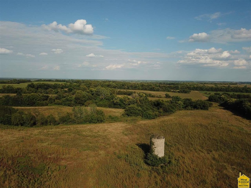
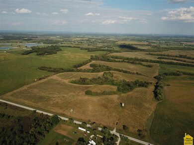
: Located just North of Drexel Missouri on State Route D, this 80 acre tract has a lot to offer. With roughly 60 tillable acres, the property has been farmed for the last 20 years. The property was not farmed in 2018 and will be ready to be sown to grass or farmed again this coming season. Although it is almost 75% tillable, the way that the elevation change and wooded draws run through the property give it a very secluded feel. There are two secluded draws in the furthest West draw that provide excellent water access to the wildlife that call the property home. Deer sign is littered throughout the property and with the current vegetation growth, surrounded by corn and beans, this property is holding a lot of deer. The potential to put secluded food plots in, possibly enroll the ground in CRP, and sow the fields to grass are just a few of the possibilities on this property. At just 45 minutes from Lee’s Summit, Overland Park, and South KC, and 25 minutes from Harrisonville, the location is top notch. With paved road frontage, rural water and electric available, this property would make an excellent home site with the potential to have a view with no houses back off of the road. Don’t miss the chance to take a look at a property with great recreational potential, location, and more!
Last Agent to Sell the Property
Joey Purpura
Midwest Land Group License #2016007880 Listed on: 10/09/2018
Last Buyer's Agent
Non Member Non Member
Non Member Office
| Date | Event | Price | List to Sale | Price per Sq Ft |
|---|---|---|---|---|
| 02/15/2019 02/15/19 | Sold | -- | -- | -- |
| 10/09/2018 10/09/18 | For Sale | $255,900 | -- | -- |
| Year | Tax Paid | Tax Assessment Tax Assessment Total Assessment is a certain percentage of the fair market value that is determined by local assessors to be the total taxable value of land and additions on the property. | Land | Improvement |
|---|---|---|---|---|
| 2025 | $131 | $1,810 | $1,810 | -- |
| 2024 | $131 | $1,810 | $1,810 | -- |
| 2023 | $130 | $1,810 | $1,810 | $0 |
| 2022 | $127 | $1,810 | $1,810 | $0 |
| 2021 | $119 | $1,810 | $1,810 | $0 |
| 2020 | $119 | $1,810 | $1,810 | $0 |
| 2019 | $117 | $1,810 | $1,810 | $0 |
| 2018 | $127 | $1,950 | $1,950 | $0 |
| 2017 | -- | $1,950 | $1,950 | $0 |
| 2016 | $128 | $1,950 | $1,950 | $0 |
| 2015 | -- | $1,950 | $1,950 | $0 |
| 2014 | -- | $1,850 | $1,850 | $0 |
| 2013 | -- | $1,850 | $1,850 | $0 |
J
Seller's Agent in 2019
Joey Purpura
Midwest Land Group
N
Buyer's Agent in 2019
Non Member Non Member
Non Member Office
Source: West Central Association of REALTORS® (MO)
MLS Number: 81991
APN: 0444300
Disclaimer: Certain information contained herein is derived from information provided by parties other than Homes.com. All information provided is deemed reliable, but is not guaranteed to be accurate and should be independently verified.
![]() IDX information is provided exclusively for personal, non-commercial use, and may not be used for any purpose other than to identify prospective properties consumers may be interested in purchasing. Information is deemed reliable but not guaranteed.
IDX information is provided exclusively for personal, non-commercial use, and may not be used for any purpose other than to identify prospective properties consumers may be interested in purchasing. Information is deemed reliable but not guaranteed.
Ask me questions while you tour the home.