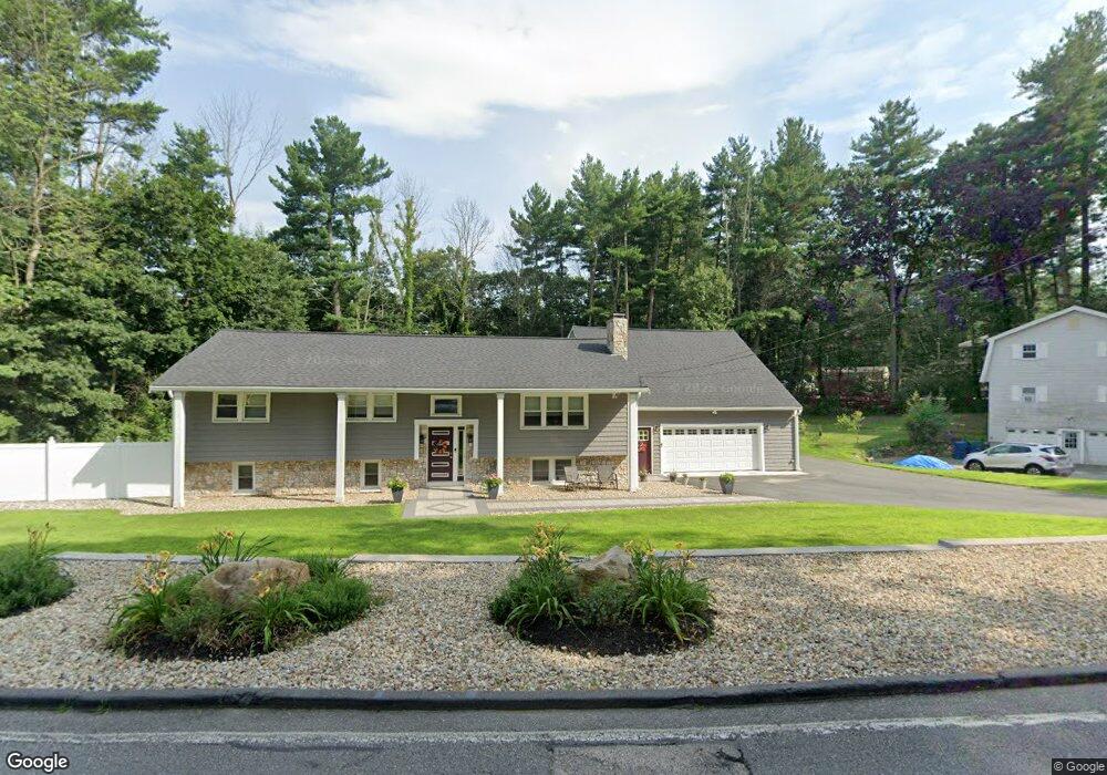
337 Kendall Rd Tewksbury, MA 01876
Estimated Value: $790,120 - $887,000
5
Beds
2
Baths
1,300
Sq Ft
$639/Sq Ft
Est. Value
About This Home
This home is located at 337 Kendall Rd, Tewksbury, MA 01876 and is currently estimated at $830,780, approximately $639 per square foot. 337 Kendall Rd is a home located in Middlesex County with nearby schools including John F. Ryan Elementary School, John W. Wynn Middle School, and Tewksbury Memorial High School.
Ownership History
Date
Name
Owned For
Owner Type
Purchase Details
Closed on
Apr 10, 2006
Sold by
Difruscia Karen Mccann
Bought by
Aa Rt and Mccann-Difruscia Karen
Current Estimated Value
Purchase Details
Closed on
Nov 1, 1996
Sold by
Hittle Thomas H and Hittle Maria
Bought by
Difruscia Marc A and Difruscia Karen
Home Financials for this Owner
Home Financials are based on the most recent Mortgage that was taken out on this home.
Original Mortgage
$150,000
Interest Rate
7.55%
Purchase Details
Closed on
Sep 24, 1993
Sold by
Hinsman Kenneth S and Hinsman Juliette
Bought by
Hittle Thomas H and Hittle Maria R
Create a Home Valuation Report for This Property
The Home Valuation Report is an in-depth analysis detailing your home's value as well as a comparison with similar homes in the area
Home Values in the Area
Average Home Value in this Area
Purchase History
| Date | Buyer | Sale Price | Title Company |
|---|---|---|---|
| Aa Rt | -- | -- | |
| Difruscia Marc A | $223,000 | -- | |
| Hittle Thomas H | $184,000 | -- |
Source: Public Records
Mortgage History
| Date | Status | Borrower | Loan Amount |
|---|---|---|---|
| Open | Hittle Thomas H | $25,000 | |
| Previous Owner | Hittle Thomas H | $175,000 | |
| Previous Owner | Hittle Thomas H | $150,000 | |
| Previous Owner | Hittle Thomas H | $143,900 |
Source: Public Records
Tax History Compared to Growth
Tax History
| Year | Tax Paid | Tax Assessment Tax Assessment Total Assessment is a certain percentage of the fair market value that is determined by local assessors to be the total taxable value of land and additions on the property. | Land | Improvement |
|---|---|---|---|---|
| 2025 | $9,127 | $690,400 | $321,800 | $368,600 |
| 2024 | $8,866 | $662,100 | $306,500 | $355,600 |
| 2023 | $8,859 | $628,300 | $278,500 | $349,800 |
| 2022 | $8,468 | $557,100 | $242,300 | $314,800 |
| 2021 | $8,054 | $518,900 | $220,500 | $298,400 |
| 2020 | $8,023 | $502,400 | $210,100 | $292,300 |
| 2019 | $7,385 | $466,200 | $200,100 | $266,100 |
| 2018 | $7,108 | $440,700 | $200,100 | $240,600 |
| 2017 | $6,793 | $416,500 | $200,100 | $216,400 |
| 2016 | $6,532 | $399,500 | $200,100 | $199,400 |
| 2015 | $6,194 | $378,400 | $190,500 | $187,900 |
| 2014 | $5,982 | $371,300 | $190,500 | $180,800 |
Source: Public Records
Map
Nearby Homes
- 68 Catamount Rd
- 20 Meredith Rd
- 1170 Livingston St
- 399 North St
- 139 Prospect Hill Dr Unit Lot 15
- 101 Bellevue Rd
- 51 Nolan Ct Unit 51
- 69 Blanchard St
- 58 Blanchard St
- 22 Haggetts Pond Rd
- 1117 Emerald Ct
- 11 Emerald Ct
- 1224 Emerald Ct
- 7 Stouffer Cir
- 120 Judique Rd
- 13 Berkeley
- 5 Kensington Way Unit 5
- 14 Geneva Rd
- 15 Geneva Rd
- 110 Royal Crest Cir
- 313 Kendall Rd
- 351 Kendall Rd
- 350 Kendall Rd
- 10 Overlook Dr
- 312 Kendall Rd
- 289 Kendall Rd
- 375 Kendall Rd
- 370 Kendall Rd
- 302 Kendall Rd
- 20 Overlook Dr
- 265 Kendall Rd
- 292 Kendall Rd
- 31 Overlook Dr
- 399 Kendall Rd
- 14 Pennacook Rd
- 390 Kendall Rd
- 30 Overlook Dr
- 282 Kendall Rd
- 24 Pennacook Rd
- 251 Kendall Rd