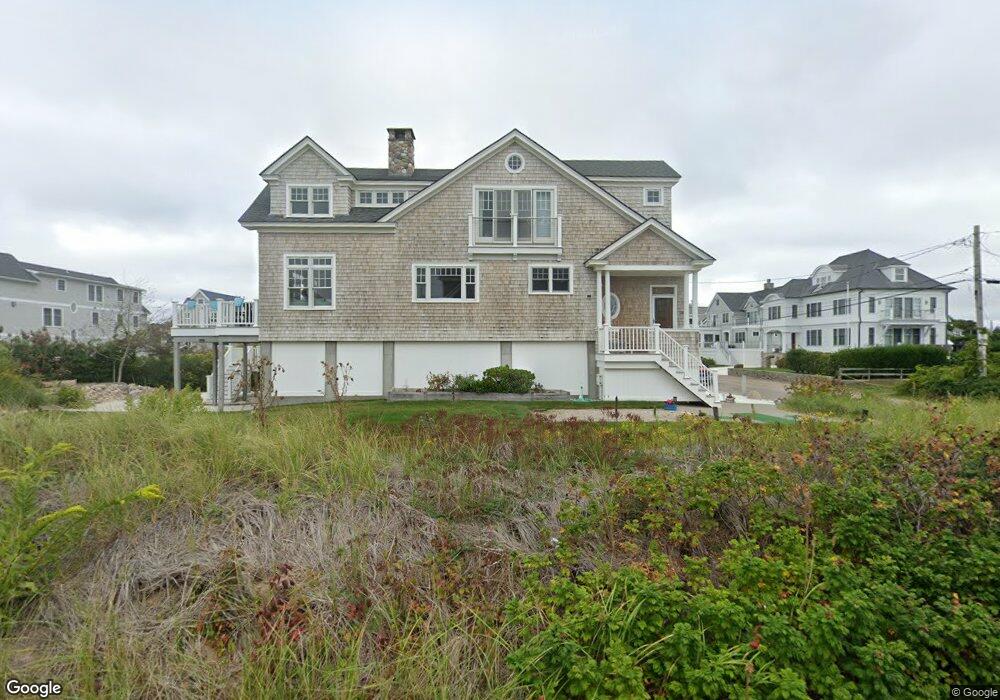
34 Atlantic Ave Westerly, RI 02891
Estimated Value: $1,890,000 - $3,125,000
3
Beds
4
Baths
3,162
Sq Ft
$746/Sq Ft
Est. Value
About This Home
This home is located at 34 Atlantic Ave, Westerly, RI 02891 and is currently estimated at $2,359,065, approximately $746 per square foot. 34 Atlantic Ave is a home located in Washington County with nearby schools including Westerly High School.
Ownership History
Date
Name
Owned For
Owner Type
Purchase Details
Closed on
May 5, 2023
Sold by
Nevins Linda and Nevins Frank W
Bought by
F
Current Estimated Value
Purchase Details
Closed on
Sep 13, 2018
Sold by
Westerly Ri Props Llc
Bought by
Nevins Linda and Nevins Frank W
Purchase Details
Closed on
Dec 10, 2010
Sold by
Nevins Frank W
Bought by
Westerly Ri Props
Create a Home Valuation Report for This Property
The Home Valuation Report is an in-depth analysis detailing your home's value as well as a comparison with similar homes in the area
Home Values in the Area
Average Home Value in this Area
Purchase History
| Date | Buyer | Sale Price | Title Company |
|---|---|---|---|
| F | -- | None Available | |
| Nevins Linda | -- | -- | |
| Westerly Ri Props | -- | -- | |
| Nevins Frank W | -- | -- | |
| Koltz S Nancy Irt | $250,000 | -- |
Source: Public Records
Tax History
| Year | Tax Paid | Tax Assessment Tax Assessment Total Assessment is a certain percentage of the fair market value that is determined by local assessors to be the total taxable value of land and additions on the property. | Land | Improvement |
|---|---|---|---|---|
| 2025 | $14,804 | $2,082,100 | $1,218,700 | $863,400 |
| 2024 | $15,330 | $1,562,700 | $867,200 | $695,500 |
| 2023 | $15,033 | $1,562,700 | $867,200 | $695,500 |
| 2022 | $14,939 | $1,562,700 | $867,200 | $695,500 |
| 2021 | $13,658 | $1,185,600 | $629,400 | $556,200 |
| 2020 | $13,409 | $1,185,600 | $629,400 | $556,200 |
| 2019 | $13,279 | $1,185,600 | $629,400 | $556,200 |
| 2018 | $12,739 | $1,072,300 | $572,300 | $500,000 |
| 2017 | $12,428 | $1,072,300 | $572,300 | $500,000 |
| 2016 | $12,524 | $1,072,300 | $572,300 | $500,000 |
| 2015 | $11,889 | $1,098,800 | $583,900 | $514,900 |
| 2014 | $11,691 | $1,098,800 | $583,900 | $514,900 |
Source: Public Records
Map
Nearby Homes
- 27 Benson Ave
- 10 Tristam St
- 4 Shore Rd
- 4 Quail Run
- 109 Watch Hill Rd
- 20 Browning Rd
- 9 Compass Way Unit 201
- 9 Compass Way Unit 202
- 9 Compass Way Unit 101
- 9 Compass Way Unit 102
- 9 Compass Way Unit 103
- 9 Compass Way Unit 203
- 52 Avondale Rd
- 9 Champlin Dr
- 60 Avondale Rd
- 417 River Rd
- 18 Timothy Dr
- 432 Atlantic Ave
- 16 Green Ave
- 446 Atlantic Ave
- 32 Atlantic Ave
- 37 Atlantic Ave
- 35 Atlantic Ave
- 1 Maplewood Ave
- 4 Maplewood Ave
- 41 Atlantic Ave
- 44 Atlantic Ave
- 3 Maplewood Ave
- 1 Dogwood Ave
- 33 Atlantic Ave
- 6 Maplewood Ave
- 45 Atlantic Ave
- 31 Atlantic Ave
- 46 Atlantic Ave
- 47 Atlantic Ave
- 5 Maplewood Ave
- 4 Dogwood Ave
- 10 Maplewood Ave
- 25 Atlantic Ave
- 5 Atlantic Ave
Your Personal Tour Guide
Ask me questions while you tour the home.