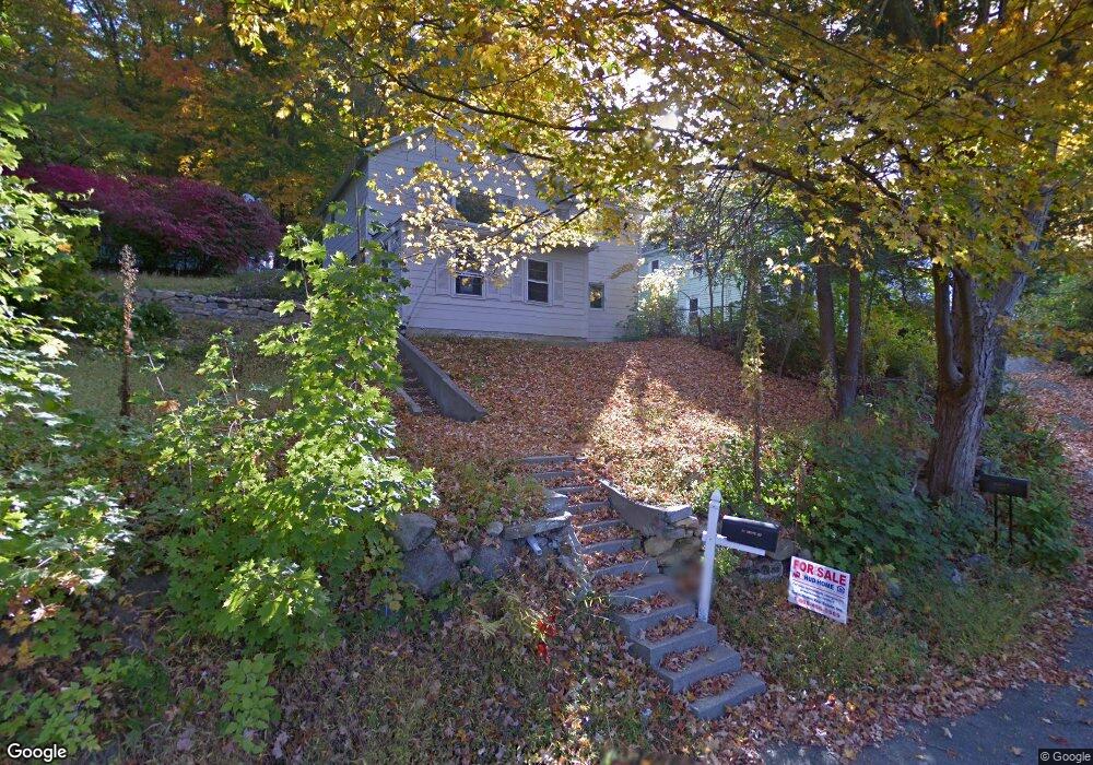
34 Grove St Palmer, MA 01069
Estimated Value: $139,000 - $265,327
3
Beds
1
Bath
1,128
Sq Ft
$206/Sq Ft
Est. Value
About This Home
This home is located at 34 Grove St, Palmer, MA 01069 and is currently estimated at $232,332, approximately $205 per square foot. 34 Grove St is a home located in Hampden County with nearby schools including Old Mill Pond Elementary School, Converse Middle School, and Palmer High School.
Ownership History
Date
Name
Owned For
Owner Type
Purchase Details
Closed on
Jun 18, 2014
Sold by
Department Of Housing & Urban Dev
Bought by
Kaja Holdings 2 Llc
Current Estimated Value
Purchase Details
Closed on
Aug 2, 2013
Sold by
Midfirst Bank Ssb
Bought by
Department Of Housing & Urban Dev
Purchase Details
Closed on
Jul 3, 2013
Sold by
Clark Paul D and Midfirst Bank State Sb
Bought by
Midfirst Bank State Sb
Purchase Details
Closed on
Feb 16, 2007
Sold by
Coates Daniel W and Coates Judith
Bought by
Clark Paul D and Clark Chandra R
Home Financials for this Owner
Home Financials are based on the most recent Mortgage that was taken out on this home.
Original Mortgage
$136,314
Interest Rate
6.24%
Mortgage Type
Purchase Money Mortgage
Create a Home Valuation Report for This Property
The Home Valuation Report is an in-depth analysis detailing your home's value as well as a comparison with similar homes in the area
Home Values in the Area
Average Home Value in this Area
Purchase History
| Date | Buyer | Sale Price | Title Company |
|---|---|---|---|
| Kaja Holdings 2 Llc | $33,600 | -- | |
| Department Of Housing & Urban Dev | -- | -- | |
| Department Of Housing & Urban Dev | -- | -- | |
| Midfirst Bank State Sb | $152,222 | -- | |
| Midfirst Bank State Sb | $152,222 | -- | |
| Clark Paul D | $138,500 | -- | |
| Clark Paul D | $138,500 | -- |
Source: Public Records
Mortgage History
| Date | Status | Borrower | Loan Amount |
|---|---|---|---|
| Previous Owner | Clark Paul D | $136,314 | |
| Previous Owner | Clark Paul D | $20,000 |
Source: Public Records
Tax History Compared to Growth
Tax History
| Year | Tax Paid | Tax Assessment Tax Assessment Total Assessment is a certain percentage of the fair market value that is determined by local assessors to be the total taxable value of land and additions on the property. | Land | Improvement |
|---|---|---|---|---|
| 2025 | $2,889 | $159,200 | $48,000 | $111,200 |
| 2024 | $2,685 | $143,800 | $43,700 | $100,100 |
| 2023 | $2,622 | $134,900 | $43,700 | $91,200 |
| 2022 | $2,594 | $121,200 | $38,300 | $82,900 |
| 2021 | $2,548 | $112,600 | $42,400 | $70,200 |
| 2020 | $2,483 | $108,900 | $42,400 | $66,500 |
| 2019 | $2,411 | $108,900 | $42,400 | $66,500 |
| 2018 | $2,336 | $105,800 | $41,200 | $64,600 |
| 2017 | $2,282 | $105,800 | $41,200 | $64,600 |
| 2016 | $2,187 | $102,800 | $40,000 | $62,800 |
| 2015 | $2,121 | $102,800 | $40,000 | $62,800 |
Source: Public Records
Map
Nearby Homes
- 1018-1020 Maple St
- 44 Converse St
- 160 Breckenridge St
- 72 Quaboag Valley Co Op St Unit 70
- 207 Breckenridge St
- L 65-35-1 Pine Hill Dr
- Lot 8 Breckenridge St
- 0 St Unit 73414881
- Lot 0 Thorndike and Lawrence St
- 62-91 Lawrence St
- Lots 39-42 Lawrence
- 11 Allen St
- 1415 Park St
- 268 Palmer Rd Unit 59
- 268 Palmer Rd Unit 44
- 268 Palmer Rd Unit 27
- 268 Palmer Rd Unit 2
- 1029 Wilson St
- 0 Flynt St
- 1682 N Main St