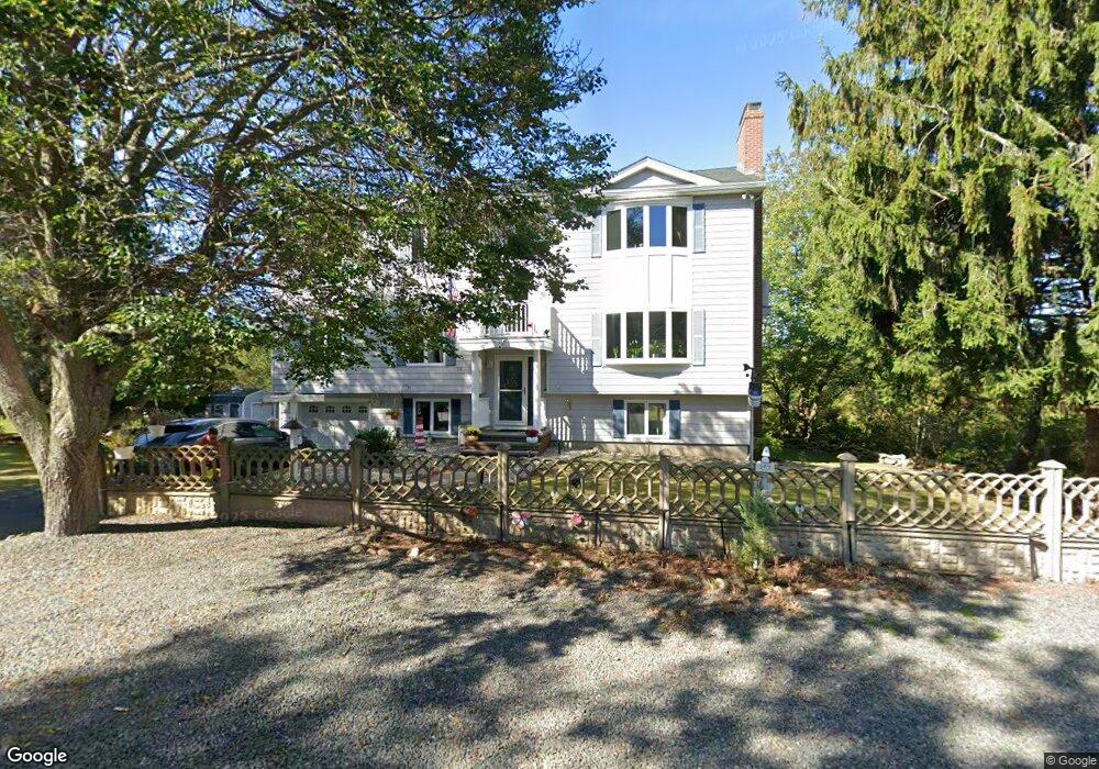
34 High Popples Rd Gloucester, MA 01930
East Gloucester NeighborhoodEstimated Value: $1,048,000 - $1,344,000
3
Beds
2
Baths
2,200
Sq Ft
$553/Sq Ft
Est. Value
About This Home
This home is located at 34 High Popples Rd, Gloucester, MA 01930 and is currently estimated at $1,217,644, approximately $553 per square foot. 34 High Popples Rd is a home located in Essex County with nearby schools including East Gloucester Elementary School, Ralph B O'maley Middle School, and Gloucester High School.
Ownership History
Date
Name
Owned For
Owner Type
Purchase Details
Closed on
Oct 29, 1999
Sold by
Lamont Paul R and Lamont Kathy M
Bought by
Schuster Michael R and Schuster Heidi A
Current Estimated Value
Home Financials for this Owner
Home Financials are based on the most recent Mortgage that was taken out on this home.
Original Mortgage
$240,000
Outstanding Balance
$73,438
Interest Rate
7.78%
Mortgage Type
Purchase Money Mortgage
Estimated Equity
$1,144,206
Purchase Details
Closed on
Mar 1, 1995
Sold by
Curreri Agatha
Bought by
Lamont Paul R
Home Financials for this Owner
Home Financials are based on the most recent Mortgage that was taken out on this home.
Original Mortgage
$140,000
Interest Rate
8.96%
Mortgage Type
Purchase Money Mortgage
Create a Home Valuation Report for This Property
The Home Valuation Report is an in-depth analysis detailing your home's value as well as a comparison with similar homes in the area
Home Values in the Area
Average Home Value in this Area
Purchase History
| Date | Buyer | Sale Price | Title Company |
|---|---|---|---|
| Schuster Michael R | $272,000 | -- | |
| Lamont Paul R | $205,000 | -- |
Source: Public Records
Mortgage History
| Date | Status | Borrower | Loan Amount |
|---|---|---|---|
| Open | Schuster Michael R | $240,000 | |
| Previous Owner | Lamont Paul R | $141,600 | |
| Previous Owner | Lamont Paul R | $140,000 |
Source: Public Records
Tax History
| Year | Tax Paid | Tax Assessment Tax Assessment Total Assessment is a certain percentage of the fair market value that is determined by local assessors to be the total taxable value of land and additions on the property. | Land | Improvement |
|---|---|---|---|---|
| 2025 | $9,990 | $1,027,800 | $292,400 | $735,400 |
| 2024 | $9,864 | $1,013,800 | $278,400 | $735,400 |
| 2023 | $9,440 | $891,400 | $248,500 | $642,900 |
| 2022 | $9,090 | $774,900 | $211,200 | $563,700 |
| 2021 | $8,779 | $705,700 | $192,100 | $513,600 |
| 2020 | $8,812 | $714,700 | $192,100 | $522,600 |
| 2019 | $8,515 | $671,000 | $192,100 | $478,900 |
| 2018 | $8,283 | $640,600 | $192,100 | $448,500 |
| 2017 | $8,088 | $613,200 | $182,900 | $430,300 |
| 2016 | $7,857 | $577,300 | $183,400 | $393,900 |
| 2015 | $7,472 | $547,400 | $183,400 | $364,000 |
Source: Public Records
Map
Nearby Homes
- 10 Seaview Rd
- 11 Ocean View Dr
- 197 E Main St Unit 1
- 15 Raven Ln Unit 15
- 1 Wonson St
- 73 Rocky Neck Ave Unit 2
- 60 Rocky Neck Ave Unit 202
- 70 Bass Ave
- 3 Mondello Square
- 5 Wise Place
- 191 Main St Unit 3
- 191 Main St Unit 2A
- 139A Prospect St
- 14R Spring St Unit 3
- 36 Eastern Ave
- 100 Eastern Point Blvd
- 26 Marina Dr
- 35 Middle St Unit 4
- 33 Middle St
- 50 Warner St
- 32 High Popples Rd
- 14 Lands End Ln
- 35 High Popples Rd
- 31 High Popples Rd
- 12 Lands End Ln
- 11 Lands End Ln
- 29 High Popples Rd
- 28 High Popples Rd
- 2 Michaels Ln
- 10 Lands End Ln
- 1 Fairmount Rd
- 4 Michaels Ln
- 9 Lands End Ln
- 14 Harriett Rd
- 26 High Popples Rd
- 12 Harriett Rd
- 3 Fairmount Rd
- 5 Michaels Ln
- 6 Michaels Ln
- 24 High Popples Rd
Your Personal Tour Guide
Ask me questions while you tour the home.