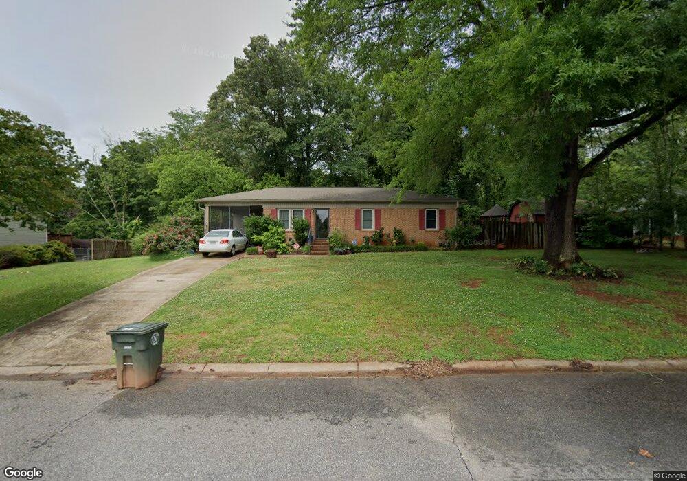
34 Maple Ct Newton, NC 28658
Estimated Value: $219,000 - $255,000
4
Beds
1
Bath
1,253
Sq Ft
$183/Sq Ft
Est. Value
About This Home
This home is located at 34 Maple Ct, Newton, NC 28658 and is currently estimated at $229,823, approximately $183 per square foot. 34 Maple Ct is a home located in Catawba County with nearby schools including Startown Elementary School, Maiden Middle School, and Maiden High School.
Ownership History
Date
Name
Owned For
Owner Type
Purchase Details
Closed on
Feb 8, 2012
Sold by
Green Tree Servicing Llc
Bought by
Abernathy Barbara A
Current Estimated Value
Home Financials for this Owner
Home Financials are based on the most recent Mortgage that was taken out on this home.
Original Mortgage
$132,213
Outstanding Balance
$90,579
Interest Rate
3.89%
Mortgage Type
Seller Take Back
Estimated Equity
$139,244
Purchase Details
Closed on
Mar 26, 2003
Bought by
Abernathy Barbara A
Purchase Details
Closed on
Mar 1, 1981
Create a Home Valuation Report for This Property
The Home Valuation Report is an in-depth analysis detailing your home's value as well as a comparison with similar homes in the area
Home Values in the Area
Average Home Value in this Area
Purchase History
| Date | Buyer | Sale Price | Title Company |
|---|---|---|---|
| Abernathy Barbara A | $51,000 | None Available | |
| Abernathy Barbara A | $92,000 | -- | |
| -- | $33,000 | -- |
Source: Public Records
Mortgage History
| Date | Status | Borrower | Loan Amount |
|---|---|---|---|
| Open | Abernathy Barbara A | $132,213 |
Source: Public Records
Tax History
| Year | Tax Paid | Tax Assessment Tax Assessment Total Assessment is a certain percentage of the fair market value that is determined by local assessors to be the total taxable value of land and additions on the property. | Land | Improvement |
|---|---|---|---|---|
| 2025 | $1,489 | $197,800 | $10,000 | $187,800 |
| 2024 | $1,489 | $175,500 | $10,000 | $165,500 |
| 2023 | $1,489 | $175,500 | $10,000 | $165,500 |
| 2022 | $1,132 | $101,500 | $10,000 | $91,500 |
| 2021 | $1,132 | $101,500 | $10,000 | $91,500 |
| 2020 | $1,132 | $101,500 | $10,000 | $91,500 |
| 2019 | $1,132 | $101,500 | $0 | $0 |
| 2018 | $1,073 | $96,200 | $10,300 | $85,900 |
| 2017 | $1,073 | $0 | $0 | $0 |
| 2016 | $1,073 | $0 | $0 | $0 |
| 2015 | $933 | $96,200 | $10,300 | $85,900 |
| 2014 | $933 | $92,400 | $10,900 | $81,500 |
Source: Public Records
Map
Nearby Homes
- 10 Maple Ct
- 1312 Oak Hill Dr
- 1610 Summerlin Place
- 1625 Summerlin Place
- 1512 N Deal Ave
- 1118 N Frye Ave
- 503 W 12th St
- 660 W 9th St
- 885 W 25th St
- 2102 Old Conover-Startown Rd
- 210 W 15th St
- 856 W 6th Street Cir
- 902 N Ashe Ave
- 803 W 1st St
- 1208 N Davis Ave
- 552 Dazzle Loop
- 544 Dazzle Loop
- 564 Dazzle Loop
- 536 Dazzle Loop
- 572 Dazzle Loop
Your Personal Tour Guide
Ask me questions while you tour the home.