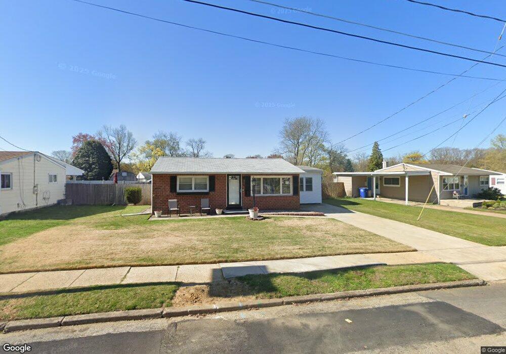
34 Merion Ln Maple Shade, NJ 08052
Estimated Value: $256,000 - $309,000
--
Bed
--
Bath
1,013
Sq Ft
$276/Sq Ft
Est. Value
About This Home
This home is located at 34 Merion Ln, Maple Shade, NJ 08052 and is currently estimated at $279,421, approximately $275 per square foot. 34 Merion Ln is a home located in Burlington County with nearby schools including Ralph J Steinhauer Elementary School, Maude M. Wilkins Elementary School, and Howard R Yocum School.
Ownership History
Date
Name
Owned For
Owner Type
Purchase Details
Closed on
Dec 20, 2002
Sold by
Pengelly Deborah Ann
Bought by
Forant Frank J and Forant Donna D
Current Estimated Value
Home Financials for this Owner
Home Financials are based on the most recent Mortgage that was taken out on this home.
Original Mortgage
$117,075
Outstanding Balance
$50,072
Interest Rate
6.18%
Estimated Equity
$229,349
Purchase Details
Closed on
Jul 26, 1994
Sold by
Pengelly Gordon H
Bought by
Pengelly Gordon H and Pengelly Deborah
Create a Home Valuation Report for This Property
The Home Valuation Report is an in-depth analysis detailing your home's value as well as a comparison with similar homes in the area
Home Values in the Area
Average Home Value in this Area
Purchase History
| Date | Buyer | Sale Price | Title Company |
|---|---|---|---|
| Forant Frank J | $118,000 | Fidelity Title Abstract Co | |
| Pengelly Gordon H | -- | -- |
Source: Public Records
Mortgage History
| Date | Status | Borrower | Loan Amount |
|---|---|---|---|
| Open | Forant Frank J | $117,075 |
Source: Public Records
Tax History Compared to Growth
Tax History
| Year | Tax Paid | Tax Assessment Tax Assessment Total Assessment is a certain percentage of the fair market value that is determined by local assessors to be the total taxable value of land and additions on the property. | Land | Improvement |
|---|---|---|---|---|
| 2025 | $4,992 | $131,500 | $49,500 | $82,000 |
| 2024 | $4,847 | $131,500 | $49,500 | $82,000 |
| 2023 | $4,847 | $131,500 | $49,500 | $82,000 |
| 2022 | $4,772 | $131,500 | $49,500 | $82,000 |
| 2021 | $4,726 | $131,500 | $49,500 | $82,000 |
| 2020 | $4,739 | $131,500 | $49,500 | $82,000 |
| 2019 | $4,566 | $131,500 | $49,500 | $82,000 |
| 2018 | $4,487 | $131,500 | $49,500 | $82,000 |
| 2017 | $4,434 | $131,500 | $49,500 | $82,000 |
| 2016 | $4,368 | $131,500 | $49,500 | $82,000 |
| 2015 | $4,274 | $131,500 | $49,500 | $82,000 |
| 2014 | $4,144 | $131,500 | $49,500 | $82,000 |
Source: Public Records
Map
Nearby Homes
- 432 N Coles Ave
- 12 Collins Ln
- 4 W Germantown Ave
- 3422 Palace Ct
- 41 Orchard Ave
- 8534 Orchard Ave
- 8704 Park Ave
- 3423 New Jersey Ct
- 301 N Coles Ave
- 8337 Herbert Ave
- 8331 Stockton Ave
- 480 W Front St
- 8515 Bryn Mawr Ave
- 218 E Germantown Ave
- 29 W Broadway
- 48 N Terrace Ave
- 524 W Main St
- 505 Greenwood Ave
- 8223 Bryn Mawr Ave
- 122 Avignon Way