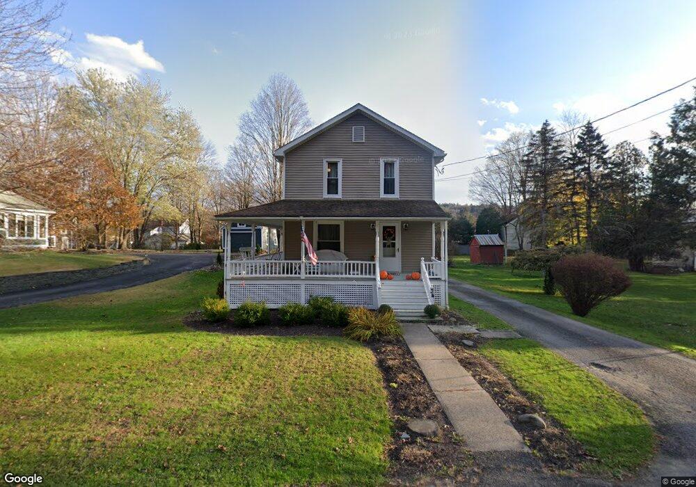
34 Oak St Nicholson, PA 18446
Estimated Value: $158,019 - $246,000
4
Beds
2
Baths
1,680
Sq Ft
$121/Sq Ft
Est. Value
About This Home
This home is located at 34 Oak St, Nicholson, PA 18446 and is currently estimated at $204,005, approximately $121 per square foot. 34 Oak St is a home located in Wyoming County with nearby schools including Lackawanna Trail Elementary Center and Lackawanna Trail Junior/Senior High School.
Ownership History
Date
Name
Owned For
Owner Type
Purchase Details
Closed on
Feb 1, 2010
Sold by
Hyndshaw Chad D and Hyndshaw Jami L
Bought by
Maurer Daniel L and Maurer Linde
Current Estimated Value
Home Financials for this Owner
Home Financials are based on the most recent Mortgage that was taken out on this home.
Original Mortgage
$137,700
Outstanding Balance
$89,000
Interest Rate
5.12%
Mortgage Type
New Conventional
Estimated Equity
$115,005
Purchase Details
Closed on
Jun 17, 2005
Sold by
Pascoe Leeann M
Bought by
Hyndshaw Chad D and Hyndshaw Jami L
Home Financials for this Owner
Home Financials are based on the most recent Mortgage that was taken out on this home.
Original Mortgage
$80,000
Interest Rate
6.2%
Mortgage Type
Adjustable Rate Mortgage/ARM
Create a Home Valuation Report for This Property
The Home Valuation Report is an in-depth analysis detailing your home's value as well as a comparison with similar homes in the area
Home Values in the Area
Average Home Value in this Area
Purchase History
We collect this data history from publicly available records. To have your information removed, we recommend requesting removal directly through your county’s website.
| Date | Buyer | Sale Price | Title Company |
|---|---|---|---|
| Maurer Daniel L | $135,000 | None Available | |
| Hyndshaw Chad D | $110,000 | None Available |
Source: Public Records
Mortgage History
We collect this data history from publicly available records. To have your information removed, we recommend requesting removal directly through your county’s website.
| Date | Status | Borrower | Loan Amount |
|---|---|---|---|
| Open | Maurer Daniel L | $137,700 | |
| Previous Owner | Hyndshaw Chad D | $80,000 |
Source: Public Records
Tax History
| Year | Tax Paid | Tax Assessment Tax Assessment Total Assessment is a certain percentage of the fair market value that is determined by local assessors to be the total taxable value of land and additions on the property. | Land | Improvement |
|---|---|---|---|---|
| 2026 | $23,867 | $17,600 | $3,000 | $14,600 |
| 2025 | $2,366 | $17,600 | $3,000 | $14,600 |
| 2024 | $2,366 | $17,600 | $3,000 | $14,600 |
| 2023 | $2,358 | $17,600 | $3,000 | $14,600 |
| 2022 | $2,367 | $17,600 | $3,000 | $14,600 |
| 2021 | $2,357 | $17,600 | $3,000 | $14,600 |
| 2020 | $2,398 | $17,600 | $3,000 | $14,600 |
| 2019 | $2,395 | $17,600 | $3,000 | $14,600 |
| 2018 | $2,330 | $17,600 | $3,000 | $14,600 |
| 2017 | $2,217 | $0 | $0 | $0 |
| 2016 | -- | $0 | $0 | $0 |
| 2015 | -- | $0 | $0 | $0 |
| 2014 | -- | $0 | $0 | $0 |
Source: Public Records
Map
Nearby Homes
- 28 Harding Ave
- 115 State St
- 5150 Station Hill Rd
- 0 Bacontown Rd
- 672 Spencer Hill Rd
- 1114 Bacontown Rd
- 13 Hillside Dr
- 31 Wright Way
- 212 Wright Way
- 0 Lewis Unit GSBSC260374
- 1114 Pennsylvania 92
- 314 Reynolds Rd
- 155 Baylor Rd
- 107 Keystone Hills Rd Unit 406
- 107 Keystone Hills Rd Unit 407
- 107 Keystone Hills Rd Unit 404
- 107 Keystone Hills Rd Unit 405
- 0 Baylors Pond Rd Unit 25-4015
- 11 Padula Rd
- 16204 Sr 407
Your Personal Tour Guide
Ask me questions while you tour the home.