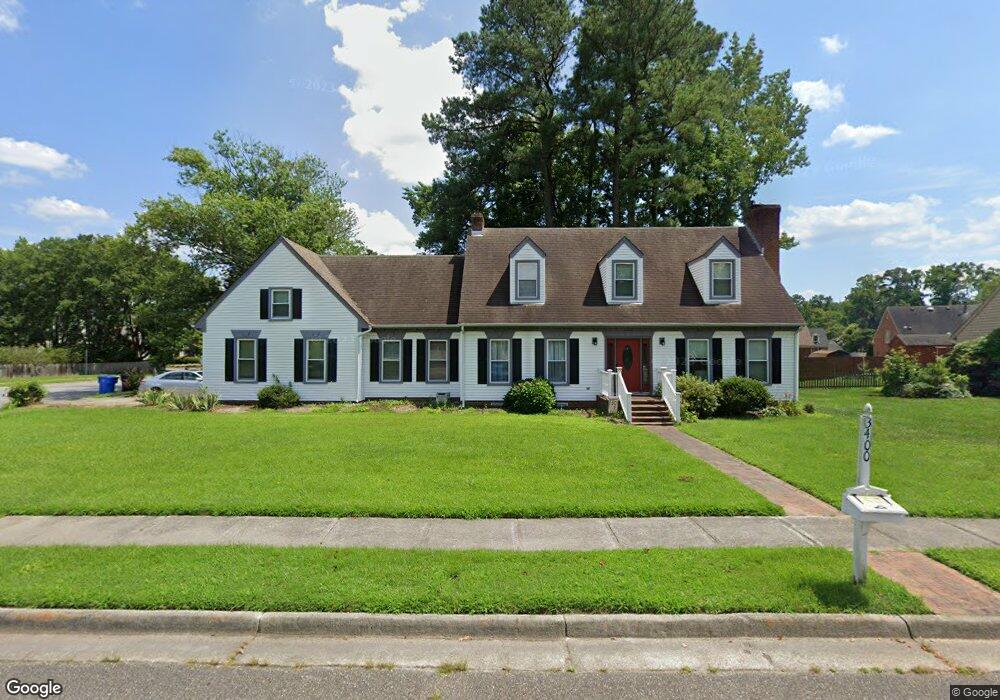
3400 Miars Farm Cir Chesapeake, VA 23321
Western Branch NeighborhoodEstimated Value: $478,173 - $505,000
4
Beds
3
Baths
2,287
Sq Ft
$215/Sq Ft
Est. Value
About This Home
This home is located at 3400 Miars Farm Cir, Chesapeake, VA 23321 and is currently estimated at $492,043, approximately $215 per square foot. 3400 Miars Farm Cir is a home located in Chesapeake City with nearby schools including Western Branch Primary School, Western Branch Intermediate School, and Western Branch Middle School.
Ownership History
Date
Name
Owned For
Owner Type
Purchase Details
Closed on
Mar 17, 2017
Sold by
Webre Earl C and Webre Suzanne M
Bought by
Gathambo Maryanne C and Mwangi Christopher G
Current Estimated Value
Home Financials for this Owner
Home Financials are based on the most recent Mortgage that was taken out on this home.
Original Mortgage
$309,294
Outstanding Balance
$254,316
Interest Rate
3.87%
Mortgage Type
FHA
Estimated Equity
$237,727
Create a Home Valuation Report for This Property
The Home Valuation Report is an in-depth analysis detailing your home's value as well as a comparison with similar homes in the area
Home Values in the Area
Average Home Value in this Area
Purchase History
| Date | Buyer | Sale Price | Title Company |
|---|---|---|---|
| Gathambo Maryanne C | $315,000 | Attorney |
Source: Public Records
Mortgage History
| Date | Status | Borrower | Loan Amount |
|---|---|---|---|
| Open | Gathambo Maryanne C | $309,294 |
Source: Public Records
Tax History Compared to Growth
Tax History
| Year | Tax Paid | Tax Assessment Tax Assessment Total Assessment is a certain percentage of the fair market value that is determined by local assessors to be the total taxable value of land and additions on the property. | Land | Improvement |
|---|---|---|---|---|
| 2025 | $4,278 | $443,700 | $150,000 | $293,700 |
| 2024 | $4,278 | $423,600 | $150,000 | $273,600 |
| 2023 | $3,665 | $384,300 | $140,000 | $244,300 |
| 2022 | $3,674 | $363,800 | $130,000 | $233,800 |
| 2021 | $3,430 | $326,700 | $105,000 | $221,700 |
| 2020 | $3,283 | $312,700 | $100,000 | $212,700 |
| 2019 | $3,219 | $306,600 | $100,000 | $206,600 |
| 2018 | $3,193 | $285,200 | $100,000 | $185,200 |
| 2017 | $3,193 | $304,100 | $100,000 | $204,100 |
| 2016 | $3,039 | $289,400 | $95,000 | $194,400 |
| 2015 | $3,039 | $289,400 | $95,000 | $194,400 |
| 2014 | $2,942 | $280,200 | $95,000 | $185,200 |
Source: Public Records
Map
Nearby Homes
- 112 Columbus Ave
- 4429 Pepper Ridge Ct
- 4310 Brighton Ln
- 3331 Golden Oaks Ln
- 4362 Oneford Place
- 3304 Michelle Ct
- 3232 Bruin Dr
- 3133 Dunworken Dr
- 3300 Laxey Ct
- 3113 Woodbaugh Dr
- 3440 Clover Rd E
- 4215 Munford Ln
- 3217 Bangor Dr
- 3549 Clover Meadows Dr
- 3454 Bruin Dr
- 3601 Radford Cir
- 2816 Ashwood Dr
- 4323 Stafford Dr
- 4601 Longleaf Place
- 4611 Longleaf Place
- 3404 Miars Farm Cir
- 3200 Peppercorn Dr
- 3401 Anita Cir
- 3208 Peppercorn Dr
- 4504 Andrea Lynne Ct
- 3405 Miars Farm Cir
- 4508 Andrea Lynne Ct
- 3209 Peppercorn Dr
- 3924 Peppercorn Way
- 3408 Miars Farm Cir
- 3922 Peppercorn Way
- 3409 Miars Farm Cir
- 3405 Anita Cir
- 3601 Margaret Ct
- 3920 Peppercorn Way
- 4512 Andrea Lynne Ct
- 3404 Anita Cir
- 3412 Miars Farm Cir
- 3407 Anita Cir
- 3213 Peppercorn Dr