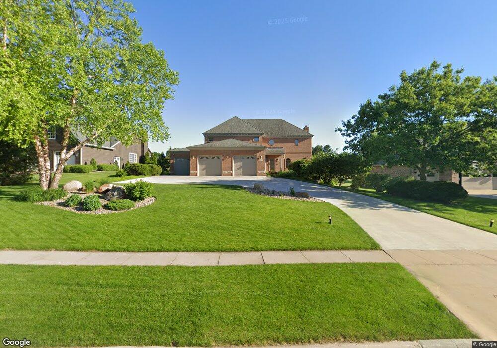
3402 Pheasant Dr Cedar Falls, IA 50613
Estimated Value: $612,000 - $709,000
3
Beds
4
Baths
3,552
Sq Ft
$191/Sq Ft
Est. Value
About This Home
This home is located at 3402 Pheasant Dr, Cedar Falls, IA 50613 and is currently estimated at $678,205, approximately $190 per square foot. 3402 Pheasant Dr is a home located in Black Hawk County with nearby schools including Helen A. Hansen Elementary School, Holmes Junior High School, and Cedar Falls High School.
Ownership History
Date
Name
Owned For
Owner Type
Purchase Details
Closed on
Oct 3, 2012
Sold by
Voorhees Peter E and Voorhees Marilyn S
Bought by
Voorhees Marlyn S and Marilyn S Voorhees Revocable Trust
Current Estimated Value
Purchase Details
Closed on
Jun 2, 2006
Sold by
Pheasant Hollow Inc
Bought by
Dizdarevic Bajro and Dizdarevic Rubija
Create a Home Valuation Report for This Property
The Home Valuation Report is an in-depth analysis detailing your home's value as well as a comparison with similar homes in the area
Home Values in the Area
Average Home Value in this Area
Purchase History
| Date | Buyer | Sale Price | Title Company |
|---|---|---|---|
| Voorhees Marlyn S | -- | None Available | |
| Dizdarevic Bajro | $50,000 | None Available |
Source: Public Records
Tax History Compared to Growth
Tax History
| Year | Tax Paid | Tax Assessment Tax Assessment Total Assessment is a certain percentage of the fair market value that is determined by local assessors to be the total taxable value of land and additions on the property. | Land | Improvement |
|---|---|---|---|---|
| 2025 | $9,626 | $752,780 | $75,600 | $677,180 |
| 2024 | $9,626 | $622,130 | $75,600 | $546,530 |
| 2023 | $10,968 | $622,130 | $75,600 | $546,530 |
| 2022 | $11,098 | $602,990 | $75,600 | $527,390 |
| 2021 | $11,016 | $602,990 | $75,600 | $527,390 |
| 2020 | $10,826 | $601,990 | $72,800 | $529,190 |
| 2019 | $10,826 | $601,990 | $72,800 | $529,190 |
| 2018 | $10,964 | $601,990 | $72,800 | $529,190 |
| 2017 | $11,130 | $601,990 | $72,800 | $529,190 |
| 2016 | $10,414 | $598,070 | $72,800 | $525,270 |
| 2015 | $10,414 | $598,070 | $72,800 | $525,270 |
| 2014 | $10,064 | $571,800 | $72,800 | $499,000 |
Source: Public Records
Map
Nearby Homes
- 3413 Pheasant Dr
- 3702 Apollo St
- 3603 Apollo St
- 2907 W 3rd St
- 2906 W 3rd St
- 223 Winding Ridge Rd
- 4124 Thresher Ct Unit 306
- 4032 Wynnewood Dr
- 4128 Shocker Rd
- 4416 Wynnewood Dr
- 4209 Thresher Ct
- Lots 1-2 Nordic Dr
- Lots 3-4 Nordic Dr
- Lots 5-6 Nordic Dr
- 4123 Berry Hill Rd
- 0 W Glen Development Land
- 4305 Autumn Ridge Rd Unit 209
- 4305 Autumn Ridge Rd Unit 216
- 4305 Autumn Ridge Rd Unit 214
- 4306 Berry Hill Rd
- 3324 Pheasant Dr
- 3412 Pheasant Dr
- 3422 Pheasant Dr
- 3308 Pheasant Dr
- 3403 Pheasant Dr
- 3500 Pheasant Dr
- 3317 Pheasant Dr
- 3423 Pheasant Dr
- 3307 Pheasant Dr
- Lot 5 Shelley Ct
- Lot 4 Shelley Ct
- Lot 9 Shelley Ct
- Lot 8 Shelley Ct
- Lot 7 Shelley Ct
- Lot 6 Shelley Ct
- Lot 10 Shelley Ct
- 127 Kaspend Place
- 117 Kaspend Place
- 3904 Pheasant Dr
- Lot 8 Pheasant Dr