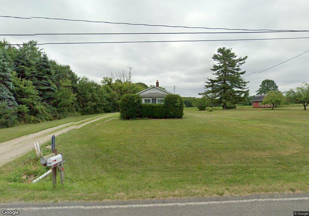
3408 Sanford Rd Rootstown, OH 44272
Estimated Value: $178,096 - $331,000
2
Beds
1
Bath
750
Sq Ft
$332/Sq Ft
Est. Value
About This Home
This home is located at 3408 Sanford Rd, Rootstown, OH 44272 and is currently estimated at $249,274, approximately $332 per square foot. 3408 Sanford Rd is a home located in Portage County with nearby schools including Rootstown Middle School - Schnee Building and Rootstown High School.
Ownership History
Date
Name
Owned For
Owner Type
Purchase Details
Closed on
Oct 24, 2023
Sold by
Siegenthaler Eileen Mary
Bought by
Siegenthaler Stephen J
Current Estimated Value
Purchase Details
Closed on
Sep 30, 2008
Sold by
Sanor Virginia O
Bought by
Seigenthaler Eileen Mary
Purchase Details
Closed on
May 21, 2007
Sold by
Sanor Donald L and Sanor Virginia O
Bought by
Sanor Donald L and Sanor Virginia O
Purchase Details
Closed on
Jan 1, 1990
Bought by
Sanor Donald L
Create a Home Valuation Report for This Property
The Home Valuation Report is an in-depth analysis detailing your home's value as well as a comparison with similar homes in the area
Home Values in the Area
Average Home Value in this Area
Purchase History
| Date | Buyer | Sale Price | Title Company |
|---|---|---|---|
| Siegenthaler Stephen J | -- | None Listed On Document | |
| Seigenthaler Eileen Mary | $73,000 | Portage Title Agency | |
| Sanor Donald L | -- | Attorney | |
| Sanor Donald L | -- | -- |
Source: Public Records
Tax History Compared to Growth
Tax History
| Year | Tax Paid | Tax Assessment Tax Assessment Total Assessment is a certain percentage of the fair market value that is determined by local assessors to be the total taxable value of land and additions on the property. | Land | Improvement |
|---|---|---|---|---|
| 2024 | $2,025 | $48,690 | $13,970 | $34,720 |
| 2023 | $1,755 | $37,520 | $12,320 | $25,200 |
| 2022 | $1,729 | $37,520 | $12,320 | $25,200 |
| 2021 | $1,723 | $37,520 | $12,320 | $25,200 |
| 2020 | $1,579 | $33,080 | $11,730 | $21,350 |
| 2019 | $1,585 | $33,080 | $11,730 | $21,350 |
| 2018 | $1,084 | $21,140 | $12,460 | $8,680 |
| 2017 | $1,084 | $21,140 | $12,460 | $8,680 |
| 2016 | $1,050 | $21,140 | $12,460 | $8,680 |
| 2015 | $1,062 | $21,140 | $12,460 | $8,680 |
| 2014 | $1,081 | $21,140 | $12,460 | $8,680 |
| 2013 | $1,074 | $21,140 | $12,460 | $8,680 |
Source: Public Records
Map
Nearby Homes
- 3987 J A Vaughn Ave
- 5560 Wilkes Rd
- 2547 Industry Rd
- 4958 Bassett Rd
- 0 New Milford Rd Unit 11489599
- 0 New Milford Rd Unit 5108183
- 2322 New Milford Rd
- 2113 New Milford Rd
- 0 Lynn Rd Unit 5110102
- 0 St Andrews Way Unit 5094250
- 3021 Hartville Rd
- 4691 Scenic Dr
- 0 Rootstown Rd Unit 5173350
- V/L St Andrews Way
- 3637 Old Forge Rd
- 4770 Valley Hills Dr
- 6747 Giddings Rd
- V/L 2 Lynn Rd
- V/L Lynn Rd
- 3798 State Route 183
- 3395 Sanford Rd
- 3421 Sanford Rd
- 3389 Sanford Rd
- 3369 Sanford Rd
- 3348 Sanford Rd
- 3337 Sanford Rd
- 3477 Sanford Rd
- 3490 Sanford Rd
- 3325 Sanford Rd
- 3514 Sanford Rd
- 3308 Sanford Rd
- 3501 Sanford Rd
- 3526 Sanford Rd
- 3535 Sanford Rd
- 3553 Sanford Rd
- 3274 Cook Rd
- 3218 Cook Rd
- 3278 Cook Rd
- 3273 Cook Rd
- 3237 Cook Rd