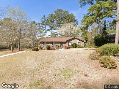
341 Brookridge Dr Lagrange, GA 30241
Estimated Value: $197,606 - $227,000
3
Beds
2
Baths
1,640
Sq Ft
$132/Sq Ft
Est. Value
About This Home
This home is located at 341 Brookridge Dr, Lagrange, GA 30241 and is currently estimated at $215,902, approximately $131 per square foot. 341 Brookridge Dr is a home located in Troup County with nearby schools including Franklin Forest Elementary School, Hollis Hand Elementary School, and Ethel W. Kight Elementary School.
Ownership History
Date
Name
Owned For
Owner Type
Purchase Details
Closed on
Jan 10, 1991
Sold by
Billy Ray Brazeal
Bought by
Richter H Pope
Current Estimated Value
Purchase Details
Closed on
Mar 1, 1986
Sold by
Faye Billy and Faye Brazeal
Bought by
Billy Ray Brazeal
Purchase Details
Closed on
Feb 1, 1986
Sold by
Tony Shumake
Bought by
Faye Billy and Faye Brazeal
Purchase Details
Closed on
Nov 1, 1970
Sold by
Lagrange Investment Co
Bought by
Tony Shumake
Purchase Details
Closed on
Sep 1, 1968
Sold by
Roy M Waller
Bought by
Lagrange Investment Co
Create a Home Valuation Report for This Property
The Home Valuation Report is an in-depth analysis detailing your home's value as well as a comparison with similar homes in the area
Home Values in the Area
Average Home Value in this Area
Purchase History
| Date | Buyer | Sale Price | Title Company |
|---|---|---|---|
| Richter H Pope | $80,500 | -- | |
| Billy Ray Brazeal | -- | -- | |
| Faye Billy | -- | -- | |
| Tony Shumake | -- | -- | |
| Lagrange Investment Co | -- | -- |
Source: Public Records
Tax History Compared to Growth
Tax History
| Year | Tax Paid | Tax Assessment Tax Assessment Total Assessment is a certain percentage of the fair market value that is determined by local assessors to be the total taxable value of land and additions on the property. | Land | Improvement |
|---|---|---|---|---|
| 2024 | $1,664 | $63,020 | $10,000 | $53,020 |
| 2023 | $1,021 | $57,340 | $10,000 | $47,340 |
| 2022 | $1,457 | $54,180 | $10,000 | $44,180 |
| 2021 | $1,215 | $42,276 | $8,000 | $34,276 |
| 2020 | $1,215 | $42,276 | $8,000 | $34,276 |
| 2019 | $1,082 | $37,848 | $8,000 | $29,848 |
| 2018 | $979 | $34,440 | $6,000 | $28,440 |
| 2017 | $979 | $34,440 | $6,000 | $28,440 |
| 2016 | $949 | $33,436 | $6,000 | $27,436 |
| 2015 | $899 | $31,718 | $6,000 | $25,718 |
| 2014 | $859 | $30,365 | $6,000 | $24,365 |
| 2013 | -- | $32,032 | $6,000 | $26,032 |
Source: Public Records
Map
Nearby Homes
- 347 Brookridge Dr
- 211 Rutland Cir
- 600 S Harlem Cir
- 208 Park Hill Dr
- 218 Hearthstone Dr
- 806 New Franklin Rd
- 900 North St
- 209 Lenox Cir
- 205 Lenox Cir
- 207 Lenox Cir
- 109 Horace King St
- 5 Curran Ave
- 902 Georgia Ave
- 21 Barnard Ave
- 45 N Cary St
- 914 Greenville St
- 1206 Pool Mill St
- 405 Sanford Ave
- 405 N Sanford Ave
- 424 Sweetwood Ct
- 341 Brookridge Dr
- 343 Brookridge Dr
- 345 Brookridge Dr
- 344 Brookridge Dr
- 469 Camelot Ct
- 353 Hickory Terrace
- 342 Brookridge Dr
- 340 Brookridge Dr
- 357 Brookridge Dr
- 361 Hickory Terrace
- 0 Brookridge Dr
- 0 Brookridge Dr Unit 7052986
- 0 Brookridge Dr Unit 8344134
- 0 Brookridge Dr Unit 8180382
- 0 Brookridge Dr Unit 8133527
- 0 Brookridge Dr Unit 7606130
- 0 Brookridge Dr Unit 8088665
- 0 Brookridge Dr Unit 3058323
- 0 Brookridge Dr Unit 3058321
- 0 Brookridge Dr Unit LOT 12 9007332