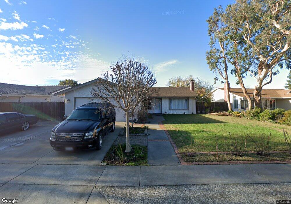
34101 Sylvester Dr Fremont, CA 94555
Northgate-Union City NeighborhoodEstimated Value: $1,731,710 - $1,937,000
4
Beds
2
Baths
1,474
Sq Ft
$1,236/Sq Ft
Est. Value
About This Home
This home is located at 34101 Sylvester Dr, Fremont, CA 94555 and is currently estimated at $1,821,178, approximately $1,235 per square foot. 34101 Sylvester Dr is a home located in Alameda County with nearby schools including Warwick Elementary School, Thornton Middle School, and American High School.
Ownership History
Date
Name
Owned For
Owner Type
Purchase Details
Closed on
Feb 3, 2004
Sold by
Ashcraft David C and Ashcraft June A
Bought by
Aguirre Efrain and Aguirre Graciela
Current Estimated Value
Home Financials for this Owner
Home Financials are based on the most recent Mortgage that was taken out on this home.
Original Mortgage
$323,000
Outstanding Balance
$151,696
Interest Rate
5.85%
Mortgage Type
Purchase Money Mortgage
Estimated Equity
$1,669,482
Create a Home Valuation Report for This Property
The Home Valuation Report is an in-depth analysis detailing your home's value as well as a comparison with similar homes in the area
Home Values in the Area
Average Home Value in this Area
Purchase History
| Date | Buyer | Sale Price | Title Company |
|---|---|---|---|
| Aguirre Efrain | $515,000 | Ticor Title Company Of Ca |
Source: Public Records
Mortgage History
| Date | Status | Borrower | Loan Amount |
|---|---|---|---|
| Open | Aguirre Efrain | $323,000 | |
| Closed | Aguirre Efrain | $89,000 |
Source: Public Records
Tax History Compared to Growth
Tax History
| Year | Tax Paid | Tax Assessment Tax Assessment Total Assessment is a certain percentage of the fair market value that is determined by local assessors to be the total taxable value of land and additions on the property. | Land | Improvement |
|---|---|---|---|---|
| 2025 | $8,953 | $732,180 | $219,654 | $512,526 |
| 2024 | $8,953 | $717,827 | $215,348 | $502,479 |
| 2023 | $8,711 | $703,751 | $211,125 | $492,626 |
| 2022 | $8,595 | $689,955 | $206,986 | $482,969 |
| 2021 | $8,386 | $676,431 | $202,929 | $473,502 |
| 2020 | $8,396 | $669,500 | $200,850 | $468,650 |
| 2019 | $8,302 | $656,371 | $196,911 | $459,460 |
| 2018 | $8,140 | $643,501 | $193,050 | $450,451 |
| 2017 | $7,937 | $630,884 | $189,265 | $441,619 |
| 2016 | $7,801 | $618,514 | $185,554 | $432,960 |
| 2015 | $7,696 | $609,224 | $182,767 | $426,457 |
| 2014 | $6,818 | $534,000 | $160,200 | $373,800 |
Source: Public Records
Map
Nearby Homes
- 34179 Bowling Green Common
- 3355 Winter Wren Place
- 3851 Milton Terrace
- 3840 Springfield Common
- 3691 Thrush Terrace
- 3216 Sanderling Dr
- 33499 Quail Run Rd
- 34552 Nantucket Common
- 34539 Nantucket Common
- 4015 Clydesdale Common
- 34512 Nantucket Common
- 2717 Meadowlark Dr
- 4243 Nerissa Cir
- 30 Palm Dr Unit 30
- 4480 Norocco Cir
- 34579 Bluestone Common
- 34926 Moina Shaiq Common
- 33283 Sunriver Common
- 192 Hawaii Cir
- 33228 Jamie Cir
- 34119 Sylvester Dr
- 34079 Sylvester Dr
- 34082 Cavendish Place
- 34096 Cavendish Place
- 34137 Sylvester Dr
- 34061 Sylvester Dr
- 34068 Cavendish Place
- 3340 Hogarth Place
- 34110 Cavendish Place
- 3339 Trafalgar Rd
- 34041 Sylvester Dr
- 34054 Cavendish Place
- 3332 Hogarth Place
- 3341 Hogarth Place
- 34124 Cavendish Place
- 3327 Trafalgar Rd
- 3340 Trafalgar Rd
- 34185 Sylvester Dr
- 34017 Sylvester Dr
- 3333 Hogarth Place