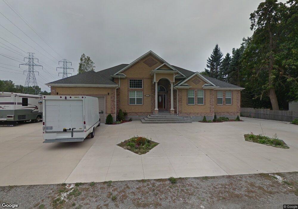
3419 S Kearsley Blvd Flint, MI 48506
Northeast Flint NeighborhoodEstimated Value: $124,000 - $558,360
3
Beds
1
Bath
1,075
Sq Ft
$297/Sq Ft
Est. Value
About This Home
This home is located at 3419 S Kearsley Blvd, Flint, MI 48506 and is currently estimated at $319,120, approximately $296 per square foot. 3419 S Kearsley Blvd is a home located in Genesee County with nearby schools including Weston Elementary School, Kate Dowdall Elementary School, and Leota Fiedler Elementary School.
Ownership History
Date
Name
Owned For
Owner Type
Purchase Details
Closed on
Jul 22, 2019
Sold by
Khuit Aleksandr and Khuit Svidtalana
Bought by
Khuit Aleksandr and Khuit Sviutlana
Current Estimated Value
Purchase Details
Closed on
Mar 13, 2014
Sold by
Khait Arkadiy G and Khait Leokadiya A
Bought by
Khait Aleksandr A and Khait Sviatlana
Purchase Details
Closed on
Feb 3, 2010
Sold by
Paxton Roderic C and Paxton Sheila K
Bought by
Federal Home Loan Mortgage Corp
Create a Home Valuation Report for This Property
The Home Valuation Report is an in-depth analysis detailing your home's value as well as a comparison with similar homes in the area
Home Values in the Area
Average Home Value in this Area
Purchase History
| Date | Buyer | Sale Price | Title Company |
|---|---|---|---|
| Khuit Aleksandr | -- | None Available | |
| Khait Aleksandr A | -- | None Available | |
| Federal Home Loan Mortgage Corp | $81,757 | None Available |
Source: Public Records
Tax History Compared to Growth
Tax History
| Year | Tax Paid | Tax Assessment Tax Assessment Total Assessment is a certain percentage of the fair market value that is determined by local assessors to be the total taxable value of land and additions on the property. | Land | Improvement |
|---|---|---|---|---|
| 2025 | $6,374 | $300,800 | $0 | $0 |
| 2024 | $1,851 | $298,500 | $0 | $0 |
| 2023 | $1,766 | $265,100 | $0 | $0 |
| 2022 | $5,276 | $208,200 | $0 | $0 |
| 2021 | $5,227 | $183,100 | $0 | $0 |
| 2020 | $1,615 | $164,500 | $0 | $0 |
| 2019 | $1,589 | $148,200 | $0 | $0 |
| 2018 | $7,378 | $136,600 | $0 | $0 |
| 2017 | $4,374 | $83,800 | $0 | $0 |
| 2016 | $4,337 | $83,300 | $0 | $0 |
| 2015 | $4,042 | $83,400 | $0 | $0 |
| 2014 | $628 | $57,500 | $0 | $0 |
| 2012 | -- | $26,300 | $26,300 | $0 |
Source: Public Records
Map
Nearby Homes
- 4055 Mitchell Dr
- 3301 S Kearsley Blvd
- 3456 E Pierson Rd
- 3364 E Pierson Rd
- 3088 Layman Dr
- 3299 E Pierson Rd
- 4237 Sugar Maple Run Unit 8
- 4231 Sugar Maple Run Unit 7
- 4225 Sugar Maple Run Unit 6
- 4213 Sugar Maple Run Unit 4
- 4207 Sugar Maple Run Unit 3
- 3200 N Averill Ave
- 4101 Sugar Maple Run Unit 1
- 4413 Maple Leaf Trail
- 4419 Maple Leaf Trail
- 4408 Maple Leaf Trail
- 3413 Blue Lake Dr
- 00 Richfield Rd
- 4414 Maple Leaf Trail
- 4141 Hidden View Dr
- 3419 S Kearsley Blvd
- 3376 N Center Rd
- 3350 N Center Rd
- 3414 S Kearsley Blvd
- 3414 S Kearsley Blvd
- 3344 N Center Rd
- 3385 S Kearsley Blvd
- 3384 S Kearsley Blvd
- 4015 Mitchell Dr
- 4096 Mitchell Dr
- 3375 N Center Rd
- 4031 Mitchell Dr
- 4039 Mitchell Dr
- 3399 N Center Rd
- 4090 Mitchell Dr
- 3365 S Kearsley Blvd
- 4078 Mitchell Dr
- 4047 Mitchell Dr
- 3517 S Kearsley Blvd
- 3517 S Kearsley Blvd