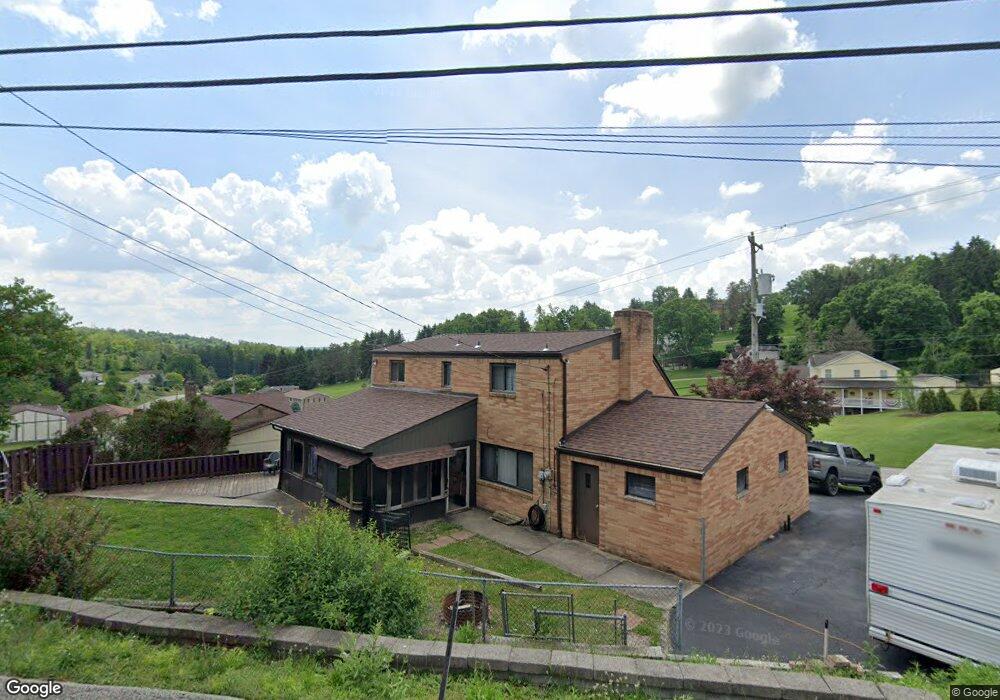
342 Ewing Rd Carnegie, PA 15106
Estimated Value: $210,000 - $289,000
3
Beds
2
Baths
1,350
Sq Ft
$186/Sq Ft
Est. Value
About This Home
This home is located at 342 Ewing Rd, Carnegie, PA 15106 and is currently estimated at $250,928, approximately $185 per square foot. 342 Ewing Rd is a home located in Allegheny County with nearby schools including Chartiers Valley Intermediate School, Chartiers Valley Primary School, and Chartiers Valley Middle School.
Ownership History
Date
Name
Owned For
Owner Type
Purchase Details
Closed on
Oct 16, 2024
Sold by
Gazda John Est and Gazda Rebecca
Bought by
Blackburn Ronald 3Rd and Blackburn
Current Estimated Value
Home Financials for this Owner
Home Financials are based on the most recent Mortgage that was taken out on this home.
Original Mortgage
$100,000
Outstanding Balance
$98,949
Interest Rate
6.35%
Mortgage Type
New Conventional
Estimated Equity
$151,979
Purchase Details
Closed on
Oct 15, 2024
Sold by
Gazda Rebecca and Gazda John
Bought by
Blackburn Ronald and Blackburn Sasha
Home Financials for this Owner
Home Financials are based on the most recent Mortgage that was taken out on this home.
Original Mortgage
$100,000
Outstanding Balance
$98,949
Interest Rate
6.35%
Mortgage Type
New Conventional
Estimated Equity
$151,979
Purchase Details
Closed on
Apr 22, 1994
Sold by
Perpetua Rayna A
Bought by
Gazda John and Gazda Rebecca
Create a Home Valuation Report for This Property
The Home Valuation Report is an in-depth analysis detailing your home's value as well as a comparison with similar homes in the area
Home Values in the Area
Average Home Value in this Area
Purchase History
| Date | Buyer | Sale Price | Title Company |
|---|---|---|---|
| Blackburn Ronald 3Rd | $198,000 | -- | |
| Blackburn Ronald | $198,000 | -- | |
| Blackburn Ronald | $198,000 | -- | |
| Gazda John | -- | -- |
Source: Public Records
Mortgage History
| Date | Status | Borrower | Loan Amount |
|---|---|---|---|
| Open | Blackburn Ronald | $100,000 | |
| Closed | Blackburn Ronald | $100,000 |
Source: Public Records
Tax History
| Year | Tax Paid | Tax Assessment Tax Assessment Total Assessment is a certain percentage of the fair market value that is determined by local assessors to be the total taxable value of land and additions on the property. | Land | Improvement |
|---|---|---|---|---|
| 2025 | $3,088 | $124,400 | $40,600 | $83,800 |
| 2024 | $3,088 | $106,400 | $40,600 | $65,800 |
| 2023 | $3,003 | $106,400 | $40,600 | $65,800 |
| 2022 | $2,935 | $106,400 | $40,600 | $65,800 |
| 2021 | $2,877 | $106,400 | $40,600 | $65,800 |
| 2020 | $2,808 | $106,400 | $40,600 | $65,800 |
| 2019 | $2,756 | $106,400 | $40,600 | $65,800 |
| 2018 | $352 | $106,400 | $40,600 | $65,800 |
| 2017 | $2,603 | $106,400 | $40,600 | $65,800 |
| 2016 | $503 | $106,400 | $40,600 | $65,800 |
| 2015 | $503 | $106,400 | $40,600 | $65,800 |
| 2014 | $2,520 | $106,400 | $40,600 | $65,800 |
Source: Public Records
Map
Nearby Homes
- 134 Baldwin Rd
- 141 Centennial Dr
- 728 Freedom Dr
- 176 Mcmichael Rd
- 762 Olivia St
- 760 Olivia St
- 766 Olivia St
- 761 Olivia St
- 765 Olivia St
- 767 Olivia St
- 51 Mcmichael Rd
- 225 Sunrise Dr
- Lot 53 Nottingham Dr
- 1446 Iroquois Dr
- 1062 Colony Dr
- 1234 Pennsbury Blvd Unit 359
- 303 Pennsview Ct Unit 98
- 117 Community Ct Unit 57
- 779 Darlington St
- 2212 Kenzie Dr Unit M12
Your Personal Tour Guide
Ask me questions while you tour the home.