Estimated Value: $166,000 - $372,000
1
Bed
1
Bath
780
Sq Ft
$314/Sq Ft
Est. Value
About This Home
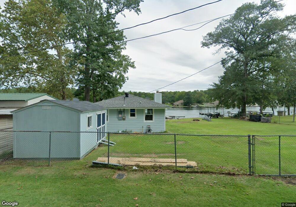
This home is located at 342 Muskogee Rd, Royal, AR 71968 and is currently estimated at $245,089, approximately $314 per square foot. 342 Muskogee Rd is a home located in Garland County with nearby schools including Lake Hamilton Primary School, Lake Hamilton Interm. School, and Lake Hamilton Elementary School.
Ownership History
Date
Name
Owned For
Owner Type
Purchase Details
Closed on
Mar 2, 2005
Sold by
Tucker Larry D and Tucker Debbie J
Bought by
Gray Leonard and Gray Shana
Current Estimated Value
Purchase Details
Closed on
Sep 28, 2001
Sold by
Not Provided
Bought by
Tucker Larry D and Tucker Debbie J
Purchase Details
Closed on
Aug 31, 2001
Sold by
Not Provided
Bought by
Pitts Frank and Pitts Brenda
Purchase Details
Closed on
Oct 10, 1991
Sold by
Not Provided
Bought by
Pitts Frank and Pitts Brenda
Purchase Details
Closed on
Jan 1, 1901
Bought by
Lott Arnold G and 142 Oak Grove Rd.
Create a Home Valuation Report for This Property
The Home Valuation Report is an in-depth analysis detailing your home's value as well as a comparison with similar homes in the area
Home Values in the Area
Average Home Value in this Area
Purchase History
| Date | Buyer | Sale Price | Title Company |
|---|---|---|---|
| Gray Leonard | $83,000 | Hot Spring Title Company Inc | |
| Tucker Larry D | $50,000 | -- | |
| Pitts Frank | $36,000 | -- | |
| Pitts Frank | -- | -- | |
| Lott Arnold G | -- | -- |
Source: Public Records
Tax History
| Year | Tax Paid | Tax Assessment Tax Assessment Total Assessment is a certain percentage of the fair market value that is determined by local assessors to be the total taxable value of land and additions on the property. | Land | Improvement |
|---|---|---|---|---|
| 2025 | $1,769 | $39,850 | $21,630 | $18,220 |
| 2024 | $1,693 | $39,850 | $21,630 | $18,220 |
| 2023 | $1,563 | $39,850 | $21,630 | $18,220 |
| 2022 | $1,502 | $39,850 | $21,630 | $18,220 |
| 2021 | $1,384 | $29,730 | $18,540 | $11,190 |
| 2020 | $1,384 | $29,730 | $18,540 | $11,190 |
| 2019 | $1,314 | $29,730 | $18,540 | $11,190 |
| 2018 | $1,314 | $29,730 | $18,540 | $11,190 |
| 2017 | $1,314 | $29,730 | $18,540 | $11,190 |
| 2016 | $837 | $14,210 | $9,360 | $4,850 |
| 2015 | $628 | $14,210 | $9,360 | $4,850 |
| 2014 | $628 | $14,210 | $9,360 | $4,850 |
Source: Public Records
Map
Nearby Homes
- 152 Muskogee Rd
- 0 River Mill Ct Unit 25041085
- 118 Muskogee Rd
- 0 Algonkin Dr Unit 1319545
- Lots 35 & 36 Maricopa Dr
- 101 & 111 Muskogee
- 173 Barbary Rd Unit ID 110207
- 108 W Miracle Place
- 363 Old Bear Rd
- 469 Treasure Isle Rd
- Block 2 Lot 77 Diamond Dr
- 161 Ben St
- 205 Buccaneer St
- 732 Old Bear Rd
- 104 Diamond Dr
- XXX Pirate Dr
- 1516 Treasure Isle Rd
- 337 Gold Nugget Loop
- 112 Quaker Ln
- Lot 5&6/Blk 3 Williams Rd
- 332 Muskogee Rd Unit 340 Muskogee
- 332 Muskogee Rd
- 313 Muskogee Rd
- 353 Muskogee Rd
- 356 Muskogee Rd
- 314 Muskogee Rd
- 357 Muskogee Rd
- 308 Muskogee Rd
- 309 Muskogee Rd
- 118 Colonel Wilson Trail
- 252 Muskogee Rd
- 120 Colonel Wilson Trail
- 246 Muskogee Rd
- 289 River Mill Point
- 240 Muskogee Rd
- 277 River Mill Point
- 291 River Mill Point
- 293 River Mill Point
- 265 River Mill Point
- TBD Colonel Wilson Trail
Your Personal Tour Guide
Ask me questions while you tour the home.