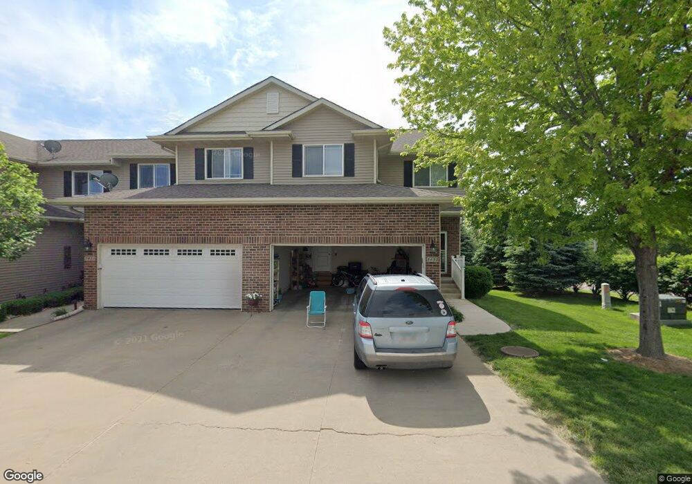
3432 84th St Unit 1 Urbandale, IA 50322
Estimated Value: $233,000 - $261,000
3
Beds
4
Baths
1,457
Sq Ft
$171/Sq Ft
Est. Value
About This Home
This home is located at 3432 84th St Unit 1, Urbandale, IA 50322 and is currently estimated at $248,495, approximately $170 per square foot. 3432 84th St Unit 1 is a home located in Polk County with nearby schools including Valerius Elementary School, Karen Acres Elementary School, and Urbandale Middle School.
Ownership History
Date
Name
Owned For
Owner Type
Purchase Details
Closed on
Sep 11, 2008
Sold by
Lowry & Hodge Llc
Bought by
Koontz Kathy D
Current Estimated Value
Home Financials for this Owner
Home Financials are based on the most recent Mortgage that was taken out on this home.
Original Mortgage
$166,650
Outstanding Balance
$106,878
Interest Rate
5.87%
Mortgage Type
Purchase Money Mortgage
Estimated Equity
$141,617
Create a Home Valuation Report for This Property
The Home Valuation Report is an in-depth analysis detailing your home's value as well as a comparison with similar homes in the area
Home Values in the Area
Average Home Value in this Area
Purchase History
| Date | Buyer | Sale Price | Title Company |
|---|---|---|---|
| Koontz Kathy D | $175,000 | Itc |
Source: Public Records
Mortgage History
| Date | Status | Borrower | Loan Amount |
|---|---|---|---|
| Open | Koontz Kathy D | $166,650 |
Source: Public Records
Tax History Compared to Growth
Tax History
| Year | Tax Paid | Tax Assessment Tax Assessment Total Assessment is a certain percentage of the fair market value that is determined by local assessors to be the total taxable value of land and additions on the property. | Land | Improvement |
|---|---|---|---|---|
| 2025 | $3,822 | $252,100 | $28,900 | $223,200 |
| 2024 | $3,822 | $221,500 | $25,000 | $196,500 |
| 2023 | $3,758 | $221,500 | $25,000 | $196,500 |
| 2022 | $3,712 | $184,000 | $21,400 | $162,600 |
| 2021 | $3,818 | $184,000 | $21,400 | $162,600 |
| 2020 | $3,750 | $179,500 | $22,200 | $157,300 |
| 2019 | $3,550 | $179,500 | $22,200 | $157,300 |
| 2018 | $3,416 | $162,900 | $21,400 | $141,500 |
| 2017 | $3,302 | $162,900 | $21,400 | $141,500 |
| 2016 | $3,216 | $155,000 | $21,900 | $133,100 |
| 2015 | $3,216 | $155,000 | $21,900 | $133,100 |
| 2014 | $3,314 | $164,300 | $25,900 | $138,400 |
Source: Public Records
Map
Nearby Homes
- 8178 Dellwood Dr Unit 8178
- 8047 Dellwood Dr
- 3400 78th St
- 37 89th St
- 3900 Rolling Green Dr
- 8505 Madison Ave
- 4517 90th St
- 4505 90th St
- 4500 90th St
- 7815 Douglas Ave Unit 304
- 7815 Douglas Ave Unit 107
- 2651 82nd St
- 3221 Ashwood Dr
- 8001 Sheridan Dr
- 8501 Airline Ave
- 3924 80th St
- 3805 92nd Dr
- 8115 Cobblestone Ct
- 2548 Pine Cir
- 7422 Oak Brook Dr
- 3422 84th St Unit 6
- 3426 84th St Unit 4
- 3428 84th St Unit 3
- 3430 84th St Unit 2
- 3430 84th St
- 8309 Wilden Dr
- 8310 Wilden Dr
- 8308 Wilden Dr
- 8307 Wilden Dr
- 8306 Wilden Dr
- 8305 Wilden Dr
- 3404 84th St Unit 13
- 3408 84th St Unit 12
- 3410 84th St Unit 11
- 3412 84th St Unit 10
- 3416 84th St Unit 8
- 3418 84th St Unit 7
- 8304 Wilden Dr
- 8303 Wilden Dr
- 8302 Wilden Dr