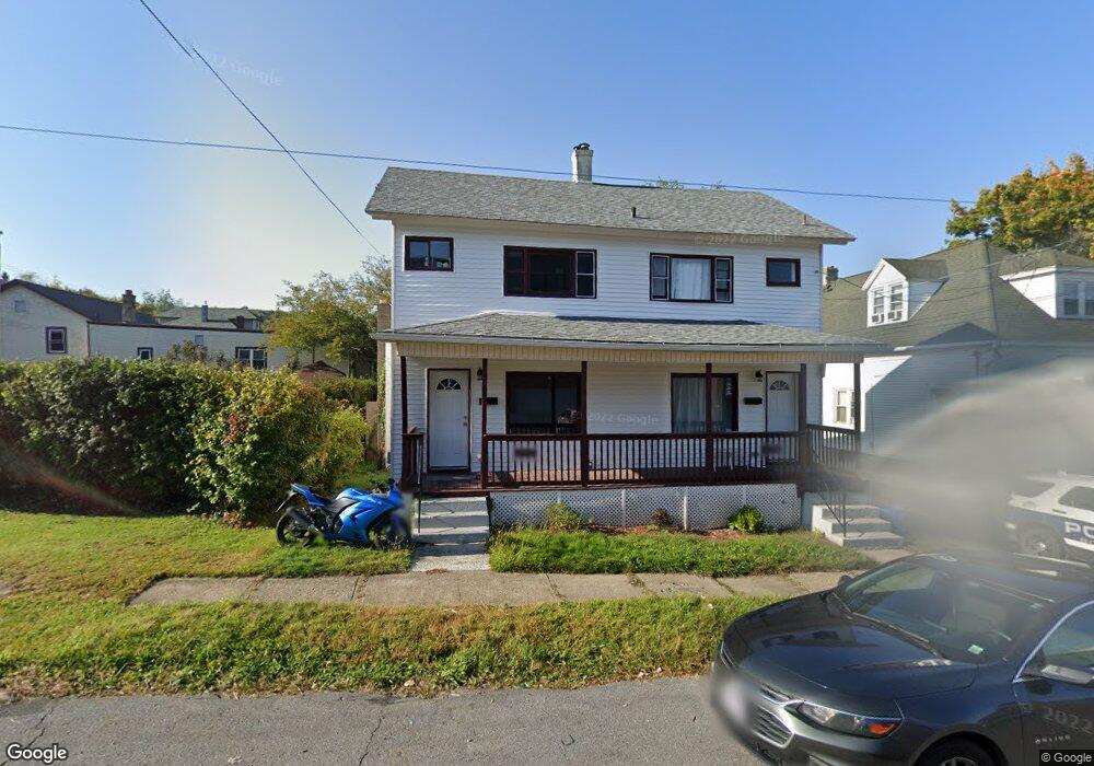
344 Pear St Unit 346 Scranton, PA 18505
South Side NeighborhoodEstimated Value: $136,000 - $200,000
3
Beds
2
Baths
900
Sq Ft
$191/Sq Ft
Est. Value
About This Home
This home is located at 344 Pear St Unit 346, Scranton, PA 18505 and is currently estimated at $171,667, approximately $190 per square foot. 344 Pear St Unit 346 is a home located in Lackawanna County with nearby schools including Ratcliffe Elementary School, Jackson Davis Elementary School, and Adams Elementary School.
Ownership History
Date
Name
Owned For
Owner Type
Purchase Details
Closed on
Aug 21, 2021
Sold by
Guarino Joseph and Guarino Melissa
Bought by
Gm 1 Investments Llc
Current Estimated Value
Home Financials for this Owner
Home Financials are based on the most recent Mortgage that was taken out on this home.
Original Mortgage
$102,200
Interest Rate
2.8%
Mortgage Type
Construction
Purchase Details
Closed on
Jul 26, 2004
Bought by
Guarino Joseph and Guarino Melissa
Create a Home Valuation Report for This Property
The Home Valuation Report is an in-depth analysis detailing your home's value as well as a comparison with similar homes in the area
Home Values in the Area
Average Home Value in this Area
Purchase History
| Date | Buyer | Sale Price | Title Company |
|---|---|---|---|
| Gm 1 Investments Llc | $55,000 | None Available | |
| Guarino Joseph | $79,500 | -- |
Source: Public Records
Mortgage History
| Date | Status | Borrower | Loan Amount |
|---|---|---|---|
| Closed | Gm 1 Investments Llc | $102,200 |
Source: Public Records
Tax History Compared to Growth
Tax History
| Year | Tax Paid | Tax Assessment Tax Assessment Total Assessment is a certain percentage of the fair market value that is determined by local assessors to be the total taxable value of land and additions on the property. | Land | Improvement |
|---|---|---|---|---|
| 2025 | $2,424 | $7,500 | $1,250 | $6,250 |
| 2024 | $2,216 | $7,500 | $1,250 | $6,250 |
| 2023 | $2,216 | $7,500 | $1,250 | $6,250 |
| 2022 | $2,167 | $7,500 | $1,250 | $6,250 |
| 2021 | $2,167 | $7,500 | $1,250 | $6,250 |
| 2020 | $2,127 | $7,500 | $1,250 | $6,250 |
| 2019 | $2,001 | $7,500 | $1,250 | $6,250 |
| 2018 | $2,001 | $7,500 | $1,250 | $6,250 |
| 2017 | $1,966 | $7,500 | $1,250 | $6,250 |
| 2016 | $0 | $7,500 | $1,250 | $6,250 |
| 2015 | $1,149 | $7,500 | $1,250 | $6,250 |
| 2014 | -- | $7,500 | $1,250 | $6,250 |
Source: Public Records
Map
Nearby Homes
- 418 Pear St
- 1830 Pittston Ave Unit REAR
- 2129 Pittston Ave
- 1909 Prospect Ave
- 1429 Prospect Ave
- 524 Gibbons St
- 1413 Prospect Ave
- 1826 S Webster Ave
- 2218 Cedar Ave
- 626 Cherry St
- 1215-1217 Pittston Ave
- 1829 S Webster Ave
- 1131 Pittston Ave
- 613 E Locust St
- 2307 Winfield Ave Unit L4
- 702 Connell St
- 1004 Prospect Ave
- 1250 S 1252 6th
- 635 E Elm St Unit Rear
- 607 3rd Ave
- 338 Pear St
- 1702 1704 Cedar Unit L 21
- 1704 Cedar Ave
- 1710 Cedar Ave Unit E
- 1710 Cedar Ave Unit D
- 1710 Cedar Ave Unit B
- 1710 Cedar Ave Unit F
- 1710 Cedar Ave Unit A
- 1710 Cedar Ave
- 1710 Cedar Ave Unit C
- 1710 Cedar Ave Unit D
- 1710 Cedar Ave Unit B
- 1710 Cedar Ave Unit F
- 1710 Cedar Ave Unit E
- 1702 Cedar Ave Unit 3
- 1702 Cedar Ave Unit 1704
- 1712 Cedar Ave
- 1720 Cedar Ave
- 321 Pear St
- 1703 Cedar Ave