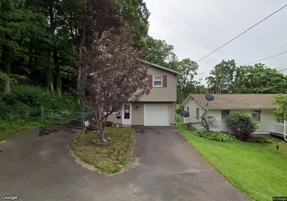
344 Richfield Ave Syracuse, NY 13205
South Valley NeighborhoodEstimated Value: $184,000 - $242,000
3
Beds
1
Bath
1,864
Sq Ft
$110/Sq Ft
Est. Value
About This Home
This home is located at 344 Richfield Ave, Syracuse, NY 13205 and is currently estimated at $205,838, approximately $110 per square foot. 344 Richfield Ave is a home located in Onondaga County with nearby schools including Meachem Elementary School, Clary Middle School, and Corcoran High School.
Ownership History
Date
Name
Owned For
Owner Type
Purchase Details
Closed on
Oct 28, 2011
Sold by
Heins Jr. Paul J
Bought by
Heins Jr. Paul J
Current Estimated Value
Purchase Details
Closed on
Jan 27, 2011
Sold by
Citimortgage Inc
Bought by
Secretary Of Housing
Purchase Details
Closed on
May 21, 2010
Sold by
Steele Leslie
Bought by
Citimortgage Inc
Purchase Details
Closed on
Dec 18, 2002
Sold by
Sutliff William A
Bought by
Steele Leslie C
Create a Home Valuation Report for This Property
The Home Valuation Report is an in-depth analysis detailing your home's value as well as a comparison with similar homes in the area
Home Values in the Area
Average Home Value in this Area
Purchase History
| Date | Buyer | Sale Price | Title Company |
|---|---|---|---|
| Heins Jr. Paul J | -- | James M. Nicholson | |
| Heins Paul | $47,113 | -- | |
| Secretary Of Housing | -- | -- | |
| Citimortgage Inc | $77,924 | -- | |
| Steele Leslie C | $79,000 | Todd Engel |
Source: Public Records
Tax History Compared to Growth
Tax History
| Year | Tax Paid | Tax Assessment Tax Assessment Total Assessment is a certain percentage of the fair market value that is determined by local assessors to be the total taxable value of land and additions on the property. | Land | Improvement |
|---|---|---|---|---|
| 2024 | -- | $70,000 | $17,200 | $52,800 |
| 2023 | $1,228 | $70,000 | $17,200 | $52,800 |
| 2022 | $1,170 | $70,000 | $17,200 | $52,800 |
| 2021 | $1,170 | $63,000 | $17,200 | $45,800 |
| 2020 | $1,031 | $47,100 | $17,200 | $29,900 |
| 2019 | $1,028 | $47,100 | $17,200 | $29,900 |
| 2018 | $1,028 | $47,100 | $17,200 | $29,900 |
| 2017 | $987 | $47,100 | $17,200 | $29,900 |
| 2016 | $1,001 | $47,100 | $17,200 | $29,900 |
| 2015 | -- | $47,100 | $17,200 | $29,900 |
| 2014 | -- | $47,100 | $17,200 | $29,900 |
Source: Public Records
Map
Nearby Homes
- 206 Brampton Rd
- 339 Lafayette Rd
- 127 W Warrington Rd
- 136 Weymouth Rd
- 127 Thurlow Dr
- 118 Ruhamah Ave
- 227 Weymouth Rd
- 202 W Warrington Rd
- 144 Everingham Rd
- 210 Ruhamah Ave
- 217 Ruhamah Ave
- 108 Norman Ave
- 217 Hoover Dr
- 220 Hoover Dr
- 302 Everingham Rd
- 324 E Seneca Turnpike
- 199 Leonard Ave
- 110 Wendell Ave
- 144 W Roswell Ave
- 108 Meredith Ave
- 336 Richfield Ave
- 330 Richfield Ave
- 303 Maplewood Ave
- 400 Richfield Ave
- 326 Richfield Ave
- 337 Richfield Ave
- 345 Richfield Ave
- 241 Maplewood Ave
- 329 Richfield Ave
- 225 Maplewood Ave
- 305 Maplewood Ave
- 318 Richfield Ave
- 300 Maplewood Ave
- 219 Maplewood Ave
- 112 Edgewood Dr
- 215 Maplewood Ave
- 121 Edgewood Dr
- 240 Maplewood Ave
- 315 Richfield Ave
- 315 Richfield Ave Unit 23