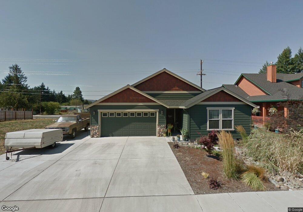
345 Camrin Loop Creswell, OR 97426
Estimated Value: $466,093 - $502,000
3
Beds
2
Baths
1,407
Sq Ft
$339/Sq Ft
Est. Value
About This Home
This home is located at 345 Camrin Loop, Creswell, OR 97426 and is currently estimated at $477,523, approximately $339 per square foot. 345 Camrin Loop is a home located in Lane County with nearby schools including Creslane Elementary School, Creswell Middle School, and Creswell High School.
Ownership History
Date
Name
Owned For
Owner Type
Purchase Details
Closed on
Apr 23, 2009
Sold by
New Era Homes Llc
Bought by
Irvin Stacie and Irvin Daniel
Current Estimated Value
Home Financials for this Owner
Home Financials are based on the most recent Mortgage that was taken out on this home.
Original Mortgage
$240,562
Outstanding Balance
$152,070
Interest Rate
5.02%
Mortgage Type
FHA
Estimated Equity
$325,453
Purchase Details
Closed on
Nov 19, 2008
Sold by
Kris Johnson Construction Inc
Bought by
New Era Homes Llc
Create a Home Valuation Report for This Property
The Home Valuation Report is an in-depth analysis detailing your home's value as well as a comparison with similar homes in the area
Home Values in the Area
Average Home Value in this Area
Purchase History
| Date | Buyer | Sale Price | Title Company |
|---|---|---|---|
| Irvin Stacie | $245,111 | First American | |
| New Era Homes Llc | $68,000 | Cascade Title Co |
Source: Public Records
Mortgage History
| Date | Status | Borrower | Loan Amount |
|---|---|---|---|
| Open | Irvin Stacie | $240,562 |
Source: Public Records
Tax History
| Year | Tax Paid | Tax Assessment Tax Assessment Total Assessment is a certain percentage of the fair market value that is determined by local assessors to be the total taxable value of land and additions on the property. | Land | Improvement |
|---|---|---|---|---|
| 2025 | $4,117 | $250,845 | -- | -- |
| 2024 | $3,080 | $243,539 | -- | -- |
| 2023 | $3,080 | $236,446 | $0 | $0 |
| 2022 | $3,317 | $229,560 | $0 | $0 |
| 2021 | $3,204 | $222,874 | $0 | $0 |
| 2020 | $3,159 | $216,383 | $0 | $0 |
| 2019 | $3,090 | $210,081 | $0 | $0 |
| 2018 | $3,047 | $198,022 | $0 | $0 |
| 2017 | $2,955 | $198,022 | $0 | $0 |
| 2016 | $3,027 | $192,254 | $0 | $0 |
| 2015 | $2,917 | $186,654 | $0 | $0 |
| 2014 | $2,893 | $181,217 | $0 | $0 |
Source: Public Records
Map
Nearby Homes
- 332 Owens Way
- 28 Sandalwood Loop
- 33465 Irish Ln
- 156 N 1st St
- 689 Blue Jay Loop
- 83354 N Pacific Hwy
- 524 N 5th St
- 460 Meadow Ln
- 700 N Mill St Unit 112
- 700 N Mill St Unit 1
- 700 N Mill St Unit 107
- 276 Art Lott Ln
- 1137 Ash Grove Loop
- 958 Bush Ln
- 272 S 7th St
- 395 Ironwood Loop
- 685 St Andrews Loop
- 1237 Spyglass Ct
- 630 S 10th St
- 1 Queens Ave Unit 1
- 341 Camrin Loop
- 350 Camrin Loop
- 337 Camrin Loop
- 342 Camrin Loop
- 354 Camrin Loop
- 349 Camrin Loop
- 338 Camrin Loop
- 331 Camrin Loop
- 358 Camrin Loop
- 318 Camrin Loop
- 362 Camrin Loop
- 83416 N Harvey Rd
- 83419 N Harvey Rd
- 323 Camrin Loop
- 366 Camrin Loop
- 319 Camrin Loop
- 314 Camrin Loop
- 373 Camrin Loop
- 392 Owens Way
- 83405 N Harvey Rd
Your Personal Tour Guide
Ask me questions while you tour the home.