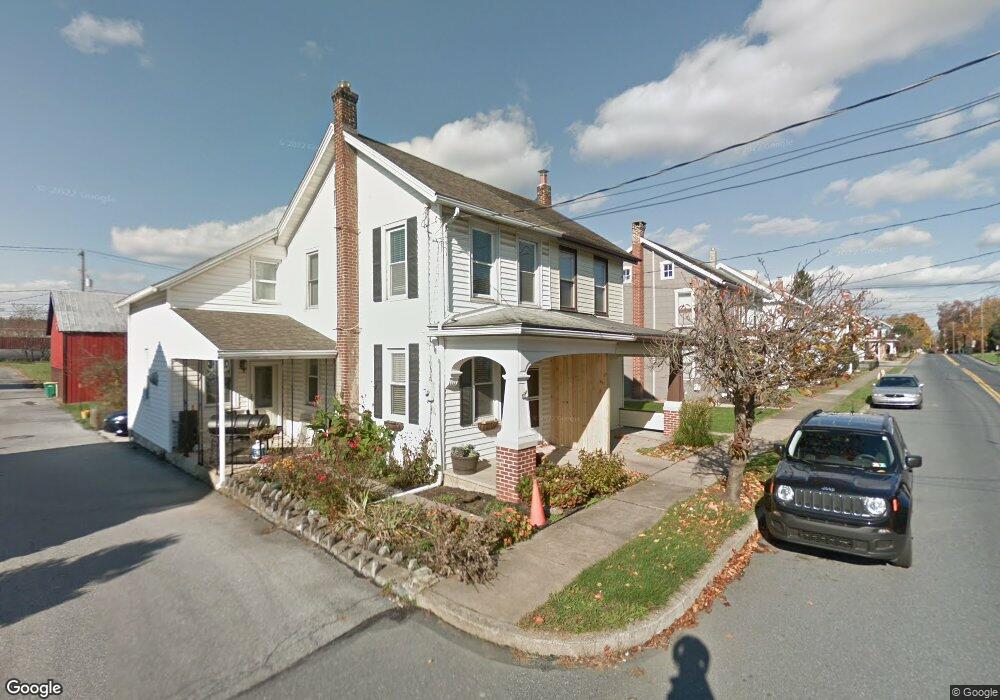
345 E Derry Rd Hershey, PA 17033
Estimated Value: $161,763 - $257,000
3
Beds
1
Bath
702
Sq Ft
$282/Sq Ft
Est. Value
About This Home
This home is located at 345 E Derry Rd, Hershey, PA 17033 and is currently estimated at $198,191, approximately $282 per square foot. 345 E Derry Rd is a home located in Dauphin County with nearby schools including Hershey Elementary School, Hershey Primary Elementary School, and Hershey Middle School.
Ownership History
Date
Name
Owned For
Owner Type
Purchase Details
Closed on
Dec 6, 2006
Sold by
Miller Timothjy B
Bought by
Olney Ethan H
Current Estimated Value
Home Financials for this Owner
Home Financials are based on the most recent Mortgage that was taken out on this home.
Original Mortgage
$83,250
Outstanding Balance
$50,021
Interest Rate
6.4%
Mortgage Type
New Conventional
Estimated Equity
$148,170
Purchase Details
Closed on
Jun 21, 2006
Sold by
Deutsche Bank National Tr
Bought by
Miller Timothy B
Home Financials for this Owner
Home Financials are based on the most recent Mortgage that was taken out on this home.
Original Mortgage
$64,125
Interest Rate
6.67%
Mortgage Type
New Conventional
Create a Home Valuation Report for This Property
The Home Valuation Report is an in-depth analysis detailing your home's value as well as a comparison with similar homes in the area
Home Values in the Area
Average Home Value in this Area
Purchase History
| Date | Buyer | Sale Price | Title Company |
|---|---|---|---|
| Olney Ethan H | $111,000 | -- | |
| Miller Timothy B | $67,500 | -- |
Source: Public Records
Mortgage History
| Date | Status | Borrower | Loan Amount |
|---|---|---|---|
| Open | Olney Ethan H | $83,250 | |
| Previous Owner | Miller Timothy B | $64,125 |
Source: Public Records
Tax History
| Year | Tax Paid | Tax Assessment Tax Assessment Total Assessment is a certain percentage of the fair market value that is determined by local assessors to be the total taxable value of land and additions on the property. | Land | Improvement |
|---|---|---|---|---|
| 2025 | $1,563 | $50,000 | $26,300 | $23,700 |
| 2024 | $1,469 | $50,000 | $26,300 | $23,700 |
| 2023 | $1,442 | $50,000 | $26,300 | $23,700 |
| 2022 | $1,411 | $50,000 | $26,300 | $23,700 |
| 2021 | $1,411 | $50,000 | $26,300 | $23,700 |
| 2020 | $1,411 | $50,000 | $26,300 | $23,700 |
| 2019 | $1,385 | $50,000 | $26,300 | $23,700 |
| 2018 | $1,348 | $50,000 | $26,300 | $23,700 |
| 2017 | $1,348 | $50,000 | $26,300 | $23,700 |
| 2016 | $0 | $50,000 | $26,300 | $23,700 |
| 2015 | -- | $50,000 | $26,300 | $23,700 |
| 2014 | -- | $50,000 | $26,300 | $23,700 |
Source: Public Records
Map
Nearby Homes
- 348 E Derry Rd
- 308 E Derry Rd
- 804 E Chocolate Ave
- 229 Cocoa Ave
- 118 Elm Ave
- 147 Elm Ave
- 251 Maple Ave
- 319 Cedar Ave
- 419 W Areba Ave
- 420 Cedar Ave
- 15 W Governor Rd
- 519 Cedar Ave
- 46 W Governor Rd
- 125 N Roosevelt
- 29 Almond Dr
- 81 Locust Ave
- 228 Hockersville Rd
- 212 E Canal St
- 962 W Areba Ave
- 33 Sterling Ct
- 351 E Derry Rd
- 347 E Derry Rd Unit REAR
- 347 E Derry Rd
- 347 E Derry Rd
- 339 E Derry Rd
- 339 E Derry Rd
- 353 E Derry Rd
- 335 E Derry Rd
- 355 E Derry Rd
- 14 Center Rd Unit 2
- 14 Center Rd Unit 1
- 357 E Derry Rd
- 361 E Derry Rd
- 327 E Derry Rd
- 346 E Derry Rd
- 338 E Derry Rd
- 336 E Derry Rd
- 356 E Derry Rd
- 332 E Derry Rd
- 20 Center Rd
Your Personal Tour Guide
Ask me questions while you tour the home.