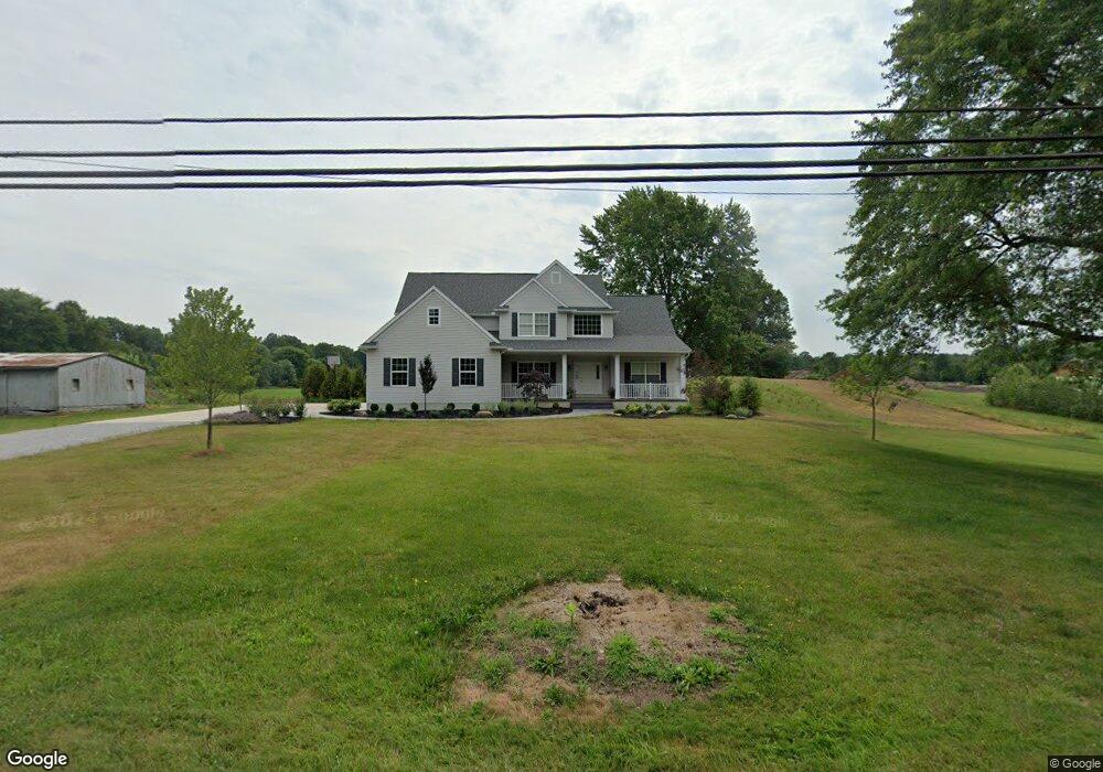
3454 State Route 44 Rootstown, OH 44272
Estimated Value: $427,000 - $465,810
3
Beds
2
Baths
2,834
Sq Ft
$159/Sq Ft
Est. Value
About This Home
This home is located at 3454 State Route 44, Rootstown, OH 44272 and is currently estimated at $451,703, approximately $159 per square foot. 3454 State Route 44 is a home located in Portage County with nearby schools including Rootstown Middle School - Schnee Building and Rootstown High School.
Ownership History
Date
Name
Owned For
Owner Type
Purchase Details
Closed on
Mar 19, 2021
Sold by
Kline David R and Kline Mary Lou
Bought by
Kline Robert R
Current Estimated Value
Purchase Details
Closed on
Sep 28, 2020
Sold by
Estate Of James Allen Kline
Bought by
Kline David R and Kline Mary Lou
Purchase Details
Closed on
Aug 31, 2007
Sold by
Adair Newell Ralph and Adair Michele Marie
Bought by
Kline James A
Home Financials for this Owner
Home Financials are based on the most recent Mortgage that was taken out on this home.
Original Mortgage
$101,100
Interest Rate
6.72%
Mortgage Type
Purchase Money Mortgage
Purchase Details
Closed on
Apr 21, 2003
Sold by
Adair Newell Ralph and Adair Nate Charles
Bought by
Adair Newell Ralph and Adair Michele Marie
Purchase Details
Closed on
May 10, 1994
Bought by
Adair Eileen M
Create a Home Valuation Report for This Property
The Home Valuation Report is an in-depth analysis detailing your home's value as well as a comparison with similar homes in the area
Purchase History
| Date | Buyer | Sale Price | Title Company |
|---|---|---|---|
| Kline Robert R | -- | Murdock Chad | |
| Kline David R | -- | None Available | |
| Kline James A | $95,000 | Approved Statewide Title | |
| Adair Newell Ralph | -- | -- | |
| Adair Eileen M | -- | -- |
Source: Public Records
Mortgage History
| Date | Status | Borrower | Loan Amount |
|---|---|---|---|
| Previous Owner | Kline James A | $101,100 |
Source: Public Records
Tax History
| Year | Tax Paid | Tax Assessment Tax Assessment Total Assessment is a certain percentage of the fair market value that is determined by local assessors to be the total taxable value of land and additions on the property. | Land | Improvement |
|---|---|---|---|---|
| 2025 | $6,773 | $161,420 | $17,640 | $143,780 |
| 2024 | $6,516 | $161,420 | $17,640 | $143,780 |
| 2023 | $4,044 | $89,010 | $15,540 | $73,470 |
| 2022 | $1,390 | $29,860 | $15,540 | $14,320 |
| 2021 | $1,378 | $29,790 | $15,470 | $14,320 |
| 2020 | $1,270 | $26,890 | $14,740 | $12,150 |
| 2019 | $1,274 | $26,890 | $14,740 | $12,150 |
| 2018 | $1,383 | $27,790 | $15,680 | $12,110 |
| 2017 | $1,383 | $27,790 | $15,680 | $12,110 |
| 2016 | $1,350 | $27,790 | $15,680 | $12,110 |
| 2015 | $1,365 | $27,790 | $15,680 | $12,110 |
| 2014 | $1,390 | $27,790 | $15,680 | $12,110 |
| 2013 | $1,381 | $27,790 | $15,680 | $12,110 |
Source: Public Records
Map
Nearby Homes
- 3701 State Route 44
- 3689 Cherry Hill
- 4079 Siefer Dr
- 3637 Old Forge Rd
- 3021 Hartville Rd
- 3981 March Creek Ln Unit 37
- V/L 2 Lynn Rd
- V/L Lynn Rd
- 4200 Hattrick Rd
- 4415 Farmette Dr
- 3080 Saxe Rd
- 4958 Bassett Rd
- sub lot Lane Ave
- 4556 Rootstown Rd
- 3583 Randolph Rd
- 4140 Sandy Lake Rd
- 4324 Abbey Ln
- 4184 Hunters Ridge Dr
- 0 Waterloo Rd
- 4058 Bayberry Knoll Ln
- 3463 State Route 44
- 3443 State Route 44
- 3471 State Route 44
- 3501 State Route 44
- 3425 State Route 44
- 3415 Ohio 44
- 3415 State Route 44
- 3515 State Route 44
- 3407 State Route 44
- 3399 State Route 44
- 3390 State Route 44
- 3541 State Route 44
- 3391 State Route 44
- 3547 State Route 44
- 3383 State Route 44
- 3551 State Route 44
- 3373 State Route 44
- 3360 State Route 44
- 3559 State Route 44
- 3365 State Route 44
Your Personal Tour Guide
Ask me questions while you tour the home.