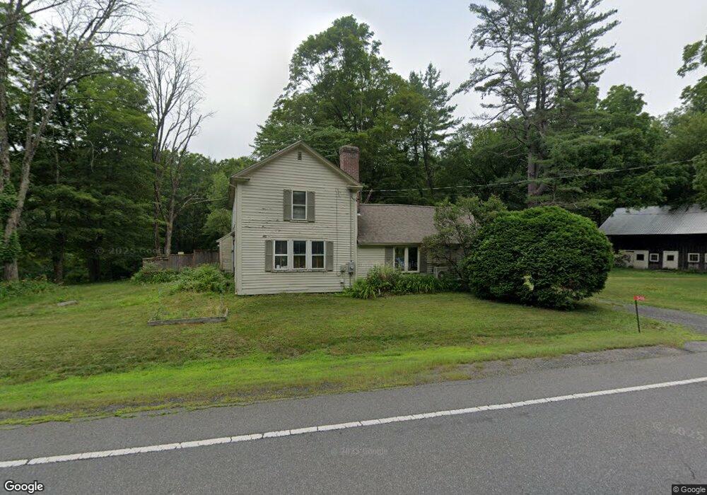
346 Long Plain Rd Leverett, MA 01054
Estimated Value: $508,914 - $665,000
3
Beds
2
Baths
1,990
Sq Ft
$292/Sq Ft
Est. Value
About This Home
This home is located at 346 Long Plain Rd, Leverett, MA 01054 and is currently estimated at $580,979, approximately $291 per square foot. 346 Long Plain Rd is a home located in Franklin County with nearby schools including Leverett Elementary School, Amherst Regional Middle School, and Amherst Regional High School.
Ownership History
Date
Name
Owned For
Owner Type
Purchase Details
Closed on
Apr 29, 2020
Sold by
Levine Daniel M and Neumann Shirah R
Bought by
Levine Daniel M
Current Estimated Value
Home Financials for this Owner
Home Financials are based on the most recent Mortgage that was taken out on this home.
Original Mortgage
$222,000
Outstanding Balance
$195,859
Interest Rate
3.3%
Mortgage Type
New Conventional
Estimated Equity
$385,120
Purchase Details
Closed on
Nov 10, 2016
Sold by
Putnam Donald R and Putnam Marilyn J
Bought by
Levine Daniel M and Neumann Shirah R
Home Financials for this Owner
Home Financials are based on the most recent Mortgage that was taken out on this home.
Original Mortgage
$236,800
Interest Rate
3.42%
Mortgage Type
New Conventional
Purchase Details
Closed on
Oct 1, 1980
Bought by
Putnam Donald R and Putnam Marilyn J
Create a Home Valuation Report for This Property
The Home Valuation Report is an in-depth analysis detailing your home's value as well as a comparison with similar homes in the area
Home Values in the Area
Average Home Value in this Area
Purchase History
| Date | Buyer | Sale Price | Title Company |
|---|---|---|---|
| Levine Daniel M | -- | None Available | |
| Levine Daniel M | $315,000 | -- | |
| Putnam Donald R | $46,000 | -- |
Source: Public Records
Mortgage History
| Date | Status | Borrower | Loan Amount |
|---|---|---|---|
| Open | Levine Daniel M | $222,000 | |
| Previous Owner | Levine Daniel M | $236,800 | |
| Previous Owner | Putnam Donald R | $64,572 | |
| Previous Owner | Putnam Donald R | $100,000 |
Source: Public Records
Tax History
| Year | Tax Paid | Tax Assessment Tax Assessment Total Assessment is a certain percentage of the fair market value that is determined by local assessors to be the total taxable value of land and additions on the property. | Land | Improvement |
|---|---|---|---|---|
| 2025 | $5,782 | $380,900 | $83,100 | $297,800 |
| 2024 | $5,433 | $345,600 | $83,100 | $262,500 |
| 2023 | $5,668 | $353,800 | $95,500 | $258,300 |
| 2022 | $6,170 | $327,500 | $89,800 | $237,700 |
| 2021 | $5,941 | $301,100 | $85,600 | $215,500 |
| 2020 | $6,092 | $297,300 | $85,600 | $211,700 |
| 2019 | $6,023 | $288,300 | $76,600 | $211,700 |
| 2018 | $6,069 | $288,300 | $76,600 | $211,700 |
| 2017 | $6,040 | $288,300 | $76,600 | $211,700 |
| 2016 | $5,884 | $288,300 | $76,600 | $211,700 |
| 2015 | $5,731 | $288,300 | $76,600 | $211,700 |
Source: Public Records
Map
Nearby Homes
- 260 Montague Rd
- 10 Depot Rd
- 100 Depot Rd
- 10 Hannabrooke Dr
- 0 Dudleyville Rd
- 26 Falls Rd
- 35 A N Leverett Rd
- 113 Juggler Meadow Rd
- Lot A January Hills Rd
- 0 Pocumtuck Dr Unit 73379330
- 27 West St
- 38 S Plain Rd
- 18 Stage Rd
- 6 Shattuck Rd
- 59 N Hillside Rd
- 15 Crestview Dr
- 85 Lake Dr
- 84 Lake Dr
- 0 Shore Dr
- 12 Ferry Rd
- 362 Long Plain Rd
- 340 Long Plain Rd
- 335 Long Plain Rd
- 336 Long Plain Rd
- LOT 0 Long Plain Rd
- 334 Long Plain Rd
- 330 Long Plain Rd
- 331 Long Plain Rd
- 327 Long Plain Rd
- 332 Long Plain Rd
- 332 Long Plain Rd
- 323 Long Plain Rd
- 316 Long Plain Rd
- 318 Long Plain Rd
- 312 Long Plain Rd Unit 314
- 312 Long Plain Rd
- 315 Long Plain Rd
- 334-336 Long Plain Rd
- 312-314 Long Plain Rd
- 410 Long Plain Rd
Your Personal Tour Guide
Ask me questions while you tour the home.