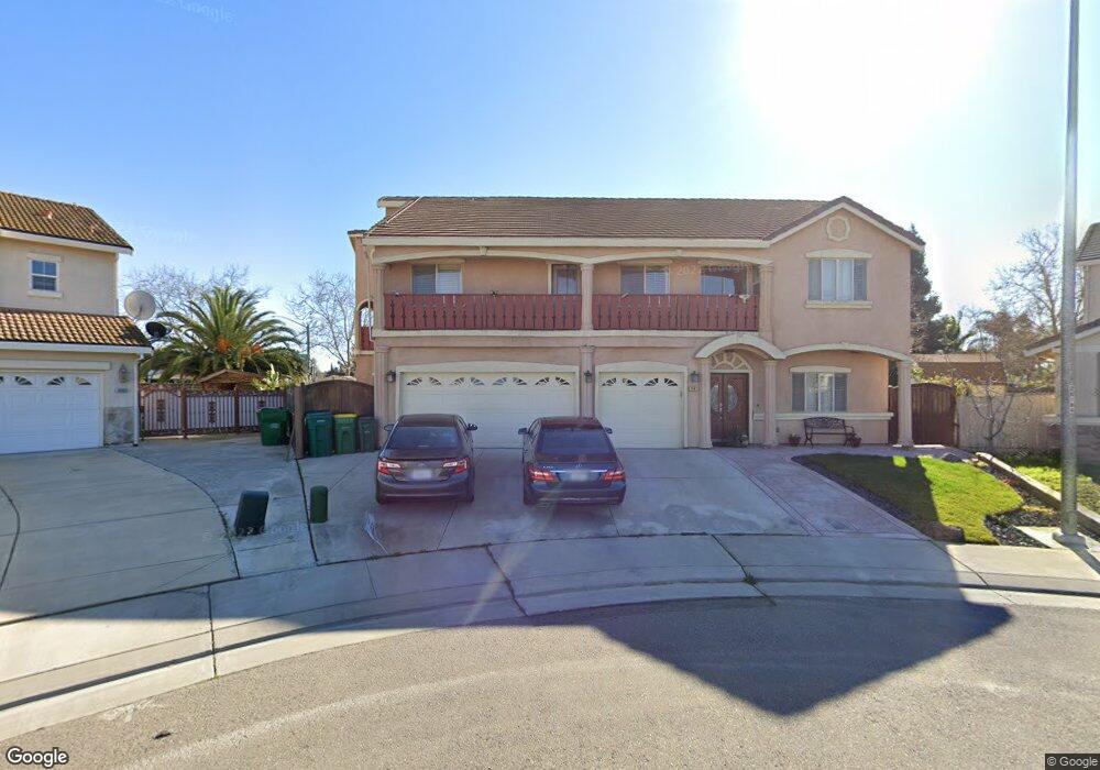
3462 Rutherford Dr Stockton, CA 95212
Valley Oak NeighborhoodEstimated Value: $524,000 - $786,000
5
Beds
4
Baths
4,362
Sq Ft
$160/Sq Ft
Est. Value
About This Home
This home is located at 3462 Rutherford Dr, Stockton, CA 95212 and is currently estimated at $697,711, approximately $159 per square foot. 3462 Rutherford Dr is a home located in San Joaquin County with nearby schools including Ansel Adams School, Morada Middle School, and Ronald E. McNair High School.
Ownership History
Date
Name
Owned For
Owner Type
Purchase Details
Closed on
Apr 11, 2014
Sold by
Concepcion Edgardo R and Concepcion Violeta S
Bought by
Yadav Indravadan
Current Estimated Value
Home Financials for this Owner
Home Financials are based on the most recent Mortgage that was taken out on this home.
Original Mortgage
$185,000
Outstanding Balance
$140,688
Interest Rate
4.35%
Mortgage Type
New Conventional
Estimated Equity
$557,023
Purchase Details
Closed on
Sep 17, 2002
Sold by
Dunmore Homes Llc
Bought by
Yadav Indra and Yadav Savitri
Create a Home Valuation Report for This Property
The Home Valuation Report is an in-depth analysis detailing your home's value as well as a comparison with similar homes in the area
Home Values in the Area
Average Home Value in this Area
Purchase History
| Date | Buyer | Sale Price | Title Company |
|---|---|---|---|
| Yadav Indravadan | $300,000 | North American Title Company | |
| Yadav Indra | $60,000 | Central Valley Title Company |
Source: Public Records
Mortgage History
| Date | Status | Borrower | Loan Amount |
|---|---|---|---|
| Open | Yadav Indravadan | $185,000 |
Source: Public Records
Tax History Compared to Growth
Tax History
| Year | Tax Paid | Tax Assessment Tax Assessment Total Assessment is a certain percentage of the fair market value that is determined by local assessors to be the total taxable value of land and additions on the property. | Land | Improvement |
|---|---|---|---|---|
| 2025 | $7,550 | $622,780 | $86,891 | $535,889 |
| 2024 | $7,411 | $610,570 | $85,188 | $525,382 |
| 2023 | $7,309 | $598,599 | $83,518 | $515,081 |
| 2022 | $7,146 | $586,863 | $81,881 | $504,982 |
| 2021 | $7,280 | $575,357 | $80,276 | $495,081 |
| 2020 | $7,161 | $569,458 | $79,453 | $490,005 |
| 2019 | $6,960 | $558,294 | $77,896 | $480,398 |
| 2018 | $6,196 | $492,000 | $90,000 | $402,000 |
| 2017 | $5,624 | $447,000 | $62,000 | $385,000 |
| 2016 | $5,468 | $447,000 | $62,000 | $385,000 |
| 2014 | $5,269 | $508,050 | $70,886 | $437,164 |
Source: Public Records
Map
Nearby Homes
- 8061 Shay Cir
- 3484 Cathedral Cir
- 8169 Shay Cir
- 9126 Verdicchio Ct
- 8517 Kenny Ct
- 9253 Bridalveil Cir
- 9042 Chianti Cir
- 9308 Pioneer Cir
- 8837 Fox Creek Dr Unit 1
- 8916 Fox Creek Dr
- 8904 Fox Creek Dr Unit 84
- 7849 Moreland St
- 8007 Lorraine Ave
- 2810 Auto Center Cir
- 9332 Kirkby Ln
- 9321 Kirkby Ln
- 2619 Claridge Ln
- 7112 Tristan Cir
- 7127 Tristan Cir Unit 10
- 6052 Saxton Ct
- 3456 Rutherford Dr
- 3453 Rutherford Dr
- 3445 Rutherford Dr
- 3442 Rutherford Dr
- 8443 Clifford Dr
- 8508 Hornsby Dr
- 8438 Clifford Dr
- 8520 Hornsby Dr
- 3437 Rutherford Dr
- 8431 Clifford Dr
- 8532 Hornsby Dr
- 3362 Bryant Dr
- 8426 Clifford Dr
- 3429 Rutherford Dr
- 3421 Rutherford Dr
- 8419 Clifford Dr
- 5832 Hornsby Dr
- 3413 Rutherford Dr
- 3355 Bryant Dr
- 3354 Bryant Dr