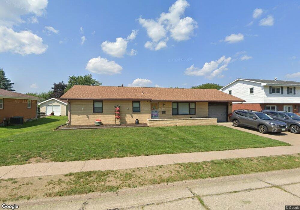
3465 Daniels St Dubuque, IA 52002
Estimated Value: $250,339 - $276,000
3
Beds
2
Baths
1,394
Sq Ft
$188/Sq Ft
Est. Value
About This Home
This home is located at 3465 Daniels St, Dubuque, IA 52002 and is currently estimated at $262,585, approximately $188 per square foot. 3465 Daniels St is a home located in Dubuque County with nearby schools including Hoover Elementary School, Eleanor Roosevelt Middle School, and Hempstead High School.
Ownership History
Date
Name
Owned For
Owner Type
Purchase Details
Closed on
Dec 17, 2010
Sold by
Niensteadt Bernice C
Bought by
Searles Hillary
Current Estimated Value
Home Financials for this Owner
Home Financials are based on the most recent Mortgage that was taken out on this home.
Original Mortgage
$100,000
Outstanding Balance
$66,068
Interest Rate
4.22%
Mortgage Type
New Conventional
Estimated Equity
$196,517
Purchase Details
Closed on
Apr 18, 2007
Sold by
Niensteadt Bernice C
Bought by
The Bernice C Niensteadt Revocable Livin
Create a Home Valuation Report for This Property
The Home Valuation Report is an in-depth analysis detailing your home's value as well as a comparison with similar homes in the area
Purchase History
| Date | Buyer | Sale Price | Title Company |
|---|---|---|---|
| Searles Hillary | $125,000 | None Available | |
| The Bernice C Niensteadt Revocable Livin | -- | None Available |
Source: Public Records
Mortgage History
| Date | Status | Borrower | Loan Amount |
|---|---|---|---|
| Open | Searles Hillary | $100,000 |
Source: Public Records
Tax History
| Year | Tax Paid | Tax Assessment Tax Assessment Total Assessment is a certain percentage of the fair market value that is determined by local assessors to be the total taxable value of land and additions on the property. | Land | Improvement |
|---|---|---|---|---|
| 2025 | $2,742 | $236,700 | $47,800 | $188,900 |
| 2024 | $2,742 | $200,900 | $41,600 | $159,300 |
| 2023 | $2,658 | $200,900 | $41,600 | $159,300 |
| 2022 | $2,680 | $171,030 | $37,420 | $133,610 |
| 2021 | $2,680 | $171,030 | $37,420 | $133,610 |
| 2020 | $2,532 | $157,350 | $37,420 | $119,930 |
| 2019 | $2,336 | $151,180 | $37,420 | $113,760 |
| 2018 | $2,296 | $134,170 | $37,420 | $96,750 |
| 2017 | $2,328 | $134,170 | $37,420 | $96,750 |
| 2016 | $2,278 | $129,100 | $37,420 | $91,680 |
| 2015 | $2,278 | $129,100 | $37,420 | $91,680 |
| 2014 | $2,168 | $126,470 | $37,420 | $89,050 |
Source: Public Records
Map
Nearby Homes
- 1718 Richie Dr
- 1723 Richie Dr
- 3154 Erie Ct
- 3831 Cora Dr
- 2935 Van Buren St
- 0 Associates Dr
- 2935 Saint Anne Dr
- 2281 Pasadena Dr
- 2191 Graham Cir
- 2201 Del Monaco Dr
- 2315 Pasadena Dr
- 2315 Pasadena Dr
- 2035 Broadlawn Rd
- 1970 Admiral St
- 2185 Broadlawn Rd
- 2995 Asbury Rd
- 3255 Lake Ridge Dr Unit A
- 2290 Theda Dr
- 2844 Oak Meadow Ct
- 4400 Dodge St
- 3469 Daniels St
- 3462 Crestwood Dr
- 3458 Crestwood Dr
- 3447 Daniels St
- 3475 Daniels St
- 3466 Crestwood Dr
- 3448 Crestwood Dr
- 3466 Daniels St
- 3458 Daniels St
- 3472 Crestwood Dr
- 3470 Daniels St
- 3438 Crestwood Dr
- 3431 Daniels St
- 3450 Daniels St
- 3480 Daniels St
- 3434 Daniels St
- 3419 Daniels St
- 3463 Crestwood Dr
- 1605 Westridge Dr
- 3457 Crestwood Dr
Your Personal Tour Guide
Ask me questions while you tour the home.