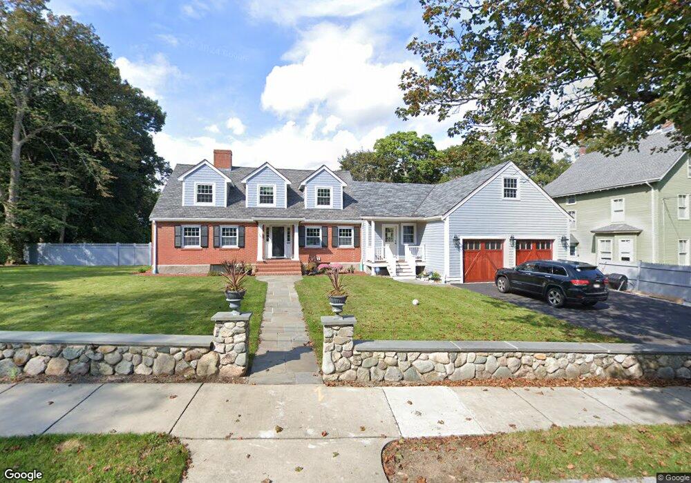
347 Central St Auburndale, MA 02466
Auburndale NeighborhoodEstimated Value: $1,567,000 - $2,492,000
3
Beds
4
Baths
4,916
Sq Ft
$422/Sq Ft
Est. Value
About This Home
This home is located at 347 Central St, Auburndale, MA 02466 and is currently estimated at $2,074,388, approximately $421 per square foot. 347 Central St is a home located in Middlesex County with nearby schools including Williams Elementary School, Charles E Brown Middle School, and Newton South High School.
Ownership History
Date
Name
Owned For
Owner Type
Purchase Details
Closed on
Apr 1, 2002
Sold by
Est Beard Malcolm V Jr and Tabner James V
Bought by
Woodruff Wendy R and Pike Jeffrey
Current Estimated Value
Home Financials for this Owner
Home Financials are based on the most recent Mortgage that was taken out on this home.
Original Mortgage
$495,000
Outstanding Balance
$206,225
Interest Rate
6.88%
Mortgage Type
Purchase Money Mortgage
Estimated Equity
$1,868,163
Purchase Details
Closed on
Sep 7, 1999
Sold by
Malcolm V Beard T and Beard Anne L
Bought by
Beard Malcolm
Home Financials for this Owner
Home Financials are based on the most recent Mortgage that was taken out on this home.
Original Mortgage
$239,600
Interest Rate
7.5%
Mortgage Type
Purchase Money Mortgage
Create a Home Valuation Report for This Property
The Home Valuation Report is an in-depth analysis detailing your home's value as well as a comparison with similar homes in the area
Home Values in the Area
Average Home Value in this Area
Purchase History
| Date | Buyer | Sale Price | Title Company |
|---|---|---|---|
| Woodruff Wendy R | $660,000 | -- | |
| Beard Malcolm | $362,000 | -- |
Source: Public Records
Mortgage History
| Date | Status | Borrower | Loan Amount |
|---|---|---|---|
| Open | Woodruff Wendy R | $495,000 | |
| Previous Owner | Beard Malcolm | $239,600 |
Source: Public Records
Tax History Compared to Growth
Tax History
| Year | Tax Paid | Tax Assessment Tax Assessment Total Assessment is a certain percentage of the fair market value that is determined by local assessors to be the total taxable value of land and additions on the property. | Land | Improvement |
|---|---|---|---|---|
| 2025 | $19,809 | $2,021,300 | $1,268,500 | $752,800 |
| 2024 | $19,153 | $1,962,400 | $1,231,600 | $730,800 |
| 2023 | $15,530 | $1,525,500 | $1,004,800 | $520,700 |
| 2022 | $14,467 | $1,375,200 | $930,400 | $444,800 |
| 2021 | $13,960 | $1,297,400 | $877,700 | $419,700 |
| 2020 | $13,545 | $1,297,400 | $877,700 | $419,700 |
| 2019 | $13,163 | $1,259,600 | $852,100 | $407,500 |
| 2018 | $12,462 | $1,151,800 | $744,100 | $407,700 |
| 2017 | $12,083 | $1,086,600 | $702,000 | $384,600 |
| 2016 | $11,556 | $1,015,500 | $656,100 | $359,400 |
| 2015 | $11,019 | $949,100 | $613,200 | $335,900 |
Source: Public Records
Map
Nearby Homes
- 27 Oakwood Rd
- 17 Lasell St
- 2202 Commonwealth Ave Unit 2
- 2202 Commonwealth Ave Unit 1
- 283 Melrose St
- 224 Auburn St Unit 224
- 224 Auburn St Unit A
- 226 Auburn St Unit 226
- 17 Deforest Rd
- 283 Woodland Rd
- 1754 Washington St
- 62-64 Rowe St Unit B
- 13 Weir St
- 1639 Washington St
- 2084 Washington St
- 51 Bourne St
- 49 Staniford St
- 17 Gilbert St
- 160 Pine St Unit 12
- 103 Loring Rd
- 337 Central St
- 337 Central St Unit C
- 337 Central St Unit D
- 337 Central St Unit Right
- 337 Central St Unit Left
- 337 Central St Unit 1
- 337 Central St Unit 2
- 357 Central St
- 348 Central St
- 329 Central St
- 338 Central St
- 360 Central St
- 9 Oakwood Rd
- 321 Central St
- 330 Central St
- 17 Leighton Rd
- 366 Central St
- 367 Central St
- 324 Central St
- 371 Central St