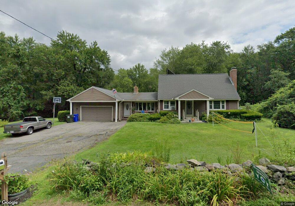
348 Mountain Rd Wilbraham, MA 01095
Estimated Value: $427,000 - $560,000
4
Beds
2
Baths
2,348
Sq Ft
$210/Sq Ft
Est. Value
About This Home
This home is located at 348 Mountain Rd, Wilbraham, MA 01095 and is currently estimated at $492,606, approximately $209 per square foot. 348 Mountain Rd is a home located in Hampden County with nearby schools including Minnechaug Regional High School and Wilbraham & Monson Academy.
Ownership History
Date
Name
Owned For
Owner Type
Purchase Details
Closed on
May 25, 2007
Sold by
Lovell Donna M
Bought by
Smith David L and Peak-Smith Jennifer E
Current Estimated Value
Home Financials for this Owner
Home Financials are based on the most recent Mortgage that was taken out on this home.
Original Mortgage
$205,000
Outstanding Balance
$125,374
Interest Rate
6.27%
Mortgage Type
Purchase Money Mortgage
Estimated Equity
$367,232
Purchase Details
Closed on
Jul 6, 2006
Sold by
Revocable Indenture Of and Lovell Donna M
Bought by
Lovell Donna M
Home Financials for this Owner
Home Financials are based on the most recent Mortgage that was taken out on this home.
Original Mortgage
$130,000
Interest Rate
6.6%
Mortgage Type
Purchase Money Mortgage
Purchase Details
Closed on
Mar 30, 2005
Sold by
Lovell Donna M
Bought by
Revocable Indenture T and Lovell Donna M
Create a Home Valuation Report for This Property
The Home Valuation Report is an in-depth analysis detailing your home's value as well as a comparison with similar homes in the area
Home Values in the Area
Average Home Value in this Area
Purchase History
| Date | Buyer | Sale Price | Title Company |
|---|---|---|---|
| Smith David L | $262,000 | -- | |
| Lovell Donna M | -- | -- | |
| Revocable Indenture T | -- | -- |
Source: Public Records
Mortgage History
| Date | Status | Borrower | Loan Amount |
|---|---|---|---|
| Open | Smith David L | $205,000 | |
| Previous Owner | Lovell Donna M | $130,000 |
Source: Public Records
Tax History
| Year | Tax Paid | Tax Assessment Tax Assessment Total Assessment is a certain percentage of the fair market value that is determined by local assessors to be the total taxable value of land and additions on the property. | Land | Improvement |
|---|---|---|---|---|
| 2025 | $8,039 | $449,600 | $108,900 | $340,700 |
| 2024 | $7,380 | $398,900 | $108,900 | $290,000 |
| 2023 | $7,133 | $372,100 | $108,900 | $263,200 |
| 2022 | $7,133 | $348,100 | $108,900 | $239,200 |
| 2021 | $6,528 | $284,300 | $110,500 | $173,800 |
| 2020 | $6,363 | $284,300 | $110,500 | $173,800 |
| 2019 | $6,200 | $284,400 | $110,500 | $173,900 |
| 2018 | $5,995 | $264,800 | $110,500 | $154,300 |
| 2017 | $5,606 | $254,800 | $110,500 | $144,300 |
| 2016 | $5,311 | $245,900 | $122,200 | $123,700 |
| 2015 | $5,134 | $245,900 | $122,200 | $123,700 |
Source: Public Records
Map
Nearby Homes
- 474-480 Mountain Rd
- 474 Mountain Rd
- 172 Main St
- 20 Old Orchard Rd
- 36 Maple St
- 1 Aspen Dr
- 8 High Pine Cir
- 16 Falcon Heights
- 745 Glendale Rd
- 104 High Pine Cir
- 5 Silver St
- 5v Red Gap Rd
- 35 Lake Dr
- 6 Hilltop Park
- 7 Highridge Rd
- 38 King Dr
- 8 Patriot Ridge Ln
- 80 Elizabeth Dr
- 46 Washington Rd
- 37 Balsam Hill Rd
- 344 Mountain Rd
- 360 Mountain Rd
- 340 Mountain Rd
- 321 Glendale Rd
- 307 Mountain Rd
- 325 Glendale Rd
- 311 Glendale Rd
- 2 Chestnut Hill Rd
- 329 Glendale Rd
- 324 Glendale Rd
- 4 Chestnut Hill Rd
- 331 Glendale Rd
- 330 Glendale Rd
- 312 Glendale Rd
- 356 Mountain Rd
- 298 Glendale Rd
- 375 Mountain Rd
- 301 Mountain Rd
- 5 Chestnut Hill Rd
- 336 Glendale Rd
Your Personal Tour Guide
Ask me questions while you tour the home.