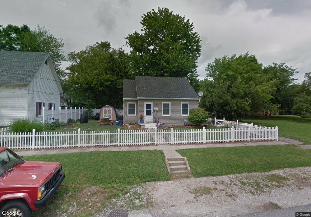
348 Pratt St Franklin, IN 46131
Estimated Value: $206,000 - $249,000
2
Beds
2
Baths
2,056
Sq Ft
$107/Sq Ft
Est. Value
About This Home
This home is located at 348 Pratt St, Franklin, IN 46131 and is currently estimated at $220,570, approximately $107 per square foot. 348 Pratt St is a home located in Johnson County with nearby schools including Northwood Elementary School, Franklin Community Middle School, and Custer Baker Intermediate School.
Ownership History
Date
Name
Owned For
Owner Type
Purchase Details
Closed on
Jan 25, 2022
Sold by
Elizabeth Simmons Teri
Bought by
Simmons Teri Elizabeth and Cratty Leslie Amanda
Current Estimated Value
Purchase Details
Closed on
Oct 30, 2009
Sold by
Leugers Brandon and Leugers Klley
Bought by
Simmons Teri
Home Financials for this Owner
Home Financials are based on the most recent Mortgage that was taken out on this home.
Original Mortgage
$80,514
Interest Rate
4.96%
Mortgage Type
FHA
Create a Home Valuation Report for This Property
The Home Valuation Report is an in-depth analysis detailing your home's value as well as a comparison with similar homes in the area
Home Values in the Area
Average Home Value in this Area
Purchase History
| Date | Buyer | Sale Price | Title Company |
|---|---|---|---|
| Simmons Teri Elizabeth | -- | None Listed On Document | |
| Simmons Teri | -- | None Available |
Source: Public Records
Mortgage History
| Date | Status | Borrower | Loan Amount |
|---|---|---|---|
| Previous Owner | Simmons Teri | $80,514 |
Source: Public Records
Tax History Compared to Growth
Tax History
| Year | Tax Paid | Tax Assessment Tax Assessment Total Assessment is a certain percentage of the fair market value that is determined by local assessors to be the total taxable value of land and additions on the property. | Land | Improvement |
|---|---|---|---|---|
| 2025 | $1,272 | $142,900 | $10,200 | $132,700 |
| 2024 | $1,272 | $121,600 | $10,400 | $111,200 |
| 2023 | $1,037 | $107,300 | $10,400 | $96,900 |
| 2022 | $843 | $91,700 | $10,400 | $81,300 |
| 2021 | $753 | $84,300 | $8,500 | $75,800 |
| 2020 | $543 | $71,800 | $8,500 | $63,300 |
| 2019 | $483 | $66,100 | $8,500 | $57,600 |
| 2018 | $462 | $66,400 | $8,800 | $57,600 |
| 2017 | $447 | $63,200 | $8,800 | $54,400 |
| 2016 | $528 | $68,100 | $8,800 | $59,300 |
| 2014 | $452 | $70,000 | $10,600 | $59,400 |
| 2013 | $452 | $64,200 | $10,600 | $53,600 |
Source: Public Records
Map
Nearby Homes
- 351 Cincinnati St
- 750 Hurricane St
- 651 Hamilton Ave
- 698 Yandes St
- 601 Duane St
- 348 Ohio St
- 298 N Water St
- 150 E King St
- 147 E King St
- 0 W 900 Hwy Unit 202537998
- 484 E Jefferson St
- 123 14th St
- 1110 Hillview Dr
- 227 E Jefferson St
- 199 Walnut St
- 178 S Water St Unit F
- 76 E Wayne St Unit B
- 1624 Roberts Rd
- 991 Ravine Dr
- 252 S Main St