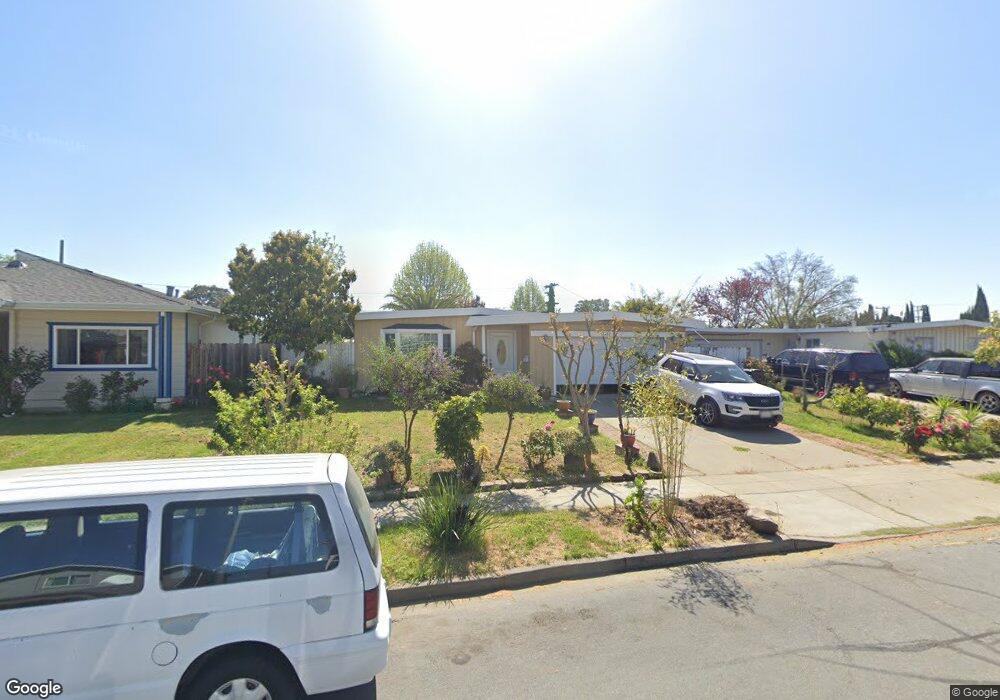
3482 Deodara St Fremont, CA 94538
Downtown Fremont NeighborhoodEstimated Value: $1,231,000 - $1,361,000
3
Beds
2
Baths
1,156
Sq Ft
$1,117/Sq Ft
Est. Value
About This Home
This home is located at 3482 Deodara St, Fremont, CA 94538 and is currently estimated at $1,290,919, approximately $1,116 per square foot. 3482 Deodara St is a home located in Alameda County with nearby schools including J. Haley Durham Elementary School, G.M. Walters Middle School, and John F. Kennedy High School.
Ownership History
Date
Name
Owned For
Owner Type
Purchase Details
Closed on
Apr 30, 2001
Sold by
Snow Raymond M and The Raymond M Snow Family Trus
Bought by
Tenchavez Celso and Valentino Estelita
Current Estimated Value
Home Financials for this Owner
Home Financials are based on the most recent Mortgage that was taken out on this home.
Original Mortgage
$323,850
Outstanding Balance
$120,925
Interest Rate
7.03%
Estimated Equity
$1,169,994
Create a Home Valuation Report for This Property
The Home Valuation Report is an in-depth analysis detailing your home's value as well as a comparison with similar homes in the area
Home Values in the Area
Average Home Value in this Area
Purchase History
| Date | Buyer | Sale Price | Title Company |
|---|---|---|---|
| Tenchavez Celso | $381,000 | Chicago Title Co |
Source: Public Records
Mortgage History
| Date | Status | Borrower | Loan Amount |
|---|---|---|---|
| Open | Tenchavez Celso | $323,850 |
Source: Public Records
Tax History Compared to Growth
Tax History
| Year | Tax Paid | Tax Assessment Tax Assessment Total Assessment is a certain percentage of the fair market value that is determined by local assessors to be the total taxable value of land and additions on the property. | Land | Improvement |
|---|---|---|---|---|
| 2025 | $7,117 | $567,063 | $172,219 | $401,844 |
| 2024 | $7,117 | $555,808 | $168,842 | $393,966 |
| 2023 | $6,919 | $551,774 | $165,532 | $386,242 |
| 2022 | $6,818 | $533,958 | $162,287 | $378,671 |
| 2021 | $6,652 | $523,351 | $159,105 | $371,246 |
| 2020 | $6,636 | $524,914 | $157,474 | $367,440 |
| 2019 | $6,561 | $514,624 | $154,387 | $360,237 |
| 2018 | $6,431 | $504,534 | $151,360 | $353,174 |
| 2017 | $6,270 | $494,644 | $148,393 | $346,251 |
| 2016 | $6,157 | $484,947 | $145,484 | $339,463 |
| 2015 | $6,070 | $477,667 | $143,300 | $334,367 |
| 2014 | $5,961 | $468,313 | $140,494 | $327,819 |
Source: Public Records
Map
Nearby Homes
- 3695 Stevenson Blvd Unit E206
- 3909 Stevenson Blvd Unit 402
- 39993 Fremont Blvd Unit 102
- 3583 Madison Common
- 3454 Dayton Common
- 40469 Shaw Ct
- 3455 Gilman Common
- 39751 Bissy Common
- 39753 Placer Way
- 39455 Albany Common Unit V
- 1960 Barrymore Common Unit K
- 4350 Millard Ave
- 40425 Chapel Way Unit 214
- 40425 Chapel Way Unit 309
- 1910 Barrymore Common Unit C
- 40708 Fremont Blvd
- 40769 Squill Common
- 4421 Cahill St
- 40702 Greystone Terrace Unit 9
- 4453 Porter St
- 3470 Deodara St
- 3481 Little Ct
- 3458 Deodara St
- 3469 Little Ct
- 3493 Little Ct
- 3457 Little Ct
- 3388 Deodara St
- 3483 Deodara St
- 3471 Deodara St
- 3495 Deodara St
- 40047 Leslie St
- 40035 Leslie St
- 3445 Little Ct
- 3459 Deodara St
- 40059 Leslie St
- 40023 Leslie St
- 3376 Deodara St
- 40071 Leslie St
- 39991 Leslie St
- 3387 Deodara St