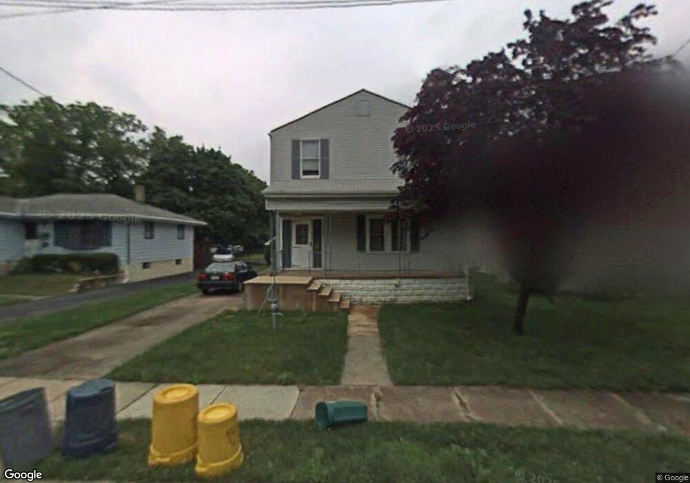
35 Anna Ave Maple Shade, NJ 08052
Estimated Value: $348,000 - $433,000
--
Bed
--
Bath
1,834
Sq Ft
$220/Sq Ft
Est. Value
About This Home
This home is located at 35 Anna Ave, Maple Shade, NJ 08052 and is currently estimated at $402,982, approximately $219 per square foot. 35 Anna Ave is a home located in Burlington County with nearby schools including Maude M. Wilkins Elementary School, Ralph J Steinhauer Elementary School, and Howard R Yocum School.
Ownership History
Date
Name
Owned For
Owner Type
Purchase Details
Closed on
Jan 14, 2002
Sold by
Hud
Bought by
Onori Mark M
Current Estimated Value
Home Financials for this Owner
Home Financials are based on the most recent Mortgage that was taken out on this home.
Original Mortgage
$116,850
Outstanding Balance
$47,886
Interest Rate
7.08%
Mortgage Type
Stand Alone First
Estimated Equity
$355,096
Purchase Details
Closed on
Sep 19, 2001
Sold by
Foy John P and Foy Lois
Bought by
Hud
Purchase Details
Closed on
Sep 24, 1996
Sold by
Kennedy Ronald F and Kennedy Milissa A
Bought by
Foy John P
Home Financials for this Owner
Home Financials are based on the most recent Mortgage that was taken out on this home.
Original Mortgage
$111,912
Interest Rate
8.07%
Mortgage Type
FHA
Create a Home Valuation Report for This Property
The Home Valuation Report is an in-depth analysis detailing your home's value as well as a comparison with similar homes in the area
Home Values in the Area
Average Home Value in this Area
Purchase History
| Date | Buyer | Sale Price | Title Company |
|---|---|---|---|
| Onori Mark M | $123,000 | Old Republic Natl Title Ins | |
| Hud | -- | First American Title Ins Co | |
| Foy John P | $112,126 | Surety Title Corporation |
Source: Public Records
Mortgage History
| Date | Status | Borrower | Loan Amount |
|---|---|---|---|
| Open | Onori Mark M | $116,850 | |
| Previous Owner | Foy John P | $111,912 |
Source: Public Records
Tax History Compared to Growth
Tax History
| Year | Tax Paid | Tax Assessment Tax Assessment Total Assessment is a certain percentage of the fair market value that is determined by local assessors to be the total taxable value of land and additions on the property. | Land | Improvement |
|---|---|---|---|---|
| 2025 | $9,289 | $244,700 | $50,400 | $194,300 |
| 2024 | $9,020 | $244,700 | $50,400 | $194,300 |
| 2023 | $9,020 | $244,700 | $50,400 | $194,300 |
| 2022 | $8,880 | $244,700 | $50,400 | $194,300 |
| 2021 | $8,795 | $244,700 | $50,400 | $194,300 |
| 2020 | $8,819 | $244,700 | $50,400 | $194,300 |
| 2019 | $8,496 | $244,700 | $50,400 | $194,300 |
| 2018 | $8,349 | $244,700 | $50,400 | $194,300 |
| 2017 | $8,251 | $244,700 | $50,400 | $194,300 |
| 2016 | $7,614 | $229,200 | $50,400 | $178,800 |
| 2015 | $7,449 | $229,200 | $50,400 | $178,800 |
| 2014 | $7,222 | $229,200 | $50,400 | $178,800 |
Source: Public Records
Map
Nearby Homes
- 107 S Forklanding Rd
- 57 S Terrace Ave
- 112 S Maple Ave
- 22 Theodore Ave
- 15 N Poplar Ave
- 48 N Terrace Ave
- 29 W Broadway
- 2 Gainor Ave
- 410 S Forklanding Rd
- 52 S Fellowship Rd
- 19 S Chestnut Ave
- 104 E Laurelton Ave
- 19 Farnsworth Ave
- 327 S Coles Ave
- 480 W Front St
- 301 N Coles Ave
- 477 Buttonwood Ave
- 124 Stiles Ave
- 5 Paul Rd
- 44 S Pine Ave