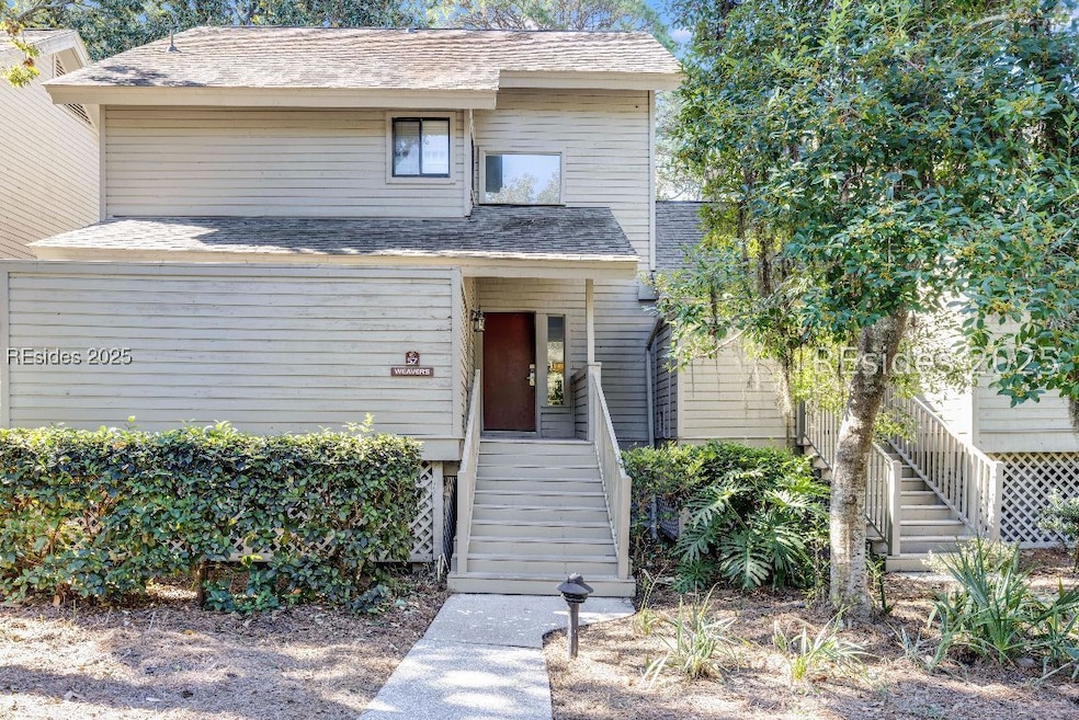

35 Carnoustie Rd Unit 57 Hilton Head Island, SC 29928
Palmetto Dunes NeighborhoodEstimated payment $6,244/month
Highlights
- Community Beach Access
- Boat Dock
- Furnished
- Hilton Head Island High School Rated A-
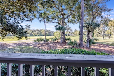
- Golf Course View
- Great Room
About This Home
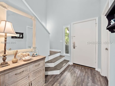
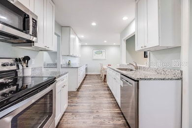
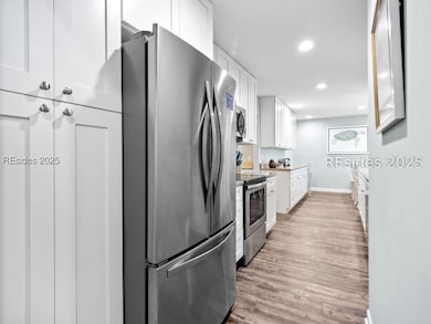
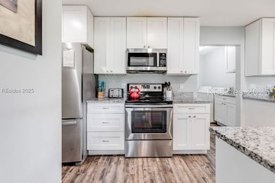
Your Beach Getaway Awaits! Nestled in the heart of Palmetto Dunes World Class Resort, this spacious 3 BR/3 BA townhome offers amazing panoramic golf views, steps to the pool, open floorplan, LVP flooring, granite countertops, self closing cabinets, SS appliances, smooth ceilings, beachy decor, eat-in kitchen, decorative mirrors/lighting, awesome covered back porch plus great outdoor storage. Just a short walk/bike ride to the beach, tennis/pickle ball, Dunes House, General Store, and more! A must see villa!
Townhouse Details
Home Type
- Townhome
Year Built
- Built in 1979
Lot Details
- Northeast Facing Home
- Landscaped
HOA Fees
- $567 Monthly HOA Fees
Parking
- Unassigned Parking
Home Design
- Asphalt Roof
- Wood Siding
- Tile
Interior Spaces
- 2,015 Sq Ft Home
- Furnished
- Ceiling Fan
- Fireplace
- Window Treatments
- Entrance Foyer
- Great Room
- Dining Room
- Utility Room
- Golf Course Views
- Pull Down Stairs to Attic
- Security Gate
Kitchen
- Eat-In Kitchen
- Oven
- Stove
- Dishwasher
- Disposal
Bedrooms and Bathrooms
- 3 Bedrooms
- Primary Bedroom Upstairs
- 3 Full Bathrooms
- Separate Shower
Laundry
- Laundry Room
- Dryer
- Washer
Outdoor Features
- Free Form Pool
- Balcony
Utilities
- Central Heating and Cooling System
- Heat Pump System
- Cable TV Available
Listing and Financial Details
- Tax Lot 57
- Assessor Parcel Number R520-012-000-0357-0057
Community Details
Overview
- Association fees include management, common areas, cable TV, ground maintenance, maintenance structure, pest control, pool(s), sewer, trash, water
- Fazio Villas Subdivision
Recreation
- Boat Dock
- Community Beach Access
- Tennis Courts
- Community Pool
- Trails
Pet Policy
- Only Owners Allowed Pets
Additional Features
- Community Garden
- Security Guard
Map
Home Values in the Area
Average Home Value in this Area
Tax History
| Year | Tax Paid | Tax Assessment Tax Assessment Total Assessment is a certain percentage of the fair market value that is determined by local assessors to be the total taxable value of land and additions on the property. | Land | Improvement |
|---|---|---|---|---|
| 2024 | $8,845 | $34,500 | $0 | $0 |
| 2023 | $8,757 | $34,500 | $0 | $0 |
| 2022 | $7,939 | $30,000 | $0 | $0 |
| 2021 | $6,638 | $24,910 | $0 | $0 |
| 2020 | $6,434 | $24,910 | $0 | $0 |
| 2019 | $6,256 | $24,910 | $0 | $0 |
| 2018 | $5,953 | $24,910 | $0 | $0 |
| 2017 | $6,324 | $25,390 | $0 | $0 |
| 2016 | $6,040 | $25,390 | $0 | $0 |
| 2014 | $4,416 | $25,390 | $0 | $0 |
Property History
| Date | Event | Price | List to Sale | Price per Sq Ft |
|---|---|---|---|---|
| 12/03/2025 12/03/25 | Price Changed | $939,000 | -5.6% | $466 / Sq Ft |
| 10/24/2025 10/24/25 | Price Changed | $995,000 | 0.0% | $494 / Sq Ft |
| 10/24/2025 10/24/25 | For Sale | $995,000 | -- | $494 / Sq Ft |
| 10/10/2025 10/10/25 | Off Market | -- | -- | -- |
Purchase History
| Date | Type | Sale Price | Title Company |
|---|---|---|---|
| Deed | $500,000 | None Available | |
| Warranty Deed | $420,000 | None Available |
Mortgage History
| Date | Status | Loan Amount | Loan Type |
|---|---|---|---|
| Previous Owner | $336,000 | New Conventional |
Source: REsides
MLS Number: 502042
APN: R520-012-000-0357-0057
Disclaimer: Certain information contained herein is derived from information provided by parties other than Homes.com. All information provided is deemed reliable, but is not guaranteed to be accurate and should be independently verified.
![]() We do not attempt to independently verify the currency, completeness, accuracy or authenticity of the data contained herein. All area measurements and calculations are approximate and should be independently verified. Data may be subject to transcription and transmission errors. Accordingly, the data is provided on an “as is” “as available” basis only and may not reflect all real estate activity in the market”. © [2025] REsides, Inc. All rights reserved. Certain information contained herein is derived from information, which is the licensed property of, and copyrighted by, REsides, Inc.
We do not attempt to independently verify the currency, completeness, accuracy or authenticity of the data contained herein. All area measurements and calculations are approximate and should be independently verified. Data may be subject to transcription and transmission errors. Accordingly, the data is provided on an “as is” “as available” basis only and may not reflect all real estate activity in the market”. © [2025] REsides, Inc. All rights reserved. Certain information contained herein is derived from information, which is the licensed property of, and copyrighted by, REsides, Inc.
- 35 Carnoustie Rd Unit 56
- 59 Carnoustie Rd Unit 287
- 59 Carnoustie Rd Unit 241
- 59 Carnoustie Rd Unit 243
- 60 Carnoustie Rd Unit 928
- 60 Carnoustie Rd Unit 983
- 60 Carnoustie Rd Unit 997
- 28 Heath Dr
- 45 Queens Folly Rd Unit 633
- 45 Queens Folly Rd Unit 652
- 45 Queens Folly Rd Unit 529
- 45 Queens Folly Rd Unit 666
- 45 Queens Folly Rd Unit 671
- 45 Queens Folly Rd Unit 677
- 45 Queens Folly Rd Unit 789
- 45 Queens Folly Rd Unit 794
- 20 Queens Folly Rd Unit 1782
- 20 Queens Folly Rd Unit 1667
- 20 Queens Folly Rd Unit 1981
- 20 Queens Folly Rd Unit 1661
- 45 Queens Folly Rd Unit ID1309206P
- 10 Dune House Ln Unit ID1269197P
- 77 Ocean Ln Unit FL1-ID1316255P
- 663 William Hilton Pkwy Unit 2121
- 3 Collier Ct Unit ID1316246P
- 10 Surf Watch Way
- 104 Cordillo Pkwy Unit O1
- 158 Otter Rd
- 23 S Forest Beach Dr Unit ID1316237P
- 23 S Forest Beach Dr Unit ID1316238P
- 52 Sandcastle Ct Unit ID1316234P
- 40 Folly Field Rd Unit HHIBTR #AR416
- 40 Folly Field Rd Unit 141B
- 10 Lemoyne Ave Unit ID1322533P
- 486 Spanish Wells Rd
- 40 Folly Field Rd Unit ID1316233P
- 137 Cordillo Pkwy Unit ID1322534P
- 55 Gardner Dr Unit B1
- 55 Gardner Dr Unit A1
- 55 Gardner Dr Unit A2
