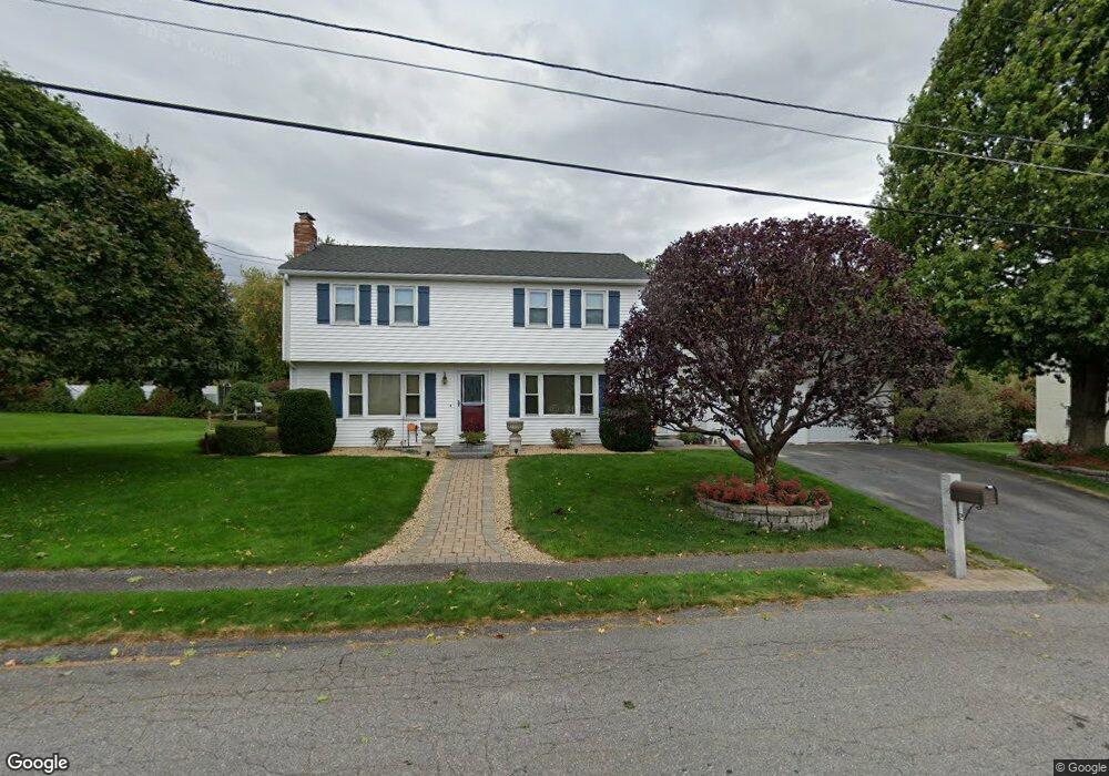
35 Comstock Rd Leominster, MA 01453
Estimated Value: $536,000 - $646,000
4
Beds
3
Baths
2,400
Sq Ft
$250/Sq Ft
Est. Value
About This Home
This home is located at 35 Comstock Rd, Leominster, MA 01453 and is currently estimated at $600,697, approximately $250 per square foot. 35 Comstock Rd is a home located in Worcester County with nearby schools including Leominster High School, St. Anna Catholic School, and St. Leo School.
Ownership History
Date
Name
Owned For
Owner Type
Purchase Details
Closed on
Mar 11, 1998
Sold by
Fatcheric Timothy A and Fatcheric Bethann
Bought by
Casey Sean P and Casey Lynda H
Current Estimated Value
Purchase Details
Closed on
Feb 28, 1991
Sold by
Nolte Gerry F and Nolte Mary Doran
Bought by
Fatcheric Timothy A and Fatcheric Bethann
Create a Home Valuation Report for This Property
The Home Valuation Report is an in-depth analysis detailing your home's value as well as a comparison with similar homes in the area
Home Values in the Area
Average Home Value in this Area
Purchase History
| Date | Buyer | Sale Price | Title Company |
|---|---|---|---|
| Casey Sean P | $170,000 | -- | |
| Fatcheric Timothy A | $149,900 | -- |
Source: Public Records
Mortgage History
| Date | Status | Borrower | Loan Amount |
|---|---|---|---|
| Closed | Fatcheric Timothy A | $165,000 | |
| Closed | Fatcheric Timothy A | $156,000 | |
| Closed | Fatcheric Timothy A | $50,000 |
Source: Public Records
Tax History Compared to Growth
Tax History
| Year | Tax Paid | Tax Assessment Tax Assessment Total Assessment is a certain percentage of the fair market value that is determined by local assessors to be the total taxable value of land and additions on the property. | Land | Improvement |
|---|---|---|---|---|
| 2025 | $7,000 | $498,900 | $157,300 | $341,600 |
| 2024 | $6,894 | $475,100 | $149,700 | $325,400 |
| 2023 | $6,517 | $419,400 | $130,300 | $289,100 |
| 2022 | $6,207 | $374,800 | $113,400 | $261,400 |
| 2021 | $6,032 | $332,700 | $88,200 | $244,500 |
| 2020 | $5,804 | $322,800 | $88,200 | $234,600 |
| 2019 | $5,629 | $303,600 | $83,900 | $219,700 |
| 2018 | $5,583 | $288,800 | $81,400 | $207,400 |
| 2017 | $5,398 | $273,600 | $76,100 | $197,500 |
| 2016 | $5,306 | $271,000 | $76,100 | $194,900 |
| 2015 | $4,879 | $251,000 | $76,100 | $174,900 |
| 2014 | $4,692 | $248,400 | $82,800 | $165,600 |
Source: Public Records
Map
Nearby Homes
- 25 Crimson Ct
- 47 Carolyn St
- 24 Starling Way
- 74 Crisci St
- 12 Walden Ct
- 15 Peach Tree Ln
- 102 Chapman Place Unit 102
- 46 Eugene St
- 28 Dupont Cir
- 41 Hill St
- 35 Hill St
- 871 Pleasant St
- 22 Naples St
- 197 Chapman Place Unit 197
- 6 Argentine St
- 112 Overlook Dr
- 98 Sylvan Ave
- 30 Abbey Rd Unit 207
- 10 Abbey Rd Unit 205
- 30 Abbey Rd Unit 104
- 41 Comstock Rd
- 29 Comstock Rd
- 88 Glenwood Dr
- 82 Glenwood Dr
- 32 Comstock Rd
- 94 Glenwood Dr
- 36 Comstock Rd
- 47 Comstock Rd
- 23 Comstock Rd
- 26 Comstock Rd
- 76 Glenwood Dr
- 42 Comstock Rd
- 100 Glenwood Dr
- 20 Comstock Rd
- 17 Comstock Rd
- 59 Duggan Dr
- 244 Birchcroft Rd
- 87 Glenwood Dr
- 70 Glenwood Dr
- 81 Glenwood Dr