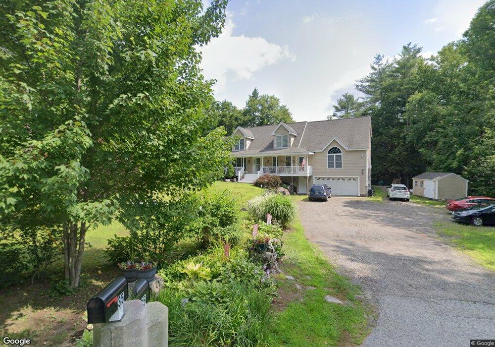
35 Scribner Rd Raymond, NH 03077
Estimated Value: $506,000 - $703,894
5
Beds
4
Baths
3,188
Sq Ft
$200/Sq Ft
Est. Value
About This Home
This home is located at 35 Scribner Rd, Raymond, NH 03077 and is currently estimated at $637,974, approximately $200 per square foot. 35 Scribner Rd is a home located in Rockingham County with nearby schools including Lamprey River Elementary School, Iber Holmes Gove Middle School, and Raymond High School.
Ownership History
Date
Name
Owned For
Owner Type
Purchase Details
Closed on
May 17, 2024
Sold by
Jrtc Rt and Sawyer
Bought by
Janice P Melanson Ret and Melanson
Current Estimated Value
Purchase Details
Closed on
Feb 21, 2020
Sold by
Melanson Janice P
Bought by
Janice P Melanson Ret
Purchase Details
Closed on
Nov 18, 2005
Sold by
Melanson Michael L and Melanson Debra A
Bought by
Melanson Janice P
Create a Home Valuation Report for This Property
The Home Valuation Report is an in-depth analysis detailing your home's value as well as a comparison with similar homes in the area
Home Values in the Area
Average Home Value in this Area
Purchase History
| Date | Buyer | Sale Price | Title Company |
|---|---|---|---|
| Janice P Melanson Ret | $35,000 | None Available | |
| Janice P Melanson Ret | $35,000 | None Available | |
| Janice P Melanson Ret | $35,000 | None Available | |
| Janice P Melanson Ret | -- | None Available | |
| Melanson Janice P | $65,000 | -- | |
| Melanson Janice P | $65,000 | -- |
Source: Public Records
Mortgage History
| Date | Status | Borrower | Loan Amount |
|---|---|---|---|
| Previous Owner | Melanson Janice P | $50,000 |
Source: Public Records
Tax History
| Year | Tax Paid | Tax Assessment Tax Assessment Total Assessment is a certain percentage of the fair market value that is determined by local assessors to be the total taxable value of land and additions on the property. | Land | Improvement |
|---|---|---|---|---|
| 2024 | $10,843 | $494,900 | $118,700 | $376,200 |
| 2023 | $10,254 | $494,900 | $118,700 | $376,200 |
| 2022 | $9,052 | $494,900 | $118,700 | $376,200 |
| 2021 | $9,161 | $494,900 | $118,700 | $376,200 |
| 2020 | $9,377 | $370,200 | $85,200 | $285,000 |
| 2019 | $9,844 | $370,200 | $85,200 | $285,000 |
| 2018 | $9,045 | $370,200 | $85,200 | $285,000 |
| 2017 | $14,946 | $370,200 | $85,200 | $285,000 |
| 2016 | $19 | $370,200 | $85,200 | $285,000 |
| 2015 | $8,623 | $343,800 | $85,200 | $258,600 |
| 2014 | $8,365 | $343,800 | $85,200 | $258,600 |
| 2013 | $7,943 | $336,000 | $85,200 | $250,800 |
Source: Public Records
Map
Nearby Homes
- 34 Scribner Rd
- 12-19 Dump Rd
- 18 Manorview Dr
- 202 Route 27 Unit 31
- 5 Blaisdell Ct
- 47 Long Hill Rd
- 13 Blaisdell Ct Unit 10
- 0 Eastside Dr Unit 33
- M20 L45 Green Rd
- 69 Long Hill Rd
- 14 Main St
- 0 Taft Way Unit 4
- 209 New Hampshire 27
- 14 Mica Dr Unit 3
- 22 Mica Dr Unit 7
- 10 Mica Dr Unit 1
- 12 Mica Dr Unit 2
- 16 Mica Dr Unit 4
- 20 Mica Dr Unit 6
- 20 Bruins Ln
Your Personal Tour Guide
Ask me questions while you tour the home.