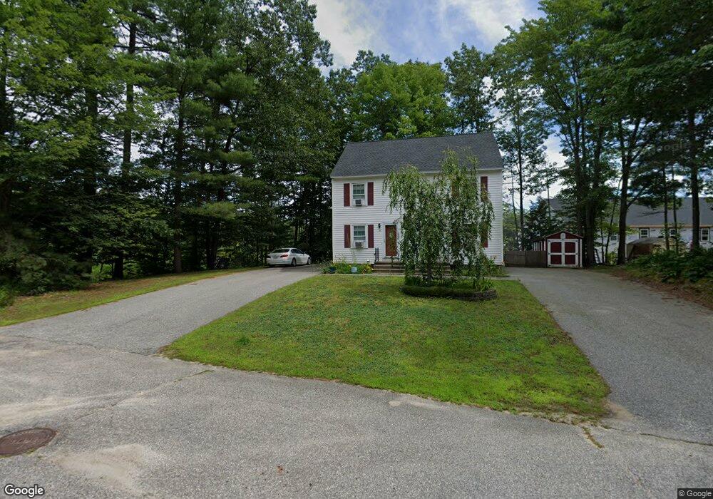
35 Springhill Dr Springvale, ME 04083
Estimated Value: $229,000 - $272,860
2
Beds
2
Baths
832
Sq Ft
$296/Sq Ft
Est. Value
About This Home
This home is located at 35 Springhill Dr, Springvale, ME 04083 and is currently estimated at $246,215, approximately $295 per square foot. 35 Springhill Dr is a home located in York County with nearby schools including St Thomas Consolidated School and Sanford Christian Academy.
Ownership History
Date
Name
Owned For
Owner Type
Purchase Details
Closed on
Jun 30, 2021
Sold by
Lenzen Robert J and Jones Kimberly R
Bought by
Morris Parker
Current Estimated Value
Home Financials for this Owner
Home Financials are based on the most recent Mortgage that was taken out on this home.
Original Mortgage
$194,370
Outstanding Balance
$174,824
Interest Rate
2.9%
Mortgage Type
Purchase Money Mortgage
Estimated Equity
$71,391
Purchase Details
Closed on
Mar 22, 2021
Sold by
Lenzen Robert B
Bought by
Everette-Lenzen Robert J and Jones Kimberly R
Create a Home Valuation Report for This Property
The Home Valuation Report is an in-depth analysis detailing your home's value as well as a comparison with similar homes in the area
Home Values in the Area
Average Home Value in this Area
Purchase History
| Date | Buyer | Sale Price | Title Company |
|---|---|---|---|
| Morris Parker | -- | None Available | |
| Everette-Lenzen Robert J | -- | None Available |
Source: Public Records
Mortgage History
| Date | Status | Borrower | Loan Amount |
|---|---|---|---|
| Open | Morris Parker | $194,370 |
Source: Public Records
Tax History
| Year | Tax Paid | Tax Assessment Tax Assessment Total Assessment is a certain percentage of the fair market value that is determined by local assessors to be the total taxable value of land and additions on the property. | Land | Improvement |
|---|---|---|---|---|
| 2025 | $2,876 | $168,200 | $17,300 | $150,900 |
| 2024 | $2,715 | $168,200 | $17,300 | $150,900 |
| 2023 | $2,522 | $166,600 | $17,300 | $149,300 |
| 2022 | $2,466 | $166,600 | $17,300 | $149,300 |
| 2021 | $1,933 | $106,300 | $17,300 | $89,000 |
| 2020 | $1,980 | $98,200 | $17,300 | $80,900 |
| 2019 | $2,033 | $98,200 | $17,300 | $80,900 |
| 2018 | $1,816 | $98,200 | $17,300 | $80,900 |
| 2017 | $1,821 | $87,800 | $17,300 | $70,500 |
| 2016 | $2,101 | $92,400 | $17,300 | $75,100 |
| 2015 | $1,816 | $92,400 | $17,300 | $75,100 |
| 2014 | $1,781 | $92,400 | $17,300 | $75,100 |
| 2013 | -- | $92,400 | $17,300 | $75,100 |
Source: Public Records
Map
Nearby Homes
- 21 Signal St Unit I-3
- 19 Signal St Unit I-2
- 17 Signal St Unit I-1
- 27 Weeman St
- 51 Pleasant St
- 5 Allenson St
- 32 Rosewood Cir
- 24 Witham St Unit 16
- 538 Main St Unit 2
- 14 Pleasant St
- 3 George St
- 11 Nathan Ct
- 6 Harris St
- 45 Payne St
- 39 Payne St
- 9 Green St
- 598 Main St
- R6-41-S3 Railroad Ave
- R6-41-S2 Railroad Ave
- R6-41-S4 Railroad Ave
- 33 Springhill Dr
- 35 Springhill Dr Unit A
- 33 Spring Hill Unit 1
- 31 Springhill Dr
- 29 Springhill Dr
- 2 Crestwood Dr
- 4 Crestwood Dr
- 1 Crestwood Dr
- 1 Crestwood Dr Unit 1
- 1 Crestwood Dr Unit 22
- 10 Crestwood Dr Unit 10A
- 3 Crestwood Dr
- 27 Springhill Dr
- 25 Springhill Dr
- 25 Springhill Dr Unit 25
- 25 Springhill Dr Unit A
- 15 Woodvale Ct
- 13 Woodvale Ct
- 13 Woodvale Ct Unit A
- 13 Woodvale Ct Unit 13A
Your Personal Tour Guide
Ask me questions while you tour the home.