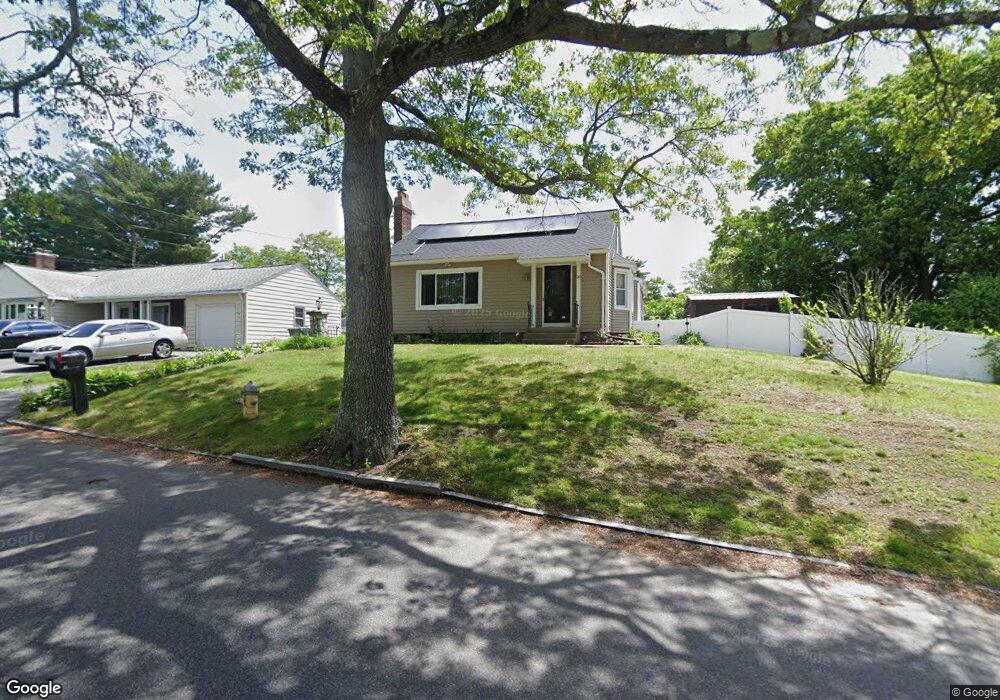
35 Wilshire Rd Springfield, MA 01118
Sixteen Acres NeighborhoodEstimated Value: $303,191 - $342,000
3
Beds
1
Bath
1,190
Sq Ft
$272/Sq Ft
Est. Value
About This Home
This home is located at 35 Wilshire Rd, Springfield, MA 01118 and is currently estimated at $323,298, approximately $271 per square foot. 35 Wilshire Rd is a home located in Hampden County with nearby schools including Arthur T Talmadge Elementary School, M Marcus Kiley Middle, and Springfield High School of Science and Technology.
Ownership History
Date
Name
Owned For
Owner Type
Purchase Details
Closed on
Jun 24, 1988
Sold by
Kogut Stanley
Bought by
Santaniello Mario
Current Estimated Value
Home Financials for this Owner
Home Financials are based on the most recent Mortgage that was taken out on this home.
Original Mortgage
$81,000
Interest Rate
10.32%
Mortgage Type
Purchase Money Mortgage
Create a Home Valuation Report for This Property
The Home Valuation Report is an in-depth analysis detailing your home's value as well as a comparison with similar homes in the area
Home Values in the Area
Average Home Value in this Area
Purchase History
| Date | Buyer | Sale Price | Title Company |
|---|---|---|---|
| Santaniello Mario | $111,000 | -- |
Source: Public Records
Mortgage History
| Date | Status | Borrower | Loan Amount |
|---|---|---|---|
| Open | Santaniello Mario | $80,000 | |
| Closed | Santaniello Mario | $15,000 | |
| Closed | Santaniello Mario | $82,500 | |
| Closed | Santaniello Mario | $81,000 |
Source: Public Records
Tax History Compared to Growth
Tax History
| Year | Tax Paid | Tax Assessment Tax Assessment Total Assessment is a certain percentage of the fair market value that is determined by local assessors to be the total taxable value of land and additions on the property. | Land | Improvement |
|---|---|---|---|---|
| 2025 | $3,827 | $244,100 | $57,800 | $186,300 |
| 2024 | $3,912 | $243,600 | $57,800 | $185,800 |
| 2023 | $3,197 | $187,500 | $55,000 | $132,500 |
| 2022 | $3,437 | $182,600 | $55,000 | $127,600 |
| 2021 | $3,069 | $162,400 | $50,000 | $112,400 |
| 2020 | $3,051 | $156,200 | $50,000 | $106,200 |
| 2019 | $3,009 | $152,900 | $50,000 | $102,900 |
| 2018 | $2,919 | $148,300 | $50,000 | $98,300 |
| 2017 | $2,866 | $145,800 | $50,000 | $95,800 |
| 2016 | $2,888 | $146,900 | $50,000 | $96,900 |
| 2015 | $2,740 | $139,300 | $50,000 | $89,300 |
Source: Public Records
Map
Nearby Homes
- 65 Wilshire Rd
- 5 Kerry Dr
- 121 W Crystal Brook Dr
- 99 W Crystal Brook Dr
- 86 Talmadge Dr
- 90 Feltham Rd
- 53 Wood End Rd
- 63 Bridle Path Rd
- 17 Pebble Mill Rd
- 54 Shady Brook Ln
- 399 Elm St
- 263 Cooley St
- 19 Ruthven St
- 19 Harbour Rd
- 196 Sawmill Rd
- 1107 Allen St
- 77 Gates Ave
- 125 Manor Ct Unit 125
- 17 Skyridge Ln
- 19 Dennis St
- 25 Wilshire Rd
- 45 Wilshire Rd
- 36 Wilshire Rd
- 26 Wilshire Rd
- 55 Wilshire Rd
- 15 Wilshire Rd
- 46 Wilshire Rd
- 16 Wilshire Rd
- 56 Wilshire Rd
- 56 Wilshire Rd Unit 56
- 5 Wilshire Rd
- 6 Wilshire Rd
- 66 Wilshire Rd
- 75 Wilshire Rd
- 76 Wilshire Rd
- 10 Allen Park Rd
- 306 Holcomb Rd
- 294 Holcomb Rd
- 322 Holcomb Rd
- 284 Holcomb Rd