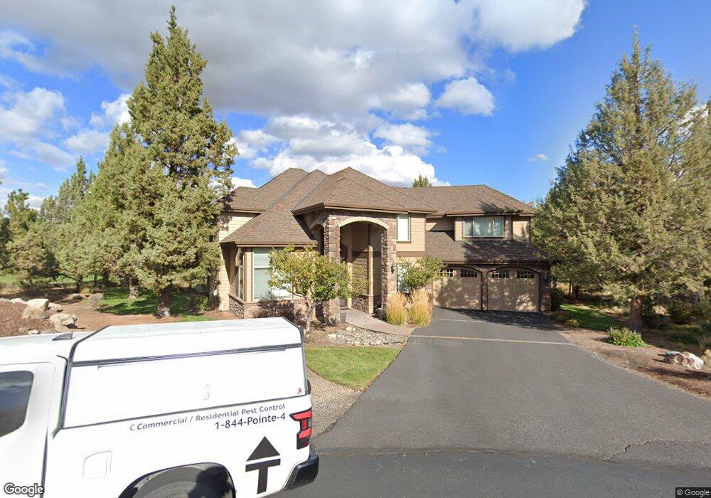
350 Avocet Ct Redmond, OR 97756
Estimated Value: $1,019,956 - $1,131,000
3
Beds
3
Baths
3,355
Sq Ft
$322/Sq Ft
Est. Value
About This Home
This home is located at 350 Avocet Ct, Redmond, OR 97756 and is currently estimated at $1,079,985, approximately $321 per square foot. 350 Avocet Ct is a home located in Deschutes County with nearby schools including Tumalo Community School, Obsidian Middle School, and Ridgeview High School.
Ownership History
Date
Name
Owned For
Owner Type
Purchase Details
Closed on
Nov 19, 2010
Sold by
Northwest Bank
Bought by
Susak Gary J and Susak Linda
Current Estimated Value
Purchase Details
Closed on
Nov 18, 2009
Sold by
2 S & T Llc
Bought by
Northwest Bank
Purchase Details
Closed on
Sep 5, 2006
Sold by
Clark Tom and Clark Tracy
Bought by
2 S & T Llc
Home Financials for this Owner
Home Financials are based on the most recent Mortgage that was taken out on this home.
Original Mortgage
$728,000
Interest Rate
6.67%
Mortgage Type
Construction
Purchase Details
Closed on
Jan 6, 2005
Sold by
Carr Jerry D and Carr Shannon M
Bought by
Clark Tom and Clark Tracy
Create a Home Valuation Report for This Property
The Home Valuation Report is an in-depth analysis detailing your home's value as well as a comparison with similar homes in the area
Home Values in the Area
Average Home Value in this Area
Purchase History
| Date | Buyer | Sale Price | Title Company |
|---|---|---|---|
| Susak Gary J | $430,000 | Amerititle | |
| Northwest Bank | -- | None Available | |
| 2 S & T Llc | $225,000 | Fidelity Natl Title Co Of Or | |
| Clark Tom | -- | Amerititle |
Source: Public Records
Mortgage History
| Date | Status | Borrower | Loan Amount |
|---|---|---|---|
| Previous Owner | 2 S & T Llc | $728,000 |
Source: Public Records
Tax History Compared to Growth
Tax History
| Year | Tax Paid | Tax Assessment Tax Assessment Total Assessment is a certain percentage of the fair market value that is determined by local assessors to be the total taxable value of land and additions on the property. | Land | Improvement |
|---|---|---|---|---|
| 2025 | $7,433 | $439,510 | -- | -- |
| 2024 | $7,105 | $426,710 | -- | -- |
| 2023 | $6,773 | $414,290 | $0 | $0 |
| 2022 | $6,030 | $390,520 | $0 | $0 |
| 2021 | $6,029 | $379,150 | $0 | $0 |
| 2020 | $5,737 | $379,150 | $0 | $0 |
| 2019 | $5,469 | $368,110 | $0 | $0 |
| 2018 | $5,338 | $357,390 | $0 | $0 |
| 2017 | $5,219 | $346,990 | $0 | $0 |
| 2016 | $5,157 | $336,890 | $0 | $0 |
| 2015 | $4,997 | $327,080 | $0 | $0 |
| 2014 | $4,866 | $317,560 | $0 | $0 |
Source: Public Records
Map
Nearby Homes
- 454 Tanager Dr
- 387 Goshawk Ct
- 665 Nutcracker Dr
- 722 Golden Pheasant Dr
- 825 Victoria Falls Dr
- 412 NW 83rd St
- 830 Willet Ln
- 909 Willet Ln
- 855 Golden Pheasant Dr
- 964 Golden Pheasant Dr
- 8540 Golden Pheasant Ct
- 1044 Golden Pheasant Dr
- 1036 Niagara Falls Dr
- 1084 Golden Pheasant Dr
- 1140 Golden Pheasant Dr
- 987 Golden Pheasant Dr
- 920 Cinnamon Teal Dr
- 1442 Eagle Springs Ct
- 6822 Thunderbird Ct
- 1471 Red Wing Loop